
|
10.1.1 - still no X-trak (single line) |
Post Reply 
|
| Author | |||||||||||||||||||||||||||
oskrypuch 
Senior Member 
Joined: 09 Nov 2012 Location: CYFD Status: Offline Points: 3062 |
 Post Options Post Options
") Thanks(0) Thanks(0)
 Quote Reply Quote Reply
 Topic: 10.1.1 - still no X-trak (single line) Topic: 10.1.1 - still no X-trak (single line)Posted: 21 Dec 2015 at 12:07pm |
||||||||||||||||||||||||||
|
I enjoyed having the crosstrack indication on the top line of the 540 right above the map, you could do that in 10.0.3.
It has still not made it back, yet, in 10.1.1. You need to have this datablock adjust to a single line, for it to fit there. Can you put this on the list for 10.1.2? * Orest |
|||||||||||||||||||||||||||
 |
|||||||||||||||||||||||||||
|
AviJake
Admin Group 
Joined: 26 Mar 2009 Location: Lincoln MA Status: Offline Points: 2815 |
Post Options
Thanks(0)
Quote Reply
Posted: 21 Dec 2015 at 1:03pm |
||||||||||||||||||||||||||
|
It's already done and included in Rel 10.2 - just waiting for the cert train to catch up.
|
|||||||||||||||||||||||||||
|
Steve Jacobson
sjacobson@avidyne.com |
|||||||||||||||||||||||||||
|
|||||||||||||||||||||||||||
|
oskrypuch
Senior Member
Joined: 09 Nov 2012 Location: CYFD Status: Offline Points: 3062 |
Post Options
Thanks(0)
Quote Reply
Posted: 21 Dec 2015 at 2:25pm |
||||||||||||||||||||||||||
|
Oh, very good.
Perhaps you can't say, but is 10.2 feature/fix frozen, or perhaps even in final software form and in the FAA's hands? In any case, look forward to a tickler of what is expected in 10.2, at some time in the future. * Orest |
|||||||||||||||||||||||||||
|
|||||||||||||||||||||||||||
|
AviJake
Admin Group
Joined: 26 Mar 2009 Location: Lincoln MA Status: Offline Points: 2815 |
Post Options
Thanks(0)
Quote Reply
Posted: 21 Dec 2015 at 2:26pm |
||||||||||||||||||||||||||
|
Copy that but it's so juicy, I'm not going to publish that list until the finish line can be reached by a ping pong ball.
|
|||||||||||||||||||||||||||
|
Steve Jacobson
sjacobson@avidyne.com |
|||||||||||||||||||||||||||
|
|||||||||||||||||||||||||||
|
oskrypuch
Senior Member
Joined: 09 Nov 2012 Location: CYFD Status: Offline Points: 3062 |
Post Options
Thanks(0)
Quote Reply
Posted: 21 Dec 2015 at 3:49pm |
||||||||||||||||||||||||||
Well, you've set the bar high! Looking forward to the best GPS/COM getting even better. * Orest |
|||||||||||||||||||||||||||
|
|||||||||||||||||||||||||||
|
ddgates
Senior Member

Joined: 12 Aug 2011 Location: Deer Valley Status: Offline Points: 1100 |
Post Options
Thanks(0)
Quote Reply
Posted: 21 Dec 2015 at 5:16pm |
||||||||||||||||||||||||||
|
Hooray!
Even though I have the same gear, I had the pleasure of flying with Tom yesterday in his Comanche (Piper, yeah I know). Impressive. I think that Tom has done the familiarization tour, he may or may not be a superuser but he was able to use the boxes to do some cool stuff. I look forward to getting facile with my boxes, and exploring the features Avidyne will be pushing out to its users. Thanks.
|
|||||||||||||||||||||||||||
|
David Gates
|
|||||||||||||||||||||||||||
|
|||||||||||||||||||||||||||
|
DavidBunin
Senior Member

Joined: 20 May 2015 Location: Rockwall, TX Status: Offline Points: 742 |
Post Options
Thanks(0)
Quote Reply
Posted: 21 Dec 2015 at 6:00pm |
||||||||||||||||||||||||||
|
But the 10.2.0.0 software is frozen, right? Anything new being discussed or debated here (whether its features or fixes) should be thought of in terms of 10.2.1.0 (or even 10.3 depending on severity)? At this point in the process, I would expect that only the FAA themselves are in a position to request changes in 10.2.0.0 (and have any reasonable expectation that such a request might be granted). David Bunin |
|||||||||||||||||||||||||||
|
|||||||||||||||||||||||||||
|
AviJake
Admin Group
Joined: 26 Mar 2009 Location: Lincoln MA Status: Offline Points: 2815 |
Post Options
Thanks(0)
Quote Reply
Posted: 21 Dec 2015 at 6:50pm |
||||||||||||||||||||||||||
|
Oh yes, it's definitely frozen. But it can temporarily thaw out during the next few weeks as we get into official test for credit. There may be small items on the periphery that move in/out for a few more weeks until that test-for-credit testing is done and the FAA has finished their evaluations.
10.2.1 stuff would be bug fixes. 10.3 is already defined and ready to start work on as soon as we get through a few more 10.2 milestones. |
|||||||||||||||||||||||||||
|
Steve Jacobson
sjacobson@avidyne.com |
|||||||||||||||||||||||||||
|
|||||||||||||||||||||||||||
|
oskrypuch
Senior Member
Joined: 09 Nov 2012 Location: CYFD Status: Offline Points: 3062 |
Post Options
Thanks(0)
Quote Reply
Posted: 21 Dec 2015 at 8:38pm |
||||||||||||||||||||||||||
The elfs are busy. Is the Boeing Banana somewhere in there ??? * Orest Edited by oskrypuch - 21 Dec 2015 at 8:41pm |
|||||||||||||||||||||||||||
|
|||||||||||||||||||||||||||
|
tony
Senior Member

Joined: 06 Dec 2011 Location: Atlanta Status: Offline Points: 466 |
Post Options
Thanks(0)
Quote Reply
Posted: 22 Dec 2015 at 6:35am |
||||||||||||||||||||||||||
|
Its not the Boeing Banana, its the Orest Banana. It will always be defined that way in my head.
|
|||||||||||||||||||||||||||
|
|||||||||||||||||||||||||||
|
bellanca1730a
Groupie 

Joined: 04 Jul 2013 Location: Tampa Status: Offline Points: 63 |
Post Options
Thanks(0)
Quote Reply
Posted: 22 Dec 2015 at 8:21am |
||||||||||||||||||||||||||
|
+1 (again) on the *Orest* banana.
|
|||||||||||||||||||||||||||
|
Sean Andrews
Bellanca Super Viking |
|||||||||||||||||||||||||||
|
|||||||||||||||||||||||||||
|
DavidBunin
Senior Member
Joined: 20 May 2015 Location: Rockwall, TX Status: Offline Points: 742 |
Post Options
Thanks(0)
Quote Reply
Posted: 22 Dec 2015 at 9:02am |
||||||||||||||||||||||||||
|
Speaking from experience, this is a tricky time for a software engineer. Making sure you roll all of the late-incorporation changes that are made to the current project (10.2) into the pending project (10.3). Otherwise, when 10.3 comes out there are a handful of "solved" problems (from 10.1) that were fixed in 10.2 but come back to life in 10.3. Or, put another way... I just want to tell you both good luck. We're all counting on you. David Bunin |
|||||||||||||||||||||||||||
|
|||||||||||||||||||||||||||
|
ddgates
Senior Member
Joined: 12 Aug 2011 Location: Deer Valley Status: Offline Points: 1100 |
Post Options
Thanks(0)
Quote Reply
Posted: 22 Dec 2015 at 10:37am |
||||||||||||||||||||||||||
+1, and thanks
|
|||||||||||||||||||||||||||
|
David Gates
|
|||||||||||||||||||||||||||
|
|||||||||||||||||||||||||||
|
ptlevine
Groupie
Joined: 06 Aug 2014 Location: United States Status: Offline Points: 53 |
Post Options
Thanks(0)
Quote Reply
Posted: 23 Dec 2015 at 10:31am |
||||||||||||||||||||||||||
|
Has anyone requested the TODs for each crossing restriction to be available as discrete waypoint in the flight plan?
|
|||||||||||||||||||||||||||
|
|||||||||||||||||||||||||||
|
oskrypuch
Senior Member
Joined: 09 Nov 2012 Location: CYFD Status: Offline Points: 3062 |
Post Options
Thanks(0)
Quote Reply
Posted: 23 Dec 2015 at 1:43pm |
||||||||||||||||||||||||||
I assume you mean the flightplan listing on the FMS page, with the time and fuel calcs to the TOD all included? I made that request, some time ago. I don't know if it made the future consideration database, there was never a reply, but Jake does read most every post. IAC, worth tickling that again. It would be a powerful feature, and it is a normal feature in any FMS. * Orest Edited by oskrypuch - 23 Dec 2015 at 1:55pm |
|||||||||||||||||||||||||||
|
|||||||||||||||||||||||||||
|
AviJake
Admin Group
Joined: 26 Mar 2009 Location: Lincoln MA Status: Offline Points: 2815 |
Post Options
Thanks(0)
Quote Reply
Posted: 24 Dec 2015 at 8:17am |
||||||||||||||||||||||||||
|
Yes, all of those TOD improvements are in the future feature candidate database. They have a pretty high internal score too.
|
|||||||||||||||||||||||||||
|
Steve Jacobson
sjacobson@avidyne.com |
|||||||||||||||||||||||||||
|
|||||||||||||||||||||||||||
|
oskrypuch
Senior Member
Joined: 09 Nov 2012 Location: CYFD Status: Offline Points: 3062 |
Post Options
Thanks(0)
Quote Reply
Posted: 24 Dec 2015 at 10:20am |
||||||||||||||||||||||||||
|
Excellent.
* Orest |
|||||||||||||||||||||||||||
|
|||||||||||||||||||||||||||
|
khuffine
Groupie
Joined: 12 Dec 2015 Location: GSO Status: Offline Points: 68 |
Post Options
Thanks(0)
Quote Reply
Posted: 24 Dec 2015 at 6:30pm |
||||||||||||||||||||||||||
|
The Orest arc is also great for a single engine out. Keep it north of the airport and make the field, or know you won't make it. Also a 'FIX" page would be great to have to show ABEAM points or Alternates at a glance. The rubber band is great but it does take you off track..abeam point for a midpoint in the flight plan would be something i would use.
|
|||||||||||||||||||||||||||
|
Khuffine
|
|||||||||||||||||||||||||||
|
|||||||||||||||||||||||||||
|
oskrypuch
Senior Member
Joined: 09 Nov 2012 Location: CYFD Status: Offline Points: 3062 |
Post Options
Thanks(0)
Quote Reply
Posted: 24 Dec 2015 at 9:45pm |
||||||||||||||||||||||||||
|
I've been talking about FIX pages here a while as well. To show some of the new folks what that is ...
"Fix" circles have been drawn in at 10nm & 20nm, centered on KSEA (737 MFD) 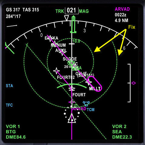 These aren't range rings in the same sense, as the IFD shows centering on OWN SHIP. The FIX marks that I'm mentioning, and that K comments on, are relative to any waypoint that you designate! There is a so-called FIX page on the FMS (CDU) to do this. In the pic there are two FIX ranges set, marked with light dashed green circles. Both are centered on KSEA, one to show a 10nm range, and the other 20nm. You can also specify a radial to be drawn in. These markings act like other elements in the display, such as airports, VORs, and will move when the view is scrolled, and will scale as the display scale is changed. In essence you have sketched in additional reference markings on the map. They become part of the map. It is an incredibly powerful feature, as it gives instant orientation to destinations, departures (say for complicated SIDs), intermediate navigation help, marking of range to ETOPS airports, or areas to avoid, and so on. And what is shown on the screen, is up to the pilot. There were originally two FIX pages, there are now six in the latest software on the NGXs. Each FIX page handles one FIX element(s). That can be an airport, nav beacon or any named waypoint. Once a name is filled in, you then specify up to three distance circles to be drawn, and each circle designation can also include a radial to be drawn with it. Setting a 10nm & 20nm circle to your destination airport, with a radial drawn in parallel to the planned runway, is an obvious choice. A FIX page-like feature for the IFD is just a suggested feature, but Steve has put it on the future feature candidate list, as far as I know. * Orest Edited by oskrypuch - 24 Dec 2015 at 9:48pm |
|||||||||||||||||||||||||||
|
|||||||||||||||||||||||||||
|
oskrypuch
Senior Member
Joined: 09 Nov 2012 Location: CYFD Status: Offline Points: 3062 |
Post Options
Thanks(0)
Quote Reply
Posted: 24 Dec 2015 at 9:52pm |
||||||||||||||||||||||||||
|
Also borrowing another Collins/Honeywell feature, I've put in a request for special waypoints, which I believe is also in the database ...
Crossing radials: JFK190/CYN100 rad/dist: JFK190/25 5nm before a waypoint (eg. HOPCE) already in the flightplan: HOPCE/-5 lat/long, N 47.0, W 080.0 N470W0800 * Orest Edited by oskrypuch - 24 Dec 2015 at 9:55pm |
|||||||||||||||||||||||||||
|
|||||||||||||||||||||||||||
|
khuffine
Groupie
Joined: 12 Dec 2015 Location: GSO Status: Offline Points: 68 |
Post Options
Thanks(0)
Quote Reply
Posted: 29 Dec 2015 at 5:31pm |
||||||||||||||||||||||||||
|
That would be great....Makes you want to be a pilot!
|
|||||||||||||||||||||||||||
|
Khuffine
|
|||||||||||||||||||||||||||
|
|||||||||||||||||||||||||||
|
oskrypuch
Senior Member
Joined: 09 Nov 2012 Location: CYFD Status: Offline Points: 3062 |
Post Options
Thanks(0)
Quote Reply
Posted: 29 Dec 2015 at 5:52pm |
||||||||||||||||||||||||||
Hee, Hee.  |
|||||||||||||||||||||||||||
|
|||||||||||||||||||||||||||
|
AzAv8r
Senior Member
Joined: 06 Dec 2011 Location: Arizona Status: Offline Points: 154 |
Post Options
Thanks(0)
Quote Reply
Posted: 29 Dec 2015 at 9:07pm |
||||||||||||||||||||||||||
|
N470W0800 hurts my head: presumably you are suggesting an arbitrary (or at least variable to some larger) number of digits, as long as the entered MSD is consistent with the maximum MSD for lat or long. Is this interpretation correct?
With N470W0800 that's only +/- 3NM precision (ok, +/- 2 for longitude given the latitude). I'd think at least one more digit of precision would be necessary to be reasonably useful, and really expect at least two more digits, which would put the precision at about +/- 180' - not nearly as good as WAAS GPS is capable of, but close enough that the outcome would (usually) match your expectation. |
|||||||||||||||||||||||||||
|
|||||||||||||||||||||||||||
|
oskrypuch
Senior Member
Joined: 09 Nov 2012 Location: CYFD Status: Offline Points: 3062 |
Post Options
Thanks(0)
Quote Reply
Posted: 29 Dec 2015 at 9:19pm |
||||||||||||||||||||||||||
|
The lat/long input is taken as precisely that lat/long. No decimals are used after the first. It is not uncommon for flightplans to receive such RNav waypoints, that consist of major lat/long crossings.
So N470W0800 is lat/long, N 47.000000, W 080.000000 In the Honeywell FMC, it always expects those nine digits (seven digits in some builds), with that format. There is no reason that Avidyne couldn't change that. Honeywell will also accept a five digit format, which is a little mysterious until you understand. These are typically used for oceanic waypoints. They will really make your head hurt. * Orest ~~~~~~~~~~~~~~~~~~~~~~~~~~~~~~~~~~~~~~ The ARINC 424 Format is a five-character format consisting of four numbers and one alpha character, in either NNANN or NNNNA format. The first two numbers represent the latitude in whole degrees and the last two numbers are the longitude in whole degrees. If the longitude is greater than 99° the appropriate alpha character is placed between the numbers, otherwise the alpha character is positioned right of the four numbers. The alpha characters "N", "E", "W", and "S" indicate positions within the northern or southern hemisphere for latitude, and the western or eastern hemisphere for longitude: "N" = north latitude / west longitude "E" = north latitude / east longitude "W"= south latitude / west longitude "S" = south latitude / east longitude The FMS Lat/Long Format is a self-explanatory seven-character format (NNANNNA) showing whole LAT/LONG degrees (see example below).
OWPT examples of both formats:
Edited by oskrypuch - 29 Dec 2015 at 9:23pm |
|||||||||||||||||||||||||||
|
|||||||||||||||||||||||||||
|
Post Reply
|
|
 Tweet
Tweet
|
| Forum Jump | Forum Permissions You cannot post new topics in this forum You cannot reply to topics in this forum You cannot delete your posts in this forum You cannot edit your posts in this forum You cannot create polls in this forum You cannot vote in polls in this forum |


")


 Topic Options
 AviJake wrote: