
|
Feature Request: better highlight of next waypoint |
Post Reply 
|
| Author | ||
oskrypuch 
Senior Member 
Joined: 09 Nov 2012 Location: CYFD Status: Offline Points: 3062 |
 Post Options Post Options
") Thanks(0) Thanks(0)
 Quote Reply Quote Reply
 Topic: Feature Request: better highlight of next waypoint Topic: Feature Request: better highlight of next waypointPosted: 05 Mar 2015 at 5:36pm |
|
|
I am often left straining to see the precise location of the next waypoint on the screen, especially on approach when the screen starts to become busier. Sure there are datablocks, but I like to be able to visually gauge my position.
As such, I'd like to request two simple things that would go a long way to this, or if you have any other bright ideas! 1) increase the NEXT waypoint indicator size by say 50%, and give it a slightly stronger border 2) reverse the order of the "barber pole" magenta/white striping, so that the first stripe past the NEXT waypoint is WHITE, instead of MAGENTA, that helps give further contrast. I have done a little editing in the image below to show what I mean. And although I don't depict it, changing the barber pole to something like 75% white/25% magenta would make it even stronger and less visually confusing. And for that matter, you might wish to slightly increase the size of the other waypoint marks too. 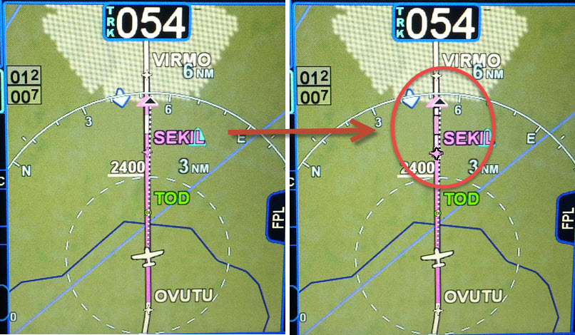 * Orest Edited by oskrypuch - 05 Mar 2015 at 5:41pm |
||
 |
||
|
twalterhome3
Groupie 
Joined: 06 Sep 2012 Location: CA Status: Offline Points: 43 |
Post Options
Thanks(0)
Quote Reply
Posted: 05 Mar 2015 at 6:59pm |
|
|
yes that's a great idea
+1
|
||
|
Tim
|
||
|
||
|
AviJake
Admin Group 
Joined: 26 Mar 2009 Location: Lincoln MA Status: Offline Points: 2815 |
Post Options
Thanks(0)
Quote Reply
Posted: 05 Mar 2015 at 7:39pm |
|
|
Added. Thanks.
|
||
|
Steve Jacobson
sjacobson@avidyne.com |
||
|
||
|
oskrypuch
Senior Member
Joined: 09 Nov 2012 Location: CYFD Status: Offline Points: 3062 |
Post Options
Thanks(0)
Quote Reply
Posted: 05 Mar 2015 at 8:10pm |
|
|
Thank you.
* Orest |
||
|
||
|
oskrypuch
Senior Member
Joined: 09 Nov 2012 Location: CYFD Status: Offline Points: 3062 |
Post Options
Thanks(0)
Quote Reply
Posted: 11 Jun 2016 at 2:58pm |
|
|
Did this one make 10.2, per chance?
* Orest |
||
|
||
|
cavu
Senior Member
Joined: 17 Apr 2015 Location: KRME Status: Offline Points: 152 |
Post Options
Thanks(0)
Quote Reply
Posted: 17 Jun 2016 at 10:21am |
|
|
The 540 series IFD has all the data to compute the TIME to the MAP (Missed approach chart). Instead of trying to interpolate between the 90 and 120kts times printed on the approach chart, setup in a count-down timer etc, it would be nice to be able to show in one of the data blocks the actual time (based on actual ground speed) and the time left. It could actually self toggle on when reaching the FAF if a VOR/ILS approach is loaded. MAP 2:40 REM 1:49 |
||
|
||
|
oskrypuch
Senior Member
Joined: 09 Nov 2012 Location: CYFD Status: Offline Points: 3062 |
Post Options
Thanks(0)
Quote Reply
Posted: 17 Jun 2016 at 10:43am |
|
I like that too! * Orest |
||
|
||
|
Catani
Senior Member
Joined: 21 Jan 2016 Status: Offline Points: 362 |
Post Options
Thanks(0)
Quote Reply
Posted: 17 Jun 2016 at 11:56am |
|
I'm a little puzzled by this request. In the old days, we often had to time non-precision approaches in order to know when to go missed. But now, with GPS to tell us exactly where we are, the need for the GPS to tell us the time elapsed is a much less precise way for the GPS to tell us we are getting close to, or upon, or past, the missed approach point. In fact, no matter what the timing says based upon estimates of groundspeed over time, when the GPS says you're at the missed approach point you go missed. And if you're wondering how close you are to that point, look at the distance the GPS tells you is left to go. Now many pilots will continue to monitor the time after the FAF just like the old days out of habit, if for no other reason than to guard against the possibility the GPS might fail half way down final. If you knew your time and were using a VOR or LOC or ADF for your final approach guidance, you could continue the approach even after such failure. If you weren't monitoring your time and were relying upon the now-failed GPS to identify the missed approach point, you'd have to go missed. But in that scenario, having the GPS keep track of your time would do you no good, as now it's busted. Better to do it on your watch or clock, which presumably would allow you to complete the approach after GPS failure. Again, however, if the GPS remains in good working order, who needs to know the time? In other words, keeping track of time is for your watch; keeping track of the distance to go is for your GPS. At least, this is how I see it, for what it's worth.
|
||
|
||
|
oskrypuch
Senior Member
Joined: 09 Nov 2012 Location: CYFD Status: Offline Points: 3062 |
Post Options
Thanks(0)
Quote Reply
Posted: 17 Jun 2016 at 8:53pm |
|
|
Having the time displayed makes it a calculation you don't need to do. Time to MAP is more intuitive than distance.
* Orest |
||
|
||
|
teeth6
Senior Member
Joined: 10 Mar 2014 Status: Offline Points: 741 |
Post Options
Thanks(0)
Quote Reply
Posted: 20 Jun 2016 at 7:30pm |
|
|
A small change to the "Freq" button is something I'd like to see in a future request. Maybe this has been mentioned already but just in case....... Steve said that he changes frequencies on a trip by hitting the Freq button, going to "Enroute" and then selecting the appropriate frequency. I tried this on a recent trip and noticed that each time you hit the "Freq" button, it takes you only to the first screen (I believe it is Airports). You then have to hit Freq again or touch "Enroute" to toggle over. It would make sense to bring you back to the Enroute screen or whichever screen you were on when you left it to go back to Maps. I imagine Steve spends most of his time on the Enroute Freq tab due to the multiple freq changes on a trip and if an extra button push could be eliminated by going directly back to the page you left, that would be great
Edited by teeth6 - 10 Jul 2016 at 7:46pm |
||
|
||
|
paulr
Senior Member
Joined: 24 Jan 2014 Status: Offline Points: 564 |
Post Options
Thanks(0)
Quote Reply
Posted: 21 Jun 2016 at 12:47pm |
|
|
Yes please.
|
||
|
||
|
cavu
Senior Member
Joined: 17 Apr 2015 Location: KRME Status: Offline Points: 152 |
Post Options
Thanks(0)
Quote Reply
Posted: 01 Jul 2016 at 3:51pm |
|
If the Waypoint data block had the ETE in minutes and seconds, this would give you the time to the MAP (assuming you aren't past it and the next waypoint is the missed holding fix). Perhaps the destination ETE in MM:SS would work. Right now all ETEs are HH:MM.
|
||
|
||
|
AviJake
Admin Group
Joined: 26 Mar 2009 Location: Lincoln MA Status: Offline Points: 2815 |
Post Options
Thanks(0)
Quote Reply
Posted: 10 Jul 2016 at 9:48am |
|
|
I agree that the datablocks would be useful for MM:SS when under 10 min and I'll add that to the future feature candidate database now.
One noteworthy item is that the FMS tab legs show HH:MM until the time-to-go is under 10 min, at which time it changes to MM:SS. So, you could use that FMS tab to get the to-the-second countdown if you wanted. So, the database entry is to show HH:MM until under 10 minutes at which time it would go to MM:SS for the datablocks. |
||
|
Steve Jacobson
sjacobson@avidyne.com |
||
|
||
|
oskrypuch
Senior Member
Joined: 09 Nov 2012 Location: CYFD Status: Offline Points: 3062 |
Post Options
Thanks(0)
Quote Reply
Posted: 10 Jul 2016 at 1:22pm |
|
|
Well, Jake is BACK.
What about the first post in this thread, is the above quoted feature in the candiate database? * Orest Edited by oskrypuch - 10 Jul 2016 at 1:23pm |
||
|
||
|
AviJake
Admin Group
Joined: 26 Mar 2009 Location: Lincoln MA Status: Offline Points: 2815 |
Post Options
Thanks(0)
Quote Reply
Posted: 10 Jul 2016 at 1:27pm |
|
|
Yes, I'm back as of last night but I've got to say that after spending 2.5 weeks playing around in Croatia, I haven't stopped longing to be back there instead of at work.
As for the real point of the post, I just entered those two points in the future feature database (I didn't see them in there so the prod was warranted). |
||
|
Steve Jacobson
sjacobson@avidyne.com |
||
|
||
|
oskrypuch
Senior Member
Joined: 09 Nov 2012 Location: CYFD Status: Offline Points: 3062 |
Post Options
Thanks(0)
Quote Reply
Posted: 10 Jul 2016 at 1:43pm |
|
|
Understood, on both counts!
* Orest |
||
|
||
|
khuffine
Groupie

Joined: 12 Dec 2015 Location: GSO Status: Offline Points: 68 |
Post Options
Thanks(0)
Quote Reply
Posted: 10 Jul 2016 at 7:03pm |
|
|
I think by putting all three waypoints in order is the way to have the unit set up for giving position reports, especially if flying international. You could just read," estimate waypoint at, then next...then last compulsory..usually apps have several lead in apps points on the FMC. I have mine set up like that...
|
||
|
Khuffine
|
||
|
||
|
oskrypuch
Senior Member
Joined: 09 Nov 2012 Location: CYFD Status: Offline Points: 3062 |
Post Options
Thanks(0)
Quote Reply
Posted: 03 Feb 2022 at 9:25pm |
|
|
ADDED! (a bit ago)
|
||
|
||
|
Post Reply
|
|
 Tweet
Tweet
|
| Forum Jump | Forum Permissions You cannot post new topics in this forum You cannot reply to topics in this forum You cannot delete your posts in this forum You cannot edit your posts in this forum You cannot create polls in this forum You cannot vote in polls in this forum |


 Topic Options
 cavu wrote: