
|
Altitude constraints |
Post Reply 
|
| Author | |
jeffcb 
Newbie 
Joined: 05 Apr 2018 Status: Offline Points: 31 |
 Post Options Post Options
") Thanks(0) Thanks(0)
 Quote Reply Quote Reply
 Topic: Altitude constraints Topic: Altitude constraintsPosted: 10 Jul 2018 at 6:40am |
|
I am having trouble with altitude constraints in my IFD 540.
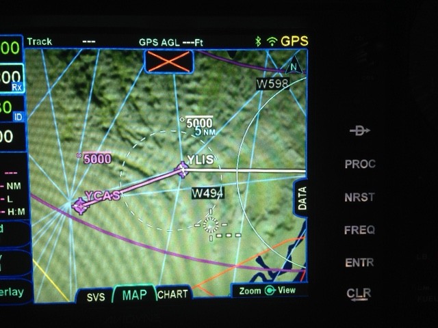
If an altitude constraint is entered for the first leg of an active flight plan, it shows on the map on the wrong side of the first waypoint. Either that or sometimes directly north of the first way point. Secondly, if the active route is closed and then reopened, all the entered altitude constraints disappear. Is this normal? Regards Jeff
|
|
|
Jeff
|
|
 |
|
|
AviSteve
Admin Group 

Joined: 12 Feb 2018 Location: Melbourne, FL Status: Offline Points: 2326 |
Post Options
Thanks(0)
Quote Reply
Posted: 10 Jul 2018 at 9:25am |
The altitude constraint generally appears under the waypoint label on the map. However, my guess is that you have an offset applied to the constraint. In that case, the label will move to that point along the flight plan. Look at the altitude constraint definition on the leg (FPL page) and make sure the "Cross" field has zero in it. If the waypoint is an airport, the system will default to 5.0nm before the point. When you say closed and reopened, I'm assuming you mean that you have defined a stored route and you activate it to make it your flight plan. User entered constraints are retained in stored routes, but only for those legs that are not a part of a procedure - airway, departure, arrival, approach.
|
|
|
Steve Lindsley
Avidyne Engineering |
|
|
|
|
jeffcb
Newbie
Joined: 05 Apr 2018 Status: Offline Points: 31 |
Post Options
Thanks(0)
Quote Reply
Posted: 10 Jul 2018 at 11:09pm |
|
Hi Steve,
Thanks for the reply. I am entering an offset. eg cross 5 nm before xxx at or below 5000 feet. What I am seeing is the point that is created on the magenta track line to show this constraint on the map, is being shown after the relevant waypoint, not before it. And sometimes it is not even on the track. As mentioned it is only on the first leg of the active flight plan that it happens. This does not happen when a constraint is applied to subsequent legs of the flight plan. It may not be relevant, but these flight plans were created in Ozrunways and sent to the Avidyne via the Avidyne WiFi network. I applied the altitude constraints to the flight plans in the Avidyne after it had received these flight plans. Regards Jeff
|
|
|
Jeff
|
|
|
|
|
jeffcb
Newbie
Joined: 05 Apr 2018 Status: Offline Points: 31 |
Post Options
Thanks(0)
Quote Reply
Posted: 11 Jul 2018 at 2:02am |
|
Hi Steve,
Have done more testing. This issue has nothing to do with Ozrunways. When an altitude constraint is entered relating to the first waypoint after the origin waypoint, on the map it appears to place the constraint indicator North of the first waypoint by the same number of NM entered in the "cross" field. My original confusion was caused because the leg of the flight plan I was using was running due North, so it appeared to enter the indicator after the waypoint. Subsequent legs are OK. Jeff |
|
|
Jeff
|
|
|
|
|
AviSteve
Admin Group
Joined: 12 Feb 2018 Location: Melbourne, FL Status: Offline Points: 2326 |
Post Options
Thanks(0)
Quote Reply
Posted: 11 Jul 2018 at 9:15am |
So are we good? I can't tell. If not, posting a picture would be helpful.
|
|
|
Steve Lindsley
Avidyne Engineering |
|
|
|
|
jeffcb
Newbie
Joined: 05 Apr 2018 Status: Offline Points: 31 |
Post Options
Thanks(0)
Quote Reply
Posted: 12 Jul 2018 at 7:11am |
|
Hi Steve,
Not sure where my last post went. More testing seems indicate that this issue occurs on the active leg of the flight plan. The altitude constraint indicator shows on the map page North of the relevant waypoint by about the same distance that is entered in the "cross" field on the FPL page. If other users are not seeing this then I must be doing something very wrong. Have photos but can't see how to post them on this forum. Regards Jeff
|
|
|
Jeff
|
|
|
|
|
MysticCobra
Senior Member 

Joined: 29 Jan 2013 Status: Offline Points: 679 |
Post Options
Thanks(0)
Quote Reply
Posted: 12 Jul 2018 at 8:23am |
|
If you can't post a photo, can you post a step-by-step procedure for duplicating the problem?
|
|
|
|
|
AviSteve
Admin Group
Joined: 12 Feb 2018 Location: Melbourne, FL Status: Offline Points: 2326 |
Post Options
Thanks(0)
Quote Reply
Posted: 12 Jul 2018 at 10:02am |
I posted instructions on how to include an image in a post. See http://www.avidynelive.com/topic1560_post19292.html#19292 Edited by AviSteve - 12 Jul 2018 at 10:03am |
|
|
Steve Lindsley
Avidyne Engineering |
|
|
|
|
AviSteve
Admin Group
Joined: 12 Feb 2018 Location: Melbourne, FL Status: Offline Points: 2326 |
Post Options
Thanks(0)
Quote Reply
Posted: 13 Jul 2018 at 9:07am |
|
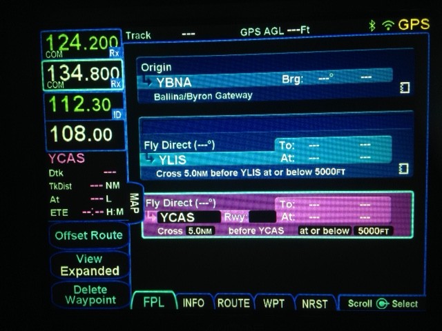
Posting relevant pictures for jeffcb...
  |
|
|
Steve Lindsley
Avidyne Engineering |
|
|
|
|
AviSteve
Admin Group
Joined: 12 Feb 2018 Location: Melbourne, FL Status: Offline Points: 2326 |
Post Options
Thanks(0)
Quote Reply
Posted: 13 Jul 2018 at 9:09am |
|
Definitely something I've not seen before. Not that it's an excuse, but my guess is that it has to do with the fact that there is no GPS position. I'll have a look in the software.
|
|
|
Steve Lindsley
Avidyne Engineering |
|
|
|
|
Post Reply
|
|
 Tweet
Tweet
|
| Forum Jump | Forum Permissions You cannot post new topics in this forum You cannot reply to topics in this forum You cannot delete your posts in this forum You cannot edit your posts in this forum You cannot create polls in this forum You cannot vote in polls in this forum |


 Topic Options
 jeffcb wrote: