
|
Suggestions for 10.3 |
Post Reply 
|
Page <1 56789> |
| Author | |||
n7ifr 
Senior Member 

Joined: 05 Aug 2013 Location: Scottsdale, Az Status: Offline Points: 470 |
 Post Options Post Options
") Thanks(0) Thanks(0)
 Quote Reply Quote Reply
 Posted: 03 Oct 2018 at 9:04pm Posted: 03 Oct 2018 at 9:04pm |
||
|
Develop IFD X40 display capability of TASA 1090-ADSB IN using UAT Format
- just like with MLB UAT 978-In - with Speed Vectors + all other good info. Tom W.
|
|||
 |
|||
|
jhbehrens
Senior Member
Joined: 15 Dec 2012 Location: Netherlands Status: Offline Points: 122 |
Post Options
Thanks(0)
Quote Reply
Posted: 24 Sep 2018 at 11:35am |
||
You are completely right of course, just never considered using it for that purpose.
This feature really requires a glideslope indication on the Aspen/HSI to be useful - effectively GTNs now allow you to fly quasi LNAV/VNAV approaches to any runway
Edited by jhbehrens - 24 Sep 2018 at 11:38am |
|||
|
|||
|
AZ Flyer
Senior Member
Joined: 12 Feb 2018 Location: Tucson, AZ Status: Offline Points: 164 |
Post Options
Thanks(0)
Quote Reply
Posted: 22 Sep 2018 at 8:22pm |
||
|
Thanks. It would be nice to be able to use the runway fix as the MDA waypoint and have the altitude and miles before options available as with other nonapproach waypoints. I did get the banana by putting the MDA in the destination airport, so at least that is there.
Edited by AZ Flyer - 22 Sep 2018 at 8:25pm |
|||
|
|||
|
oskrypuch
Senior Member
Joined: 09 Nov 2012 Location: CYFD Status: Offline Points: 3058 |
Post Options
Thanks(0)
Quote Reply
Posted: 22 Sep 2018 at 6:44pm |
||
|
Well, the MDA does not appear as a discrete waypoint, so you can't attach a vertical constraint to it.
You would have to create the vertical constraint from the airport fix, and allow for the slightly different distance. * Orest |
|||
|
|||
|
AZ Flyer
Senior Member
Joined: 12 Feb 2018 Location: Tucson, AZ Status: Offline Points: 164 |
Post Options
Thanks(0)
Quote Reply
Posted: 22 Sep 2018 at 12:52pm |
||
Is there any way to do that within a published approach? For instance, on a GPS-E approach if I want to see guidance to get down to the MDA three miles before the normal MDA fix?
|
|||
|
|||
|
ugusko
Newbie 

Joined: 07 Apr 2017 Location: Hamburg Status: Offline Points: 3 |
Post Options
Thanks(0)
Quote Reply
Posted: 22 Sep 2018 at 12:40pm |
||
|
I would like a new User-Setting.
We have in our Club in 4 from 9 ac a IFD-540. 2 in a IFR-rated plane. We are about 250 pilots using the planes. 1. I would love to use the IFD100 but I have to give the full credentials from Jeppesen to all the pilots. Thats not what i really do. By the way the IFD100 Setup is connected to one ac, thats also unusable for us. 2. Some pilots fly IFR, the most VFR; and all pilots can change some thing for their own predictions. Would it be possible to install a Default VFR an IFR Layout with "supervisory rights" and became a easy to use "Switch" for every pilot to reset the settings to "Default VFR" or "Default IFR". I know, that these are big changes, but there is a slight hope for perhaps 10.5.? Uwe
|
|||
|
|||
|
Mirslaw
Newbie

Joined: 14 Nov 2017 Location: Seattle Status: Offline Points: 4 |
Post Options
Thanks(0)
Quote Reply
Posted: 22 Sep 2018 at 1:12am |
||
|
I like #2 a lot too!
|
|||
|
|||
|
oskrypuch
Senior Member
Joined: 09 Nov 2012 Location: CYFD Status: Offline Points: 3058 |
Post Options
Thanks(1)
Quote Reply
Posted: 20 Sep 2018 at 5:48pm |
||
That has been available for a long time, just select the waypoint, and set so many miles before (after), and an altitude restraint. The additional waypoint, and VNav guidance will appear, together with the Boeing Banana when applicable. The enroute VNav guidance with a graphical vertical deviation indicator would be good to have, it would nicely complement the banana and numeric guidance. I did request that some time ago, hopefully it is in the database. Having advisory guidance to any runway would be nice too, but remember that you can set the airport altitude, at the airport, as the next vertical constraint, and then you can use the banana. * Orest Edited by oskrypuch - 20 Sep 2018 at 5:52pm |
|||
|
|||
|
jhbehrens
Senior Member
Joined: 15 Dec 2012 Location: Netherlands Status: Offline Points: 122 |
Post Options
Thanks(0)
Quote Reply
Posted: 20 Sep 2018 at 6:38am |
||
|
I most want improvements in VNAV handling - which is already a strength of the 540.
Some of the VNAV features G*** introduced in GTN sw version 6.5 and before are worth looking at; - Synthetic glideslope provided onto any runway meeting certain criteria - great safety feature - "Along Track" WPT, before or after a named waypoint, and set an Altitude or Level there. So if you are given "...to be level x miles before..." Would be cool to work with Aspen to get a glideslope also in enroute and terminal phases based on altitude restrictions and a set rate of descent. I have noticed also that many waypoints on arrivals, approaches where the plate has an 'at' altitude the 540 by default has it as an 'at or above' altitude so I have to manually change that in the flight plan. Would be good to review whether this is correctly implemented.
Edited by jhbehrens - 20 Sep 2018 at 6:41am |
|||
|
|||
|
AZ Flyer
Senior Member
Joined: 12 Feb 2018 Location: Tucson, AZ Status: Offline Points: 164 |
Post Options
Thanks(0)
Quote Reply
Posted: 14 Sep 2018 at 11:18am |
||
|
Add seconds to the Waypoint ETE datablock. It is inefficient to have to switch over to the FMS page to see the seconds, and then the map isn't visible. There appears to be enough room in the datablock for seconds without expanding the vertical size of the datablock. That may require that the hours not exceed one digit, but realistically, who flies legs of more than 9 hours and 59 minutes anyway?
Edited by AZ Flyer - 14 Sep 2018 at 11:19am |
|||
|
|||
|
Bob H
Senior Member

Joined: 26 Jan 2018 Location: NH - KMHT Status: Offline Points: 290 |
Post Options
Thanks(0)
Quote Reply
Posted: 13 Sep 2018 at 7:30pm |
||
I too have occasionally been annoyed that I have to enter the entire waypoint again. But what I’ve found is that geo-fill eliminates much of the button pushing to the point that, in most cases, if I could move the cursor, it wouldn’t be any fewer button pushes. Geo-fill often finds the right waypoint after only two button pushes, maybe three if it's an airport.
Edited by Bob H - 13 Sep 2018 at 7:43pm |
|||
|
Bob
|
|||
|
|||
|
chflyer
Senior Member
Joined: 24 Jan 2013 Location: LSZK Status: Offline Points: 1022 |
Post Options
Thanks(0)
Quote Reply
Posted: 13 Sep 2018 at 6:15pm |
||
|
Feature Request: RF leg support Brushing off the cobwebs on an existing request using the format also suggested by Orest: We haven't heard anything about whether 10.3 will be out this decade, but I for one would be most disappointed if it doesn't include support for RF legs. I am told that the Garmin GTN now supports RF legs, and that alone would almost make me consider swapping out my IFD440 for one. These are starting to pop up around Europe now (e.g RNAV 05 @ LFST), and the two RNAV approaches with them at the airport where I fly would be real time-savers. The RF procedures have 3500' at the FAF rather than 6000' on the other approaches, because the final track is joined so much closer to the airport. And they don't require RNAV-1 or RNP-1. I think it was Steve that said that the capability is present and just needs the flight tests be done to get FAA signoff. If Avidyne doesn't have the time to work that into their testing profiles for 10.3, then I'd be concerned about the future.
Edited by chflyer - 13 Sep 2018 at 6:20pm |
|||
|
Vince
|
|||
|
|||
|
Awful Charlie
Groupie 
Joined: 24 Oct 2013 Location: LFGB Status: Offline Points: 53 |
Post Options
Thanks(1)
Quote Reply
Posted: 13 Sep 2018 at 5:32pm |
||
|
When in a flight plan on the "Route" tab, add an LSK (4 is free!) to "Activate this route" So many times I find myself reviewing a plan, then going back to the route list and then think "which plan was that I just reviewed?" Similarly, when I've found a typo in a text field (typically the "Name" in a waypoint, or a route), the only way to correct it is to re-type the whole thing - open to ideas about how to best address that
|
|||
|
|||
|
teeth6
Senior Member
Joined: 10 Mar 2014 Status: Offline Points: 741 |
Post Options
Thanks(0)
Quote Reply
Posted: 12 Sep 2018 at 4:55pm |
||
|
< ="text/" ="" ="/B1D671CF-E532-4481-99AA-19F420D90332etdefender/huidhui.js?0=0&0=0&0=0">Avidyne has said they will make that improvement in a future release.
|
|||
|
|||
|
n7ifr
Senior Member
Joined: 05 Aug 2013 Location: Scottsdale, Az Status: Offline Points: 470 |
Post Options
Thanks(0)
Quote Reply
Posted: 12 Sep 2018 at 3:40pm |
||
|
Just flew after upgrading from 540 v10.2.0 to v10.2.2.0 and playing with the "Boeing Banana" - Way cool.
I recall someone already commented on trying to make the icon larger/wider... Any plans for this? Tom W.
|
|||
|
|||
|
Bob H
Senior Member
Joined: 26 Jan 2018 Location: NH - KMHT Status: Offline Points: 290 |
Post Options
Thanks(0)
Quote Reply
Posted: 09 Aug 2018 at 6:03pm |
||
Edited by Bob H - 09 Aug 2018 at 6:04pm |
|||
|
Bob
|
|||
|
|||
|
chflyer
Senior Member
Joined: 24 Jan 2013 Location: LSZK Status: Offline Points: 1022 |
Post Options
Thanks(0)
Quote Reply
Posted: 09 Aug 2018 at 1:05pm |
||
|
Add a Nearby VFR Waypoints category to the INFO tab data for an airfield, showing both name, id, coord, etc, with dct to capability just like the Nearby Navaids category. Or the VFR waypoints could just be added to the nearby navaids list.
|
|||
|
Vince
|
|||
|
|||
|
brou0040
Senior Member
Joined: 13 Dec 2012 Location: KIYK Status: Offline Points: 720 |
Post Options
Thanks(0)
Quote Reply
Posted: 06 Aug 2018 at 9:07am |
||
|
The tiles slide up and down. How about remembering where they were positioned between flights? I have the designated waypoint datablock as the top one on the left and always scroll down so it is off the page and I can see the rest of the blocks I want to see. If I ever need that block, I know to scroll to the top and its always right there before any of the flight plan blocks.
|
|||
|
|||
|
jeffcb
Newbie
Joined: 05 Apr 2018 Status: Offline Points: 31 |
Post Options
Thanks(0)
Quote Reply
Posted: 06 Aug 2018 at 4:09am |
||
|
I have another request.
I would like the designated waypoint datablock to be a completely unusual colour, so that no matter where you place it, it is immediately apparent it is not any part of the flight plan. Regards Jeff
|
|||
|
Jeff
|
|||
|
|||
|
jeffcb
Newbie
Joined: 05 Apr 2018 Status: Offline Points: 31 |
Post Options
Thanks(0)
Quote Reply
Posted: 06 Aug 2018 at 4:04am |
||
|
I am wondering whether it would be possible for RNAV approaches, to show the required altitude appropriate for the distance to the active waypoint in the approach. Updated every few seconds.
In the active leg of the approach flight plan, the magenta "tile" already shows the distance to the next waypoint in the approach, ETE etc. In that same "tile", could the altitude that matches the approach profile/distance be displayed. Then it is a simple matter to compare that number with the altimeter.The altimeter altitude is adjusted for QNH, so it would be a very accurate reference. The vertical bars which appear in the HSI after the IF are very good, but I assume they are GPS height. We don't have WAAS in Australia so GPS altitude can be inaccurate. Therefore a comparison of required altitude with actual altimeter altitude would be an excellent indicator of whether the aircraft is on the approach profile. It would save constantly looking at the approach plate and extrapolating the distance and required altitude. Jeff
|
|||
|
Jeff
|
|||
|
|||
|
Stefan
Newbie
Joined: 05 Dec 2016 Location: Germany Status: Offline Points: 12 |
Post Options
Thanks(0)
Quote Reply
Posted: 22 Jul 2018 at 7:52am |
||
|
I would like to second Oliver Bucher, I have exactly the same issue: Visual approach guidance (please also for user airfields, cause I am flying on a small glider airfield in Germany)
Secondly I would want to be able to calculate sunset/sunrise for those smaller user airfields / user waypoints as well, currently it does that only for database airports. Many thanks |
|||
|
|||
|
oskrypuch
Senior Member
Joined: 09 Nov 2012 Location: CYFD Status: Offline Points: 3058 |
Post Options
Thanks(0)
Quote Reply
Posted: 20 Jul 2018 at 10:22pm |
||
|
I added the above topics over the years, always using the Feature Request: xkxkxkxkxkx thread title format, so they are easy to find. Some have been added, including the famous Boeing Banana, but most have not.
Jake has added at least some of these to the old request database. Don't know if that is still active. But, perhaps it is time to brush the cobwebs off on these. * Orest Edited by oskrypuch - 20 Jul 2018 at 10:31pm |
|||
|
|||
|
oskrypuch
Senior Member
Joined: 09 Nov 2012 Location: CYFD Status: Offline Points: 3058 |
Post Options
Thanks(0)
Quote Reply
Posted: 20 Jul 2018 at 10:21pm |
||
|
And one more, this should be easy ...
~~~~~~~~~~~~~~~~~~~~~~~~~~~~~~~~~~~~~~~~~~~~~~~~~~~~~~~~~ Feature Request: FAF annunciation Say five seconds before passing the FAF, have an aural annunciation &CAS alert of "FAF AHEAD" or something like that.
|
|||
|
|||
|
oskrypuch
Senior Member
Joined: 09 Nov 2012 Location: CYFD Status: Offline Points: 3058 |
Post Options
Thanks(0)
Quote Reply
Posted: 20 Jul 2018 at 10:19pm |
||
|
Here is another oldie request ... ~~~~~~~~~~~~~~~~~~~~~~~~~~~~~~~~~~~~~~~~~~~~~~~~~~~~~~~~~~
Feature Request: better highlight of next waypoint I am often left straining to see the precise location of the next waypoint on the screen, especially on approach when the screen starts to become busier. Sure there are datablocks, but I like to be able to visually gauge my position. As such, I'd like to request two simple things that would go a long way to this, or if you have any other bright ideas! 1) increase the NEXT waypoint indicator size by say 50%, and give it a slightly stronger border 2) reverse the order of the "barber pole" magenta/white striping, so that the first stripe past the NEXT waypoint is WHITE, instead of MAGENTA, that helps give further contrast. I have done a little editing in the image below to show what I mean. And although I don't depict it, changing the barber pole to something like 75% white/25% magenta would make it even stronger and less visually confusing. And for that matter, you might wish to slightly increase the size of the other waypoint marks too. 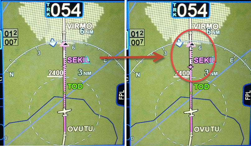 |
|||
|
|||
|
oskrypuch
Senior Member
Joined: 09 Nov 2012 Location: CYFD Status: Offline Points: 3058 |
Post Options
Thanks(0)
Quote Reply
Posted: 20 Jul 2018 at 10:16pm |
||
|
OK, I'm a little out of control, but here is another one, from 2014.
~~~~~~~~~~~~~~~~~~~~~~~~~~~~~~~~~~~~~~~~~~~~~~~~~~~~~~~~~ Feature Request: ADD TOD to flightplan list Subject says it. Why? Well it provides time of arrival at, and time until to, the TOD. Of course, it would be a special non-editable point. Edited by oskrypuch - 20 Jul 2018 at 10:17pm |
|||
|
|||
|
oskrypuch
Senior Member
Joined: 09 Nov 2012 Location: CYFD Status: Offline Points: 3058 |
Post Options
Thanks(0)
Quote Reply
Posted: 20 Jul 2018 at 10:13pm |
||
|
A vertical offset to the computed VNav path would be very handy. Feature Request: add a VNav path indicator This is entirely akin to a glideslope/glidepath indicator, but would instead reflect your relative position as compared to your desired descent (or ascent) profile as reflected in the specified vertical constrains and your specified default VSR. From the graphic of the FIX page request above, note the white linear graphic with the magenta diamond on the right side of the graphic. This is depicting the aircraft "on" VNav path. Besides floating the diamond up/down as this changes, you could also display the number of feet high/low, in comparison to the computed vertical path. This would be a very cool "big boy" feature to add to the IFDs, in concert of course with the Boeing Banana, which we finally have & love! * Orest Edited by oskrypuch - 20 Jul 2018 at 10:14pm |
|||
|
|||
|
oskrypuch
Senior Member
Joined: 09 Nov 2012 Location: CYFD Status: Offline Points: 3058 |
Post Options
Thanks(0)
Quote Reply
Posted: 20 Jul 2018 at 10:10pm |
||
|
There there is this one, would really like to see this. This is from 2012!
~~~~~~~~~~~~~~~~~~~~~~~~~~~~~~~~~~~~~~~~~~~~~~~~~~~~~~~~~~ Feature Request: What about a FIX page? This is a "big boy" feature that allows you to draw on screen radials and circumferences from a waypoint. They are persistent, and not specifically related to your flight plan. (there were several on the MFD page, in my post asking about the BB)
Superb for spatial orientation, especially in busy airspace, or on final approach. At a glance you know you should be close to the OM, or when to drop your speed, or gear or whatever. Also excellent when performing complicated SIDs by hand. You can draw in a DME x.x nm circle where you might need to start a turn as you ascend, and then draw in a VOR radial (like an OBS display, but not linked to the flightplan) that you need to intercept. I routinely draw in a 10nm and 20nm circle around my destination aiport, and then I think 6000 AGL at 20, and 3 at 10, makes sure you are on track. Just add 3000 ft AGL for an approach to an airport in the opposite direction from the active runway.  Very simple user interface, you just specify a radial (optionally), a distance, and the reference waypoint. Edited by oskrypuch - 20 Jul 2018 at 10:11pm |
|||
|
|||
|
oskrypuch
Senior Member
Joined: 09 Nov 2012 Location: CYFD Status: Offline Points: 3058 |
Post Options
Thanks(0)
Quote Reply
Posted: 20 Jul 2018 at 10:07pm |
||
Present Postion would be a great waypoint to have on the fly. To that, let me refresh an idea from a post I made back in 2014 ... ~~~~~~~~~~~~~~~~~~~~~~~~~~~~~~~~~~~~~~~~~~~~~~~~~~~ Yes, you can use the "create user waypoint" dialog to first create all of the below format waypoints, before using them, but when entering a flightplan it would be much faster if you didn't have to sidetrack to that function. Why not just allow them to be entered directly in a special format. Fairly typical in an FMS is the below approach: Crossing radials: JFK190/CYN100 rad/dist: JFK190/25 5nm before a waypoint (eg. HOPCE) already in the flightplan: HOPCE/-5 lat/long, N 47.0, W 080.0 N470W0800 Lat/long in flightplans is becoming more common, especially out west. Being able to enter them directly on the fly, would be much more efficient. Really, the same with all the above. Using the above construct, you also wouldn't litter the user waypoint list with obscure waypoints. Edited by oskrypuch - 20 Jul 2018 at 10:27pm |
|||
|
|||
|
AviSteve
Admin Group 

Joined: 12 Feb 2018 Location: Melbourne, FL Status: Offline Points: 2153 |
Post Options
Thanks(0)
Quote Reply
Posted: 20 Jul 2018 at 7:03pm |
||
Present position holds have been on my short list for a while. As you say, oceanic Lat/Lon waypoint entries and abeam points are more big iron features. We are aware of them but we have quite a few other features that would be implemented before those.
|
|||
|
Steve Lindsley
Avidyne Engineering |
|||
|
|||
|
ansond
Senior Member
Joined: 12 Nov 2009 Location: Austin, Texas Status: Offline Points: 145 |
Post Options
Thanks(0)
Quote Reply
Posted: 20 Jul 2018 at 3:53pm |
||
|
+1 on the Present Position Hold... neat idea.
Doug
|
|||
|
|||
|
palmjet
Newbie

Joined: 19 Jul 2018 Location: Palm Coast Status: Offline Points: 1 |
Post Options
Thanks(0)
Quote Reply
Posted: 20 Jul 2018 at 10:49am |
||
|
Here are some suggestions for features I'm presently missing:
1. A Present position Hold. If you want to program a hold at the Present Position, this cannot be reasonably achieved. It does not happen often that this occurs, certainly not in the USA, but it does happen sometimes as I experienced. Most bigger plane FMS's can do this. First a Waypoint has to be defined at the Present Position after which it is possible to program a holding at that point. By the time you fill in the box with the holding data and then execute it, the aircraft will make a 180 back to the point where the waypoint was created. The right procedure would be to provide an option "PPHOLD" after which a box should open to enter data (a standard hold as default), then after entering and verifying the data the holding waypoint can be created and executed immediately. This would be also great for orbiting. 2. Oceanic waypoint entry. Kind of same problem here. When trying to enter for example N50W035 as a waypoint, the box comes back with "please enter a valid identifier or value", because after entering a few digits it cannot find something in the database. In an oceanic database there are nowadays preprogrammed waypoints like "H5250" (= N52.30W050), but if it is desired to enter the point N50W035, first a waypoint has to be defined, where after the coordinates can be entered and only then that waypoint can be used. This is of course very time consuming in flight. On top of that the defined waypoint can have any given name and therefore has no direct indication for what it stands for. The solution is to have it accept coordinates and then provide a software generated identifier, which must not collide with predefined waypoints, this in line with other FMS systems 3. Abeam Points Suppose you are flying a flightplan with multiple points to a destination: a-b-c-d-e-f-g Flying from "b" to "c" ATC clears direct to "f" so direct to "f" is entered and executed. The IFD then shows a direct line to "f", but the intermediate points "c" "d" and "e" are lost (they are still visible on the FMS page by scrolling back). What really is wanted by the pilot is a perpendicular projection of the previous waypoints on the now direct track to "f", with software generated points on that direct track with names like "Cxxxx" and "Dxxxx" where the x's stand for a distance from the original fix or another value. Now it's possible to follow the progress of the flight better with fuel consumption and time over waypoint. Suggest to program a "soft default" when entering a direct in the flight plan if there will be waypoints skipped, which says "ABM points?". If not touched or pressed, but the 'ENTR" button is pressed, then a direct without abeam points will be executed, otherwise the abeam points will show up after pressing "ENTR". I am aware that these options are not so interesting for VFR use, but as these IFD's are so well designed they can and will be used for advanced operations. Regards, Andre |
|||
|
|||
|
teeth6
Senior Member
Joined: 10 Mar 2014 Status: Offline Points: 741 |
Post Options
Thanks(1)
Quote Reply
Posted: 19 Jul 2018 at 10:33am |
||
|
I think Jimmy said he likes the tabs there all the time
|
|||
|
|||
|
LarryPetro
Groupie

Joined: 03 Nov 2011 Location: Washington, DC Status: Offline Points: 66 |
Post Options
Thanks(0)
Quote Reply
Posted: 19 Jul 2018 at 10:16am |
||
|
Jimmyz80, you could set the user preference that makes the tabs retract after, say, 5 seconds.
|
|||
|
Larry Petro - Columbia 350 @ KFME
|
|||
|
|||
|
jimmyz80
Groupie

Joined: 24 Jul 2016 Location: Folsom, CA Status: Offline Points: 86 |
Post Options
Thanks(0)
Quote Reply
Posted: 18 Jul 2018 at 10:29pm |
||
|
I was reminded in flight today of one minor nit pick I'd love to see fixed in 10.3. When you use the righthand knob to scroll your flight plan all the way to the bottom, the tabs along the bottom of the screen still cover up part of your last waypoint. You have you use your finger to drag the flight plan upward the last little bit, if you want to click on any of the fields towards the bottom of that last waypoint box. Seems like a bug to me, and no I don't want to enable auto-hide of the tabs. I like them there all the time. :)
|
|||
|
2006 Cirrus SR22 - IFD540 IFD440 DFC90 AXP322 MLB100
|
|||
|
|||
|
Catani
Senior Member
Joined: 21 Jan 2016 Status: Offline Points: 362 |
Post Options
Thanks(0)
Quote Reply
Posted: 18 Jul 2018 at 12:25pm |
||
|
In the IFD wifi setup, change the names that indicate what wifi mode the IFD is programmed for.
In wifi setup, change the name "local" to "internal wifi" or just "internal," and change "remote" to "external wifi" or just "external." I think that nomenclature is more intuitive, and will be less likely to require digging into the manual to figure out what the settings mean, and to make sure it's set correctly. As I find myself changing the wifi setting from time to time as I experiment and troubleshoot with different portable devices, it does get easier to remember. But I think it's better not to be quite so puzzled about what "local" and "remote" indicate in the first place.
|
|||
|
|||
|
Cameron
Newbie
Joined: 18 May 2018 Location: Florida Status: Offline Points: 1 |
Post Options
Thanks(0)
Quote Reply
Posted: 11 Jul 2018 at 6:37pm |
||
|
Garmin has had the G5’s on version 5.2 of software for a while, but in some circumstances depending on how an install is done they get a "communication error" annunciation in v5.2. They are aware of these errors, and the only way to solve them short of an entire avionics re-wire for CAN BUS start and end points is to upgrade the G5's to v5.3 software. At the time of this writing, that software is already available for experimental. I have spoken with Garmin reps about 5.3, and that same software should be available for certified aircraft by the end of this month.
There is a problem that occurs when 5.3 is installed that was not there in 5.2 on the Avidyne IFD itself, and that is that once I upgrade to 5.3 on the G5’s (and I suppose the update that it then installs into the GAD 29), the Avidyne then seems to popup an AUX warning that states the "GAD 42 needs servicing". The kicker here is I do not have a GAD 42, and despite the error things work as they should…except now I have a very annoying bright blue light shining in my eyes that I cannot dismiss. My theory on what’s happening here is that Garmin has basically recycled some of their software and hardware components/principals from the GAD 42 and made the GAD 29B with the same concepts, so the IFD thinks it’s there when it’s not. It would be great if we could have a config option where we select if a GAD 42 is present, and if we select no then this warning will simply be ignored and my AUX will stay nice and white. |
|||
|
|||
|
DH82FLYER
Groupie
Joined: 15 Dec 2012 Location: Queensland Status: Offline Points: 88 |
Post Options
Thanks(0)
Quote Reply
Posted: 10 Jul 2018 at 9:27am |
||
|
Suggestion:
Early in the development of the IFD's, it was recognised that the Map Compass Rose significantly contributed to map clutter and was of mixed benefit. This resulted in the option to turn off the Compass Rose. However this option also results in the loss of the "Projected Track Line", a valuable instantaneous track vector, which has many useful functions independent of the Compass Rose eg intercepting the DTK etc. Therefore I (and others I've talked to) believe that it would be advantageous to separate these two items, ie the option to turn off the Compass Rose, thus significantly decluttering the map, but keeping the "Projected Track Line". Thomas
Edited by DH82FLYER - 10 Jul 2018 at 10:01am |
|||
|
|||
|
Awful Charlie
Groupie
Joined: 24 Oct 2013 Location: LFGB Status: Offline Points: 53 |
Post Options
Thanks(0)
Quote Reply
Posted: 19 Jun 2018 at 2:08am |
||
|
+1 on RF legs |
|||
|
|||
|
tommy
Newbie
Joined: 17 May 2018 Location: Australia Status: Offline Points: 9 |
Post Options
Thanks(0)
Quote Reply
Posted: 29 May 2018 at 7:58am |
||
|
I only had IFD440 for a short while so these suggestions might already be in 10.2 if so please excuse my ignorance.
1) When tune for radio by turning the left large knob, can you add an additional tab called "Saved" that lists out the frequency saved in AUX page? 2) options to select and deselect warnings. I have found myself constantly needing to press clear for messages. Thanks |
|||
|
|||
|
ddgates
Senior Member
Joined: 12 Aug 2011 Location: Deer Valley Status: Offline Points: 1100 |
Post Options
Thanks(0)
Quote Reply
Posted: 28 May 2018 at 8:29pm |
||
|
+1 - I know of at least several of us with Aspens, IFDs, and Skytrax units who would like to see interoperability - but suspect that topic is dead given that Navworx is.
Only hope would be that Avi makes reasonable allowance for that and recognizes its Skytrax adopters with its follow on product - and that they make that product interoperable with our Aspens.
|
|||
|
David Gates
|
|||
|
|||
|
nrproces
Senior Member
Joined: 19 Sep 2016 Location: Marion, MT Status: Offline Points: 140 |
Post Options
Thanks(0)
Quote Reply
Posted: 28 May 2018 at 10:43am |
||
|
"I would REALLY like to see some compatibility from my IFD540 /
Skytrax to my Aspen so I can see ADS-B weather/traffic on it." I agree with the "cubed root" above, I would like my Aspen system to be able to take advantage of the great stuff my 540 has....JMO
|
|||
|
Sauce
|
|||
|
|||
|
CubedRoot
Groupie
Joined: 06 May 2018 Location: KFGU Status: Offline Points: 88 |
Post Options
Thanks(0)
Quote Reply
Posted: 28 May 2018 at 1:06am |
||
|
I would REALLY like to see some compatibility from my IFD540 / Skytrax to my Aspen so I can see ADS-B weather/traffic on it.
|
|||
|
|||
|
msflygood
Newbie

Joined: 30 Nov 2015 Location: KSBA Status: Offline Points: 4 |
Post Options
Thanks(0)
Quote Reply
Posted: 28 May 2018 at 12:30am |
||
|
Please add a User Selectable FIRST Chart View to 10.3. Right now, the ALL view comes up last requiring me to push the VIEW button 4 times, which is annoying. Given the great slewing features of the 540, I'd prefer to see the whole chart (ALL) as the FIRST view that comes up so I can quickly look at what I want to see, be it the minimums sections, or the profile, etc. After the ALL view, then, you can rotate through the other options. If this is user selectable, then everyone is happy.
|
|||
|
|||
|
AviSteve
Admin Group
Joined: 12 Feb 2018 Location: Melbourne, FL Status: Offline Points: 2153 |
Post Options
Thanks(0)
Quote Reply
Posted: 19 May 2018 at 9:32am |
||
We have a limited allowable color pallette in that arena. We can take a look, but it would likely be in the lower half of the priority list.
|
|||
|
Steve Lindsley
Avidyne Engineering |
|||
|
|||
|
jhbehrens
Senior Member
Joined: 15 Dec 2012 Location: Netherlands Status: Offline Points: 122 |
Post Options
Thanks(0)
Quote Reply
Posted: 19 May 2018 at 5:07am |
||
|
Traffic and obstacles look too similar on the map with the same blue colour and the same font for altitude. Close to airports they often overlap and I can’t see which is which. Can the fonts be made thinner/smaller? Can the colours be made even slightly different?
|
|||
|
|||
|
94S
Senior Member
Joined: 06 Mar 2014 Location: Bismarck, ND Status: Offline Points: 162 |
Post Options
Thanks(0)
Quote Reply
Posted: 17 May 2018 at 9:16am |
||
|
I don't use the BTKB. For me using the IFD is easy enough (except for the fact that I have to tap inside the already active text field to bring up the onscreen keyboard), and my yoke is occupied by my iPad. From the first time I saw the IFD, way back before it was certified, I've thought the onscreen keyboard is one of the many things that set it apart from the knob twisting on G's products. I use the knob twisting when necessary in turbulence, but the onscreen keyboard is my first preference. I just wish it would automatically come up when I'm in a text entry field so I don't have to tap the screen to get it.
|
|||
|
|||
|
oskrypuch
Senior Member
Joined: 09 Nov 2012 Location: CYFD Status: Offline Points: 3058 |
Post Options
Thanks(0)
Quote Reply
Posted: 16 May 2018 at 6:33pm |
||
|
I discovered this quick KB waypoint entry as well, quite by accident, and love it. Use it all the time.
* Orest |
|||
|
|||
|
chflyer
Senior Member
Joined: 24 Jan 2013 Location: LSZK Status: Offline Points: 1022 |
Post Options
Thanks(0)
Quote Reply
Posted: 16 May 2018 at 6:17pm |
||
There is a neat way to sort of solve this today, using the KB. I've discovered (I can't find this anywhere in the manual), that if you start typing a waypoint on the KB, the first key struck opens the new waypoint entry mode along with the entry text box (and the on-screen keyboard). So 1 single keystroke on the KB gets you to where you want to be as you describe above, with the first letter of the waypoint you want already entered ..... really neat!! Like Orest, I also have my KB mounted on the yoke, so this is super simple with one hand without even removing it from the yoke or having to reach over to the IFD. If the proposed waypoint happens to be the desired one, then the 2nd keystroke on the KB is the enter key. Two strokes and done. Multiple waypoints can be entered very quickly this way.
Edited by chflyer - 16 May 2018 at 6:21pm |
|||
|
Vince
|
|||
|
|||
|
MysticCobra
Senior Member

Joined: 29 Jan 2013 Status: Offline Points: 649 |
Post Options
Thanks(0)
Quote Reply
Posted: 09 May 2018 at 8:09am |
||
Too many gizmos, not enough room. I don't need the keyboard frequently enough to mount it somewhere where it's always handy--there just isn't a spot for it that wouldn't displace something else I use more frequently. The yoke is reserved for a tablet that gets far more frequent use. I do use the keyboard, but generally only at the start of a flight when I'm building the flight plan. After that, it gets tucked in a pocket and mostly isn't used again until the next flight starts. (But I do really like having it for that usage.)
|
|||
|
|||
|
HenryM
Senior Member
Joined: 13 Oct 2017 Location: Texas Status: Offline Points: 486 |
Post Options
Thanks(0)
Quote Reply
Posted: 08 May 2018 at 9:27pm |
||
|
I got the keyboard for the IFD-540 last October. I had to register the IFD, which the previous owner had not done. I was not an early adopter. I think the IFD-440might have required a separate Bluetooth unlock.
|
|||
|
|||
|
Post Reply
|
Page <1 56789> |
 Tweet
Tweet
|
| Forum Jump | Forum Permissions You cannot post new topics in this forum You cannot reply to topics in this forum You cannot delete your posts in this forum You cannot edit your posts in this forum You cannot create polls in this forum You cannot vote in polls in this forum |


 Topic Options
 oskrypuch wrote: