
|
IFD540 Screen Question |
Post Reply 
|
| Author | |
donemory 
Groupie 

Joined: 18 Feb 2019 Location: Medina, OH Status: Offline Points: 44 |
 Post Options Post Options
") Thanks(0) Thanks(0)
 Quote Reply Quote Reply
 Topic: IFD540 Screen Question Topic: IFD540 Screen QuestionPosted: 21 Apr 2019 at 1:14pm |
|
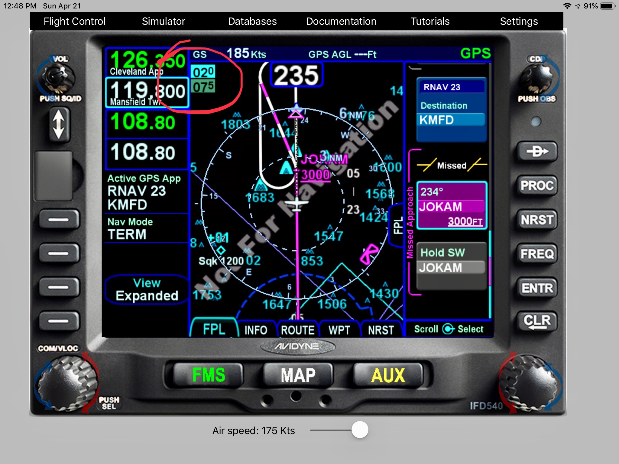
Can someone let me know what the 2 numbers I have circled in RED on the IFD540 screen in the attached pic are (mean)? My assumption it has something to do with altitudes but I am guessing. Thanks for the help.
|
|
|
Don
|
|
 |
|
|
donemory
Groupie
Joined: 18 Feb 2019 Location: Medina, OH Status: Offline Points: 44 |
Post Options
Thanks(0)
Quote Reply
Posted: 21 Apr 2019 at 1:18pm |
|
See pic below...
Edited by donemory - 21 Apr 2019 at 1:45pm |
|
|
Don
|
|
|
|
|
donemory
Groupie
Joined: 18 Feb 2019 Location: Medina, OH Status: Offline Points: 44 |
Post Options
Thanks(0)
Quote Reply
Posted: 21 Apr 2019 at 1:37pm |
 Edited by donemory - 21 Apr 2019 at 1:43pm |
|
|
Don
|
|
|
|
|
chflyer
Senior Member 

Joined: 24 Jan 2013 Location: LSZK Status: Offline Points: 1022 |
Post Options
Thanks(0)
Quote Reply
Posted: 21 Apr 2019 at 2:27pm |
|
Check the IFD540 PG Map pages section, page 3-8.
Basically the split map display in the FMS section should be the same as described above for the Map pages. What seems a bit strange is that you should see 3 altitudes, 2 for the lowest and highest terrain on the map and the top one for obstacles clearance. All the screenshots in the FMS section of the PG show the 3 altitudes. Perhaps what you are seeing is somehow related to being a sim display. I notice that your GPS altitude is showing ---, so perhaps that is why the lower altitude is not being displayed. Edited by chflyer - 21 Apr 2019 at 2:40pm |
|
|
Vince
|
|
|
|
|
oskrypuch
Senior Member
Joined: 09 Nov 2012 Location: CYFD Status: Offline Points: 3058 |
Post Options
Thanks(0)
Quote Reply
Posted: 21 Apr 2019 at 2:58pm |
|
The other thing that is puzzling, is that the top number should always be larger than the 2nd from the top, it can't be lower as it represents the higher elevation of an obstacle above the terrain. If they are the same, then these two are merged into one. There is no terrain scale drawn at all, nor a lower number. Perhaps terrain is not installed, or something? * Orest |
|
|
|
|
chflyer
Senior Member
Joined: 24 Jan 2013 Location: LSZK Status: Offline Points: 1022 |
Post Options
Thanks(0)
Quote Reply
Posted: 21 Apr 2019 at 7:31pm |
|
Can one configure the sim without terrain?
|
|
|
Vince
|
|
|
|
|
AviSteve
Admin Group 

Joined: 12 Feb 2018 Location: Melbourne, FL Status: Offline Points: 2153 |
Post Options
Thanks(0)
Quote Reply
Posted: 21 Apr 2019 at 9:53pm |
|
Definitely something weird there. I just tried it and the elevation showed 1000 to 1600 with the highest obstacle at 2000. I wouldn't expect it ever to look like your screenshot, but my guess is that it's something to do with the terrain database as has been suggested. Make sure you have North America terrain loaded.
|
|
|
Steve Lindsley
Avidyne Engineering |
|
|
|
|
dmtidler
Senior Member

Joined: 12 Feb 2016 Location: USA Status: Online Points: 616 |
Post Options
Thanks(0)
Quote Reply
Posted: 21 Apr 2019 at 10:10pm |
|
I agree, the black background on the map display also may indicate a missing North American terrain database.
|
|
|
|
|
Post Reply
|
|
 Tweet
Tweet
|
| Forum Jump | Forum Permissions You cannot post new topics in this forum You cannot reply to topics in this forum You cannot delete your posts in this forum You cannot edit your posts in this forum You cannot create polls in this forum You cannot vote in polls in this forum |


 Topic Options