
|
strange approach |
Post Reply 
|
| Author | |
luchetto 
Senior Member 
Joined: 10 Dec 2015 Location: Switzerland Status: Offline Points: 119 |
 Post Options Post Options
") Thanks(0) Thanks(0)
 Quote Reply Quote Reply
 Topic: strange approach Topic: strange approachPosted: 30 Dec 2015 at 3:27am |
|
I will soon get my 540/440 combo and am playing around with the sim so bear with me if I bombard you with questions that might have come up already.
I am based in Zurich hence my examples are all somewhere in Europe. I had the sim load and fly the ILS 28 Y into LIMJ and as you can see from the picture the box generates another 360 turn just before the final approach segment. The Sim will also fly this additional 360. There is nothing like this on the Jepp Chart ( Varap point) which is also attached so I wonder why this is and if it is just a Sim bug. Thanks Placido 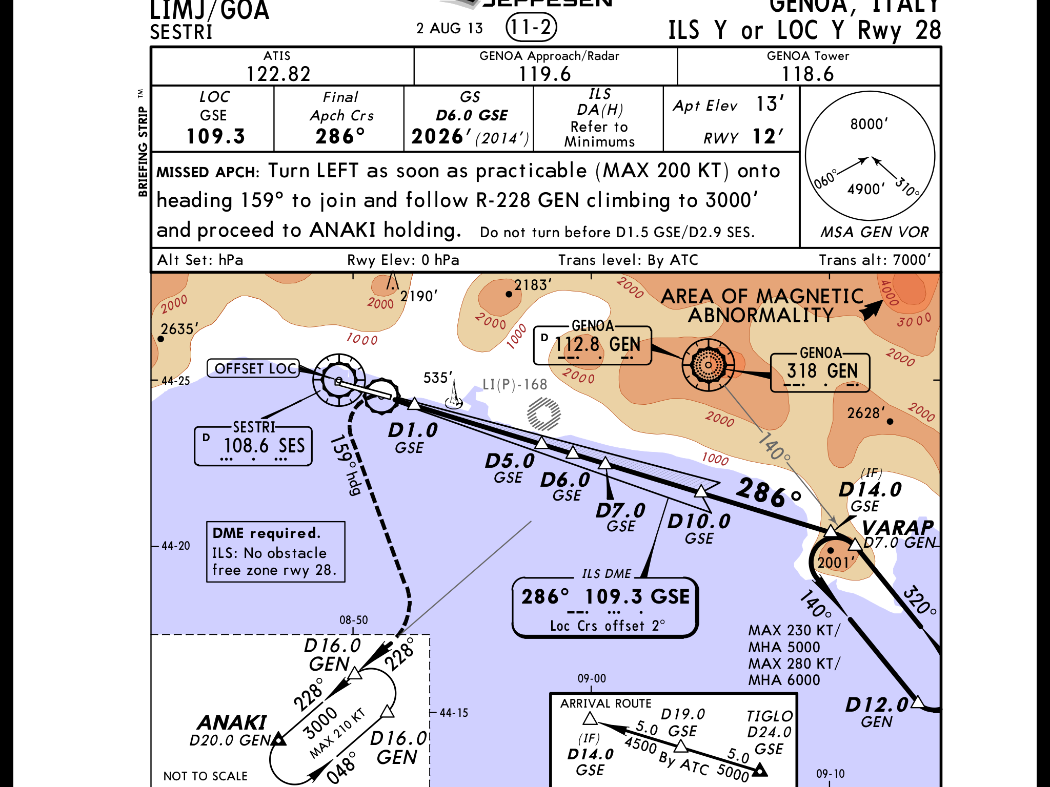
|
|
 |
|
|
luchetto
Senior Member
Joined: 10 Dec 2015 Location: Switzerland Status: Offline Points: 119 |
Post Options
Thanks(0)
Quote Reply
Posted: 30 Dec 2015 at 3:38am |
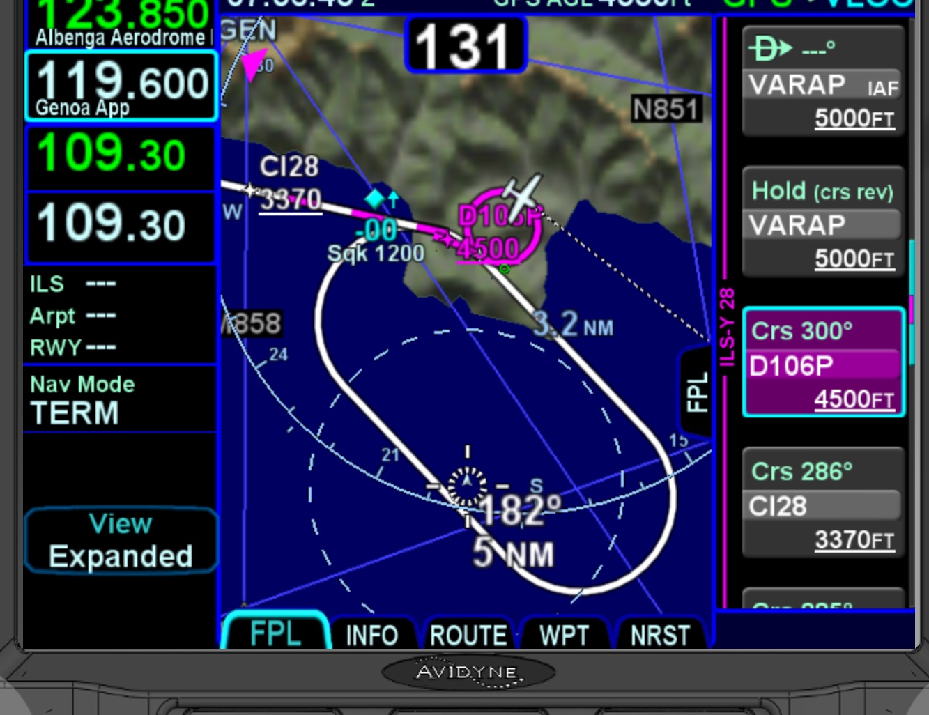 here comes the Sim screenshot |
|
|
|
|
AviJake
Admin Group 
Joined: 26 Mar 2009 Location: Lincoln MA Status: Offline Points: 2815 |
Post Options
Thanks(0)
Quote Reply
Posted: 30 Dec 2015 at 11:26am |
|
We'll have a look when we're back in the lab in a few days.
|
|
|
Steve Jacobson
sjacobson@avidyne.com |
|
|
|
|
luchetto
Senior Member
Joined: 10 Dec 2015 Location: Switzerland Status: Offline Points: 119 |
Post Options
Thanks(0)
Quote Reply
Posted: 06 Jan 2016 at 4:18pm |
|
Steve were you able to look into this?
|
|
|
|
|
AviJake
Admin Group
Joined: 26 Mar 2009 Location: Lincoln MA Status: Offline Points: 2815 |
Post Options
Thanks(0)
Quote Reply
Posted: 06 Jan 2016 at 5:20pm |
|
Yes.
The culprit in this approach is the leg from VARAP to D106N (which is the point 14nm from GSE along the 106 radial - reciprocal of the 286 degree inbound course). In his picture, it's D106P, but you must be using an older database cycle. That leg is defined as a DF (Direct To Fix) leg, which does not define an inbound course. So the FMS will try to construct a path from the aircraft position to that point right as VARAP is sequenced. The path consists of an entry turn and a geodesic path to the point. The entry turn is computed using the current aircraft course as the starting direction. The end of the turn is computed as the point along the turn where the geodesic path is tangent to the turn. *If* the aircraft current course is within two degrees of the course to the waypoint, then the system won't bother generating the entry turn.
In this case, if the aircraft is on path at the hold fix, its course will be 320°. The course from the hold fix to D106N is ideally 310°, but depending upon the aircraft course when the leg sequences, it could be off of that. In your screen shots, it is actually 300°. So even in the ideal situation, the difference between the hold inbound course and the course to D106N is more than the two degrees, so the system tries to compute an entry turn and then a geodesic to D106N. Because the distance to D106N is so short (roughly a half mile), the system cannot compute the entry turn and a geodesic leg before getting to the waypoint. So, it generates a nice big circle in order to hit the waypoint. We're looking at some improvements we can make in the next release. |
|
|
Steve Jacobson
sjacobson@avidyne.com |
|
|
|
|
luchetto
Senior Member
Joined: 10 Dec 2015 Location: Switzerland Status: Offline Points: 119 |
Post Options
Thanks(0)
Quote Reply
Posted: 06 Jan 2016 at 5:36pm |
|
Ok, sounds very complicated but it seems it raised an issue to correct. BTW why are the intermediate fix designations not like on the plate? and how could I update the database on the sim?
|
|
|
|
|
AviJake
Admin Group
Joined: 26 Mar 2009 Location: Lincoln MA Status: Offline Points: 2815 |
Post Options
Thanks(0)
Quote Reply
Posted: 16 Jan 2016 at 11:11am |
|
After a thorough database search, it turns out that this is the only approach in the global Jepp database that has the HF-DF leg combination. We are not planning on making any coding changes to address this special condition at this time.
|
|
|
Steve Jacobson
sjacobson@avidyne.com |
|
|
|
|
n7ifr
Senior Member

Joined: 05 Aug 2013 Location: Scottsdale, Az Status: Offline Points: 470 |
Post Options
Thanks(0)
Quote Reply
Posted: 16 Jan 2016 at 11:27am |
|
Steve,
Can you tell us if Jepp & Avidyne have considered adding "Low Enroute" charting to the Jepp ChartView 540-subscriptions? This and having Track-Up in Jepp charts/airports and automatic Apt Diagram pop-up upon landing would be great additions... Thanks. Tom Wolf
|
|
|
|
|
AviJake
Admin Group
Joined: 26 Mar 2009 Location: Lincoln MA Status: Offline Points: 2815 |
Post Options
Thanks(0)
Quote Reply
Posted: 16 Jan 2016 at 11:37am |
|
Yes, we have. It has resulted in our head spinning due to the amount of effort and complexity it adds. We keep kicking that enroute chart support can down the road.
Track Up charts is also called Geo-referenced charts. The database is trying to be updated to support but it's a giant undertaking and will take a long time (not sure how to define "long" here). One note on the auto airport diagram pop up - if you were flying an approach to the airport and had it up on Chart tab, it will auto toggle to the airport diagram on roll out. |
|
|
Steve Jacobson
sjacobson@avidyne.com |
|
|
|
|
n7ifr
Senior Member
Joined: 05 Aug 2013 Location: Scottsdale, Az Status: Offline Points: 470 |
Post Options
Thanks(0)
Quote Reply
Posted: 16 Jan 2016 at 12:02pm |
|
One note on the auto airport diagram pop up - if you were flying an approach to the airport and had it up on Chart tab, it will auto toggle to the airport diagram on roll out.
Did not realize this feature... Geo-referencing both approach chart and Apt diagrams would be a major plus. Thanks. Tom Wolf
|
|
|
|
|
Post Reply
|
|
 Tweet
Tweet
|
| Forum Jump | Forum Permissions You cannot post new topics in this forum You cannot reply to topics in this forum You cannot delete your posts in this forum You cannot edit your posts in this forum You cannot create polls in this forum You cannot vote in polls in this forum |


 Topic Options