
|
Approach waypoint missing and wishlist confusion |
Post Reply 
|
| Author | ||||
brou0040 
Senior Member 
Joined: 13 Dec 2012 Location: KIYK Status: Offline Points: 722 |
 Post Options Post Options
") Thanks(0) Thanks(0)
 Quote Reply Quote Reply
 Topic: Approach waypoint missing and wishlist confusion Topic: Approach waypoint missing and wishlist confusionPosted: 21 Feb 2016 at 12:13pm |
|||
|
I was flying the PMD LOC 25 yesterday and noticed that SKKEE was missing from the database. We were simulating a GS failure so I was expecting to use that intersection to verify my stepdown and it wasn't in the database.
There are two sets of LOC minimums. If you can't identify SKKEE, then you stay at 3500 and drive to the MAP, but if you can identify SKKEE, then you can descend down to 2900. I know I could have set up the second nav radio to identify SKKEE, but why isn't it in the database? Since PMD VOR is not part of the approach, I don't have any easy data showing DME to it to identify it that way. Although the MAP and the PMD VOR are near each other, using the DME to the MAP isn't correct. I like to stay on the full page FMS tab when flying an approach and I see that I can hit the NRST button twice to pull up the nearest VOR, which has distance information, but then I have to go back to the FMS page, where it is no longer full page and I have to re-expand it every time I check. Is the answer to this that not all of these DME approach points are in the Jepp database and that won't change and that there is a wishlist item for DME to a selected point to work around this? I tried finding a wishlist description and a response stating "added to the candidate list", but didn't find it. I wouldn't expect Avidyne to provide a list of features per software updates, dates, or sensitive features, but is there a compromise where you could post a list of user requested features that made the candidate list and put a sticky on it so we look there first to see if this has already been considered?
|
||||
 |
||||
|
chflyer
Senior Member

Joined: 24 Jan 2013 Location: LSZK Status: Offline Points: 1056 |
Post Options
Thanks(0)
Quote Reply
Posted: 21 Feb 2016 at 4:47pm |
|||
|
What response did Jepp make to the missing SKKEE, as the navdata provider?
|
||||
|
Vince
|
||||
|
||||
|
PA20Pacer
Senior Member
Joined: 07 Mar 2012 Location: Illinois (LL22) Status: Offline Points: 161 |
Post Options
Thanks(0)
Quote Reply
Posted: 22 Feb 2016 at 8:30am |
|||
|
The SKKEE waypoint can be identified by the 3.0 mile distance from the MAP, as shown on the plan view. I have noticed that these intermediate stepdown waypoints are often not part of the loaded approach sequence.
Regards, Bob
|
||||
|
Bob Siegfried, II
Brookeridge Airpark (LL22) Downers Grove, IL |
||||
|
||||
|
brou0040
Senior Member
Joined: 13 Dec 2012 Location: KIYK Status: Offline Points: 722 |
Post Options
Thanks(0)
Quote Reply
Posted: 22 Feb 2016 at 9:45am |
|||
I disagree, but I'd like to learn if I'm wrong, please explain. My understanding is that the DME is based on the PMD VOR and the MAP and VOR are not collocated. My gut says this has been covered before in the forum, but I couldn't find it.
|
||||
|
||||
|
pburger
Senior Member
Joined: 26 Dec 2013 Location: United States Status: Offline Points: 406 |
Post Options
Thanks(0)
Quote Reply
Posted: 22 Feb 2016 at 11:14am |
|||
|
I agree with PA20Pacer that SKKEE can be identified by the 3.0nm distance from the MAP as depicted on the profile view. However, I'm not sure if that is legal. (Probably is, but I'm no expert).
This is not a GPS approach, but rather an ILS - or in this case a LOC. The approach requires either 2 VORs or DME to use SKKEE. With two VORs you can use the crossing radial from EDW, and with DME, you can tune it to PMD and use the 2.5 nm point as depicted on the profile view. I know there are all sorts of exceptions when GPS can be used in lieu of DME, but I'm not sure this is one of them (someone out there knows). You wouldn't be using the GPS to actually measure the 2.5 nm distance from PMD as is described on the profile, but rather would be using the GPS to measure the distance from the MAP. Is it safe? I would say yes. I used to fly a private LNAV approach that had a step-down fix. My old Garmin GNC-300XL did not include the step-down fix, so I identified it via the distance from the MAP. But that was a GPS approach, where I was supposed to be relying on the GPS.
Edited by pburger - 22 Feb 2016 at 11:16am |
||||
|
||||
|
Catani
Senior Member
Joined: 21 Jan 2016 Status: Offline Points: 362 |
Post Options
Thanks(0)
Quote Reply
Posted: 22 Feb 2016 at 3:44pm |
|||
|
SKKEE is a point along the final approach course, located by either a EDW radial or DME from PMD, neither of which navaid is part of the approach. If you have DME, you can tune the PMD VOR on your second nav radio, and read off the 2.5 PMD DME to identify SKKEE (SKKEE is NOT identified by distance from the MAP). Alternatively, if you don't have DME, you can fix SKKEE by tuning EDW on your second nav radio and noting when crossing the 199 radial. Having identified SKKEE with one of these two techniques, you could descend to the lower minima. In either case, your #1 nav radio is tuned to the LOC, and your #2 nav radio is tuned to either PMD or EDW, as equipment and desires dictate. The GPS is not involved in either the LOC final approach guidance or fixing SKKEE in these scenarios and can be disregarded while on the final approach course, until you are ready to fly the MAP segment.
Since the rules don't allow GPS to be used to substitute for final approach guidance on NDB, VOR, ILS or LOC procedures inside the FAF or glidepath intercept, I don't believe GPS can substitute for fixing SKKEE as a point in space, since that would require having the GPS also substitute for the LOC final approach guidance in order to identify the intersection. However, GPS can substitute for DME fixes, but only if the fix or facility is in the database. Here, SKKEE is not in the database, again probably because the location of the fix is determined not only by DME, but also by the LOC final approach guidance for which the GPS is not a legal substitute. I haven't had time to check other approaches, but I suspect that GPS cannot be used to locate a step down fix on a LOC approach if the fix is determined by the intersection of a radial and the final approach course, or if it is determined by DME from a VORTAC that is not part of the final approach guidance, because to do so it would have to decide whether you are on the final approach course or not. Since this is not approved, it makes sense to me why Jepp would not attempt to put such fixes in the database. [Note that a step down fix defined by DME incorporated within a VORTAC or ILS/LOC facility that is providing final approach guidance may well be in the GPS database, because then VORTAC or ILS/LOC facility is part of the approach, and the GPS would be used as a DME substitute simply to read off the DME from that facility. You would still be flying the raw data final approach course guidance while the GPS ticks off the DME readout and has the specified distance as a named fix in the database.] But it seems to me, for this LOC 25 approach into KPMD, you could use the GPS to determine either your distance from PMD or what EDW radial you are on at any point in time, since both of those facilities are in the GPS database. This would be especially useful if you had no DME radio or no second nav radio. For example: you could set up the LOC approach using the #1 nav radio, and set up the GPS with the PMD VORTAC as the next fix (assuming PMD is in the database, which as a VORTAC it most likely will be - if not, this won't work). GPS can substitute for DME when the facility (here, PMD VORTAC) is in the database. Then, as you fly down the localizer, when the GPS shows it is 2.5NM from PMD, you are at SKKEE and can descend to the lower minimums. Just like you would do if you had DME in the aircraft and tuned it to the PMD VORTAC. It also seems to me you could use the GPS to determine when, while following the LOC final approach guidance, you are crossing the EDW 199 radial. You would put EDW as a fix in the GPS, and monitor the relative bearing between you and the what the GPS says is the location of EDW. When the GPS says you are crossing that radial, you have identified SKKEE and can descend. In either case, while SKKEE may not have been in the GPS database for reasons stated, you have two options for using the GPS to locate SKKEE and take advantage of the lower minimums. Now, of course, using the GPS in this way prevents you from loading the approach into it, since you're loading EDW or PMD VORTACS instead. So you'd need a second GPS to do this, if you wanted to use GPS guidance for the missed approach segment. Note how much simpler this approach would be, with or without GPS, if the LOC facility incorporated the DME instead of relying upon some other VORTAC not part of the approach. Then you would only need one nav radio receiver with DME to fly the approach and identify SKKEE. Or if you didn't have a DME radio, I suspect SKKEE would be in the GPS database.
|
||||
|
||||
|
mfb
Senior Member
Joined: 20 Dec 2014 Location: KATW Status: Offline Points: 293 |
Post Options
Thanks(0)
Quote Reply
Posted: 22 Feb 2016 at 5:31pm |
|||
|
This is a very interesting discussion, especially your message about the legalities of substituting GPS for DME.
However, it's all a bit academic in this particular case. If you're trying to use your IFD540 GPS to identify SKEE on the KPMD LOC 25 approach, presumably the GPS is working although the ILS may not be. In that case, it would be a better to use the RNAV GPS 25 LPV or LNAV approaches, which have lower minimums. And the GPS 25 approach plate identifies SKKEE as 3 NM from the runway. It's a stepdown fix. One would think it's the same SKKEE as the one that's on the LOC 25 plate. But transferring a GPS fix to a localizer approach is probably not a proper thing to do. Mike
|
||||
|
||||
|
BobsV35B
Senior Member

Joined: 24 Aug 2011 Location: Downers Grove, Status: Offline Points: 131 |
Post Options
Thanks(0)
Quote Reply
Posted: 22 Feb 2016 at 7:36pm |
|||
|
To mfb,
The IFR approved GPS is always available as a substitute for a DME. As long as the waypoint is printed on a chart and available in the GPS database it is absolutely legal. Check the AIM. In fact, most IFR Approved FMS units have the same capability. Happy Skies, Old Bob
|
||||
|
Old Bob, Ancient Aviator
|
||||
|
||||
|
brou0040
Senior Member
Joined: 13 Dec 2012 Location: KIYK Status: Offline Points: 722 |
Post Options
Thanks(0)
Quote Reply
Posted: 22 Feb 2016 at 10:54pm |
|||
|
I understand the final approach needs to use the ILS signal, not GPS. I didn't realize why SKKEE couldn't be in the flight plan based on DME from PMD while your guidance is still based on the ILS, but I can see how that could create a conflict where it would be in the flight plan with no horizontal guidance.
I think this is already a feature request, but I can't find it. I'd like to request a datablock that contains waypoint, radial, and DME. It would not be tied to the flight plan so I could use a navaid not on the flight plan. You press the datablock to pop-up a data entry block to enter the waypoint. I thought this was earlier requested with respect to flying a hold so you know how far you are from the fix rather than the remaining distance around the track. In this case, I'd enter the PMD VOR into the datablock and could identify SKKEE by 2.5 nmi reading while still navigating via the ILS. Because I thought this was already a feature request that I can't find using the search feature, I was wondering if there could be a posted list of candidate features with a sticky.
Edited by brou0040 - 22 Feb 2016 at 11:07pm |
||||
|
||||
|
PA20Pacer
Senior Member
Joined: 07 Mar 2012 Location: Illinois (LL22) Status: Offline Points: 161 |
Post Options
Thanks(0)
Quote Reply
Posted: 23 Feb 2016 at 8:21am |
|||
|
Hi Brou00400-
If my memory is correct, the feature request that you describe relative to the distance measurement in a hold is a "direct to next waypoint" datablock. I hope that this will be in 10.2.0.0. The additional feature you request, a "direct to a user-selected waypoint" datablock is good, and I would endorse that request. Regarding the previous discussion, it is unquestionably legal to use GPS in lieu of DME to identify a waypoint on an ILS approach, as long as that waypoint can be identified by a distance reference to a point in the database. I would argue that the MAP qualifies as a point in the database, and the distance from SKKEE to the MAP is clearly shown on the profile view. Regards, Bob
|
||||
|
Bob Siegfried, II
Brookeridge Airpark (LL22) Downers Grove, IL |
||||
|
||||
|
Catani
Senior Member
Joined: 21 Jan 2016 Status: Offline Points: 362 |
Post Options
Thanks(0)
Quote Reply
Posted: 23 Feb 2016 at 4:28pm |
|||
Not sure what the Jepp chart shows, but the government chart in ForeFlight for the LOC 25 at KPMD to me clearly show that SKKEE is defined as 2.5 DME from the PMD VORTAC (same for AMANE at 9.6 DME). Additionally, since this is not a GPS approach, any DME figures on the chart would of necessity be measured from DME transmitters as detected by an onboard DME receiver, not some imaginary non-transmitting MAP. While there may be some other approach where the MAP is co-located with a 0.0 DME point, from the airport diagram on this chart it appears they are not - you pass the PMD VORTAC before reaching the MAP at the approach end of Runway 25. Of course, there's nothing wrong with going missed before the MAP if you want to.
|
||||
|
||||
|
FlyingCOham
Senior Member

Joined: 30 Oct 2015 Location: COS (KFLY) Status: Offline Points: 125 |
Post Options
Thanks(0)
Quote Reply
Posted: 23 Feb 2016 at 7:44pm |
|||
|
According to FAA Order JO 7350.9E (2/4/16, page P-A-325), SKKEE is defined as (emphasis added):
"SKKEE CA EDW*C*198.80 PMD*C*/2.54 PMD*LS*071.20 34-38-09.8900N 118-00-46.0800W" Therefore, there is no reason it can't/shouldn't be included in a NAV database. |
||||
|
Jim Patton
|
||||
|
||||
|
brou0040
Senior Member
Joined: 13 Dec 2012 Location: KIYK Status: Offline Points: 722 |
Post Options
Thanks(0)
Quote Reply
Posted: 23 Feb 2016 at 8:53pm |
|||
After thinking about this a bit more, I disagree with myself. I don't believe there would be an issue. SKKEE being in the flight plan would be no different than the MAP being in the flight plan. Both are based on the ILS horizontal signal rather than GPS. Since SKKEE is in the database as pointed out by another poster, I'm back to wondering why is it not being included in the flight plan for this approach? I know there have been discussions regarding removing/adding points into an approach, I suppose this could be another way to handle this specific approach, but I still think the DME/RAD to waypoint is a useful feature.
Edited by brou0040 - 23 Feb 2016 at 8:55pm |
||||
|
||||
|
richholt
Newbie 
Joined: 17 Aug 2015 Location: Sierra Vista AZ Status: Offline Points: 5 |
Post Options
Thanks(0)
Quote Reply
Posted: 24 Feb 2016 at 11:45am |
|||
|
If you look for SKKEE using Jeppesen Mobile Flite Deck you will find it is defined as a Terminal Fix at N 34 38.2 W 118.00.8 . So apparently in the Jeppesen database SKKEE is defined as a GPS fix unrelated to a DME distance from the PMD VOR.
|
||||
|
Richard
|
||||
|
||||
|
94S
Senior Member
Joined: 06 Mar 2014 Location: Bismarck, ND Status: Offline Points: 164 |
Post Options
Thanks(0)
Quote Reply
Posted: 24 Feb 2016 at 2:21pm |
|||
|
"Additionally, since this is not a GPS approach, any DME figures on the
chart would of necessity be measured from DME transmitters as detected
by an onboard DME receiver,..."
Catani, I don't think that is correct, at least not in the US. In my humble interpretation of AC 90-108 (Change 1), an IFR certified GPS, aka "Suitable RNAV System", can be substituted for DME distance anytime, anywhere; Paragraph 7.a.(1). Where it cannot be used, in regards to this conversation about the PMD ILS/LOC25 approach, is for the "lateral" guidance along the localizer coarse on a localizer based approach; Paragraph 8.c. It also cannot be used for the lateral guidance along the Final Approach Segment of a VOR or NDB based approach; Paragraph 8.b, or when the procedure is otherwise NOTAMed; Paragraph 8.a. Nothing in paragraph 8, other than a possible NOTAM, forbids the GPS distance from substituting for DME distance on these types of approaches. AC 90-108 Change 1 can be found here, http://www.faa.gov/documentLibrary/media/Advisory_Circular/AC_90-108_Chg_1.pdf Again, this is just my interpretation. If there are any CFIIs or FAA examiners on the forum that would like to confirm or correct this, please do. As for brou0040's original post, I checked the KBIS ILS/LOC13 approach here in my neighborhood. It also has a step-down fix JABVU that is not listed in the FMS when this approach is loaded in the IFD. My guess is that these types of fixes must be identified by distance from the station, either DME or GPS derived. It doesn't make alot of sense because I can enter D> JABVU or D> SKKEE by hitting the Direct To button and typing in the identifier. So obviously these fixes are in the database. I suppose there is some FAA reg that spells out what must and must not be included in an approach when loaded in the unit. What would be nice to see in the NAV frequency boxes, next to the decoded station ID, is the distance to the station for both the active and standby nav frequencies. That way if you don't have a DME and are navigating along the localizer with the active frequency, you would still have the distance to the station in the standby slot that could be used to identify fixes such as SKKEE. Or, for those that don't have the nav frequency data blocks displayed in their setup, a separate data block that can be located in any data block position that shows this information. David |
||||
|
||||
|
tony
Senior Member

Joined: 06 Dec 2011 Location: Atlanta Status: Offline Points: 466 |
Post Options
Thanks(0)
Quote Reply
Posted: 24 Feb 2016 at 4:14pm |
|||
|
So 90-108 says "within the United States (U.S.) National
Airspace System (NAS)". I don't think the rest of the world is allowed to do this.
|
||||
|
||||
|
Catani
Senior Member
Joined: 21 Jan 2016 Status: Offline Points: 362 |
Post Options
Thanks(0)
Quote Reply
Posted: 24 Feb 2016 at 9:40pm |
|||
David: think about it. There are GA airplanes flying around with nothing but steam gauges, navcoms, and DMEs, with no GPS equipment. They can obviously fly the LOC 25 approach without GPS equipment, identify SKKEE by LOC and DME, and descend when reaching. The chart, designed to be flown without GPS equipment, has DME distances on the chart that can only mean distances "measured from DME transmiters as detected by an onboard DME receiver." Planes without GPS but with DME do that kind of thing all the time, both in the US and internationally.
True, so long as the waypoint or facility is in the GPS database. See Instrument Flying Handbook, pg 9-27, "GPS Substitution for ADF or DME" para.3; see also AC 90-108, para 9.b.(1). Here, the PMD VOR would be in the database, so it would be acceptable for a pilot with a VOR/LOC nav radio but no DME to use his GPS with PMD VOR set as the next GPS waypoint to determine when he is 2.5 DME from the PMD VOR. If he's on the LOC course as determined by his nav radio when his GPS says he's 2.5 DME from PMD, he's properly identified SKKEE and can descend. The GPS has legally substituted for the missing DME radio, but it can't legally be used to tell if he's on the localizer course.
|
||||
|
||||
|
brou0040
Senior Member
Joined: 13 Dec 2012 Location: KIYK Status: Offline Points: 722 |
Post Options
Thanks(0)
Quote Reply
Posted: 24 Feb 2016 at 10:53pm |
|||
That reminds me... Another reason for a list of candidate features.
Edited by brou0040 - 24 Feb 2016 at 10:54pm |
||||
|
||||
|
Catani
Senior Member
Joined: 21 Jan 2016 Status: Offline Points: 362 |
Post Options
Thanks(0)
Quote Reply
Posted: 25 Feb 2016 at 2:10am |
|||
No doubt Jepp could easily included it in the GPS database's LOC 25 approach procedure, the geographical location of SKKEE to a cartographer or TERPS designer is no mystery. But Jepp does not do so for reasons already stated - the GPS is not permitted to substitute for the LOC course, which one absolutely must do with a nav radio to locate SKKEE - there are no other legal options. And pilots are not permitted to add waypoints by entering coordinates into a GPS, either: see AC 90-108, para 9.c.(1). It does not appear there is any legal way to get SKKEE into a GPS database as a step-down fix in the approach procedure. You're just going to have to tune your nav radio to the LOC frequency and fly down the LOC course, and then use DME or GPS to find the 2.5 DME point from PMD VOR.
Edited by Catani - 25 Feb 2016 at 2:39am |
||||
|
||||
|
Catani
Senior Member
Joined: 21 Jan 2016 Status: Offline Points: 362 |
Post Options
Thanks(0)
Quote Reply
Posted: 25 Feb 2016 at 2:38am |
|||
Not quite the same. When you reach SKKEE, you must continue to navigate on the LOC course using the nav radio. So SKKEE can't be in the GPS database as part of the approach procedure (although it may be part of the database as a stand alone waypoint you could navigate to - but not as part of the LOC approach procedure). But once you reach the MAP, you cease being on the final approach course and are no longer legally bound to use the LOC course to navigate by - you can start using your GPS at that point, and turn off your nav radio if you like. That's why the MAP is part of the approach in the database ("in the flight plan" as you put it), and SKKEE is not. The MAP is part of the missed approach procedure, which can be flown using GPS alone.
As pointed out by the initial poster who started this thread, SKKEE does not appear as a step-down fix in the GPS database's approach procedure. You can have the approach loaded into the GPS, or SKKEE selected as the next waypoint, but you can't do both, you have to choose. The rules prohibiting use of GPS to substitute for final approach guidance as I see it just won't allow SKKEE to be part of the GPS approach procedure, and I think that's the reason why SKKEE will not appear as a step-down fix in the GPS approach. Edited by Catani - 25 Feb 2016 at 2:41am |
||||
|
||||
|
pburger
Senior Member
Joined: 26 Dec 2013 Location: United States Status: Offline Points: 406 |
Post Options
Thanks(0)
Quote Reply
Posted: 25 Feb 2016 at 10:02am |
|||
|
Call me a pedant if you will, but topics like this require very specific and precise details.
Cantani - your last post says, "...and I think that's the reason why SKKEE will not appear as a step-down fix in the GPS approach". I'm not arguing with your position, but I think you meant to say "...in the ILS approach". In the GPS approach (RNAV 25), SKKEE is indeed included as a step-down fix for an LNAV only approach. But that is a GPS approach, and it assumes you are navigating with GPS.
Edited by pburger - 25 Feb 2016 at 10:02am |
||||
|
||||
|
Catani
Senior Member
Joined: 21 Jan 2016 Status: Offline Points: 362 |
Post Options
Thanks(0)
Quote Reply
Posted: 25 Feb 2016 at 10:29am |
|||
Agree I could have said it better. What I meant was "... SKKEE will not appear as a step-down fix in the GPS approach procedure for the LOC 25 approach." In the context of this thread, and not having looked at any other approach but that one, I missed the possible confusion caused by leaving out those extra words.
|
||||
|
||||
|
brou0040
Senior Member
Joined: 13 Dec 2012 Location: KIYK Status: Offline Points: 722 |
Post Options
Thanks(0)
Quote Reply
Posted: 25 Feb 2016 at 10:33am |
|||
I'll accept that the MAP is the start of the GPS based missed approach rather than a waypoint along the LOC course, thanks for pointing that out. Regardless, you are flying the LOC approach while the MAP is the active waypoint and you are using VLOC guidance rather that GPS to navigate to it. Therefore, you have a GPS waypoint in the flight plan that you are not using to navigate to while it is the active waypoint (missed is still based on time/altitude/LOC guidance rather than MAP point in the database). I'll accept that you are using it as an anchor point to navigate from during the missed. However, if I wanted to, I could switch out of VLOC mode and track to the MAP via GPS, although that wouldn't be legal. Why wouldn't having SKKEE included be any different (other than not being used to navigate to or from)? If the reason is that you can't have a GPS waypoint in a VLOC flight plan, then I wonder why you are allowed to navigate with the MAP as your active waypoint. In that case, I'd think that it would have a GAP with a manual sequence or something like that between the FAF and the MAP. I make no claims to be an expert here.
Edited by brou0040 - 25 Feb 2016 at 10:12pm |
||||
|
||||
|
Catani
Senior Member
Joined: 21 Jan 2016 Status: Offline Points: 362 |
Post Options
Thanks(0)
Quote Reply
Posted: 25 Feb 2016 at 2:41pm |
|||
Nope, you are not using the MAP waypoint to "navigate to" using the GPS. You are navigating along the LOC course using your nav radio, in VLOC mode. The GPS will tell you when you've reached the point where navigating along the LOC course is no longer legal or authorized. Or you could use a clock and ignore the GPS. Either way, however you determine you're at the MAP, you abandon the localizer and climb straight ahead and follow the MAP procedure, with or without GPS. At no point do you use GPS for navigating between the FAF and the MAP, and even then, it's only optional to use GPS before the FAF and after the MAP. GPS is not a required device to legally fly the approach all the way from where it begins at one of the IAFs to where it ends at FISCH.
Correct, it would not be legal.
Because it wouldn't be legal either.
You're not, that's illegal. You have to follow the localizer course and ignore the GPS magenta line. That's why you have to switch to VLOC mode and out of GPS mode before you get to the FAF.
|
||||
|
||||
|
ddgates
Senior Member
Joined: 12 Aug 2011 Location: Deer Valley Status: Offline Points: 1100 |
Post Options
Thanks(0)
Quote Reply
Posted: 25 Feb 2016 at 2:50pm |
|||
|
The interesting thing is that the boxes (G* and Avidyne) both continue to put out GPSS output even if the VLOC switch is made. Although not "legal" to use this for nav on an ILS, it actually does a very good job, and it is actually this signal one reverts to when activating the missed using the autopilot.
|
||||
|
David Gates
|
||||
|
||||
|
94S
Senior Member
Joined: 06 Mar 2014 Location: Bismarck, ND Status: Offline Points: 164 |
Post Options
Thanks(0)
Quote Reply
Posted: 25 Feb 2016 at 6:25pm |
|||
Catani, I think you are missing my point. In both your original post and your response to my post, you state, and I'm paraphrasing here, that in order to use the DME distances shown on an approach plate the aircraft must be equipped with a DME receiver. That is incorrect per 90-108. Then you go onto describe quite well how a GPS can be used to substitute for a DME receiver in the second part of your response to my post. So, I'm not sure where your coming from. Nowhere in my post was I indicating that the GPS could be used as lateral guidance in lieu of the localizer while getting to the step down fix. 90-108 is very clear on that as well. Nor, do I think anyone else on this thread is saying that including the step down fix in the flight plan would substitute for tracking the VLOC signal, only as the source for identifying the step down fix. Which would be far simpler than having to look at a DME or datablock to get the distance to the navaid that defines the step down fix. I figure that this can't be done at this time because the FAA probably has a rule about not loading step down fixes into the flight plan when a localizer based approach is loaded into a GPS/FMS, but we can dream can't we. Or maybe there isn't such a rule and it simply isn't done because it hasn't been done that way before. Well, that is one of the reasons for this forum. To share ideas to make the IFD better. I am also well aware that there are airplanes out there without GPS. Mine was one of them until about 9 months ago, and it still has steam gauges and a DME. However, this being a forum about the Avidyne IFD family of GPS/NAV/COM/FMSs, I wrote my post assuming that most if not all of those reading it; do have, soon will have, or are strongly considering getting an IFD. Sincerely, David |
||||
|
||||
|
brou0040
Senior Member
Joined: 13 Dec 2012 Location: KIYK Status: Offline Points: 722 |
Post Options
Thanks(0)
Quote Reply
Posted: 25 Feb 2016 at 10:11pm |
|||
|
I corrected my statement above, the MAP is based on altitude, LOC and time on the LOC approach, not just altitude and LOC like the localizer.
That being said, I always understood that the MAP would not be identified via GPS on a non GPS approach, unless it is being used in lieu of DME. I do think that time/altitude/LOC defines the MAP here, not the GPS MAP waypoint. Catani, I think you are misunderstanding my post. When I'm saying active waypoint, I'm referring to the IFD540 flight plan, not what signal you are using for guidance. See what I mean in this picture, the MAP is the active waypoint, which you are not using for guidance between the FAF and the MAP. I had to doctor the picture because the sim doesn't capture the VLOC. 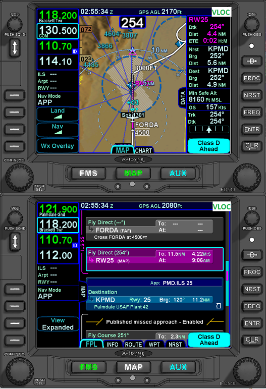 |
||||
|
||||
|
PA20Pacer
Senior Member
Joined: 07 Mar 2012 Location: Illinois (LL22) Status: Offline Points: 161 |
Post Options
Thanks(0)
Quote Reply
Posted: 26 Feb 2016 at 10:13am |
|||
|
I realize that others may not agree, but my opinion is that we are overthinking this issue. The MAP (for the localizer only approach) is a point in space defined on the chart as 6.1 miles from FORDA along the localizer course. SKKEE is a point in space defined as 2.5 DME from PMD along the localizer course, which the chart also specifies as 3.1 miles from FORDA and 3.0 miles from the MAP. The method that I teach my instrument students in cases such as this is to identify the step down fix, SKKEE, when the distance to the MAP is shown as 3.0 miles. I believe that this is legal under the provision for the use of GPS in lieu of DME.
If one does not agree with my interpretation, then one could simply tune the localizer on the IFD540 and set up PMD as the GPS destination waypoint. The localizer would be flown in VLOC mode and the distance to PMD read in the Destination Direct box. Regards, Bob |
||||
|
Bob Siegfried, II
Brookeridge Airpark (LL22) Downers Grove, IL |
||||
|
||||
|
brou0040
Senior Member
Joined: 13 Dec 2012 Location: KIYK Status: Offline Points: 722 |
Post Options
Thanks(0)
Quote Reply
Posted: 26 Feb 2016 at 3:01pm |
|||
|
Bob, What you described above is where the threshold of the runway is, not the MAP. The MAP and the threshold are not collocated.
When you are using your IFD540 GPS/NAV/COMM to shoot the LOC approach, it is not currently easy to set up PMD as the destination waypoint. If you added it after the missed, then the only way to get that readout is from the MAP page datablock, it would not be available on the FPL page.
|
||||
|
||||
|
PA20Pacer
Senior Member
Joined: 07 Mar 2012 Location: Illinois (LL22) Status: Offline Points: 161 |
Post Options
Thanks(0)
Quote Reply
Posted: 26 Feb 2016 at 6:42pm |
|||
|
Hi brou0040,
I agree that setting up PMD as the destination in the IFD540 in order to display the distance pretty much negates any advantage of using an integrated box to set up the approach and prepare to fly the miss. However, as far as the distinction between the runway threshold and the MAP, the speed/time table on the approach plate specifies the distance from FORDA to the MAP as 6.1 miles. This allows one to determine that, in this case, the MAP and the runway threshold appear to be colocated. If they were not colocated, I believe that the profile view would show the distance to both the MAP and the runway threshold, as for the RNAV Y Runway 1 approach at Jackson Hole (KJAC). I believe that the IFD540 will show the distance to the MAP, so as long as the approach plate has the information to determine the distance between the step down fix and the MAP, the distance to the MAP displayed on the IFD540 can be used to determine passage of the step down fix. I fully agree that there cannot be any guessing involved; all the necessary information must be unambiguously available on the approach plate. In all of the cases I have considered, the required information has been available. Regards, Bob |
||||
|
Bob Siegfried, II
Brookeridge Airpark (LL22) Downers Grove, IL |
||||
|
||||
|
Catani
Senior Member
Joined: 21 Jan 2016 Status: Offline Points: 362 |
Post Options
Thanks(0)
Quote Reply
Posted: 28 Feb 2016 at 4:50pm |
|||
Absolutely did not say that DME is required, sorry for making that insufficiently clear. The ability to measure DME distances, either with a DME receiver or a GPS, is required if you're going to use the PMD 2.5 DME distance method to fix SKKEE.
I think what you're saying if that if the SKKEE waypoint were included as part of the GPS approach procedure, you would still be a legal pilot and always use the LOC receiver instead of the GPS to fly down final, and would have an easier time of it identifying when you passed SKKEE because the GPS would have the distance readout to SKKEE like it does for other fixes that are part of the GPS approach procedure. If so, you've missed what I'm trying to get across: doing so would require the GPS during the LOC approach to identify the location of SKKEE, when it's not legal for the GPS to be doing that during the LOC approach. While it may be legal to use SKKEE as an enroute waypoint from Point A to B while flying at cruising altitude, it's not legal to use the GPS to locate SKKEE as a fix on the LOC final. These are black and white TERPS rules we're talking about here, not good-enough approximations which are never good enough for designing approaches. I don't mean to invoke TERPS here as if I were a TERPS expert - I'm not - but only as a way to explain why SKKEE is not allowed to be included in the approach procedure contained in the GPS database. Even though it may well be included in the same GPS database as a stand-alone waypoint. The only legal way to fix SKKEE on the LOC 25 approach is to use the localizer, and they're not going to put SKKEE into the GPS approach procedure to make it easy to cheat. Further, the GPS is not in final approach course mode when flying down a localizer, so it's not nearly as accurate laterally as when flying an LNAV or LPV final approach course - which is another reason not to put SKKEE into the GPS approach database for the LOC 25 approach.
Edited by Catani - 28 Feb 2016 at 5:16pm |
||||
|
||||
|
Catani
Senior Member
Joined: 21 Jan 2016 Status: Offline Points: 362 |
Post Options
Thanks(0)
Quote Reply
Posted: 28 Feb 2016 at 5:07pm |
|||
I don't believe that is technically accurate, and so I don't believe it's correct. The chart says you need DME or a second nav radio. If you have DME, tune it to PMD. If you have a second nav radio, tune it to it to EDW. If you have a GPS, set PMD as the active waypoint and use it to substitute for the PMD DME. The math you are doing to calculate the location of the MAP requires a close examination of the chart in a way not intended by TERPS and is a process prone to error. Further, it's not a substitute for one of the above three approved procedures for fixing SKKEE while on final - it's not published on the chart (say, by indicating SKKEE is both 2.5 PMD and 3.0 MAP).
Exactly so. That's what AC 90-108 and the Instrument Flying Handbook allow you to do. Having said that, some pilots are probably going to fly this approach without ever turning the LOC freq or any VOR; others will do a creative mashup of the LOC and GPS to get to an approximation of what is called for; and all of them will think they are safe enough in doing so. To each his own.
|
||||
|
||||
|
Catani
Senior Member
Joined: 21 Jan 2016 Status: Offline Points: 362 |
Post Options
Thanks(0)
Quote Reply
Posted: 28 Feb 2016 at 5:15pm |
|||
If you have one GPS, you can activate the approach and use it to fly the missed, or you can set up PMD as the active waypoint and use it to identify SKKEE, but you can't do both. This is where having two nav radios helps (so you don't need the GPS to substitute for the PMD DME), allowing you can use your one GPS to load the approach for the missed. Or where having two GPSs, one to load the approach and the other to load PMD, so you can use your one nav radio to fly the localizer and still find SKKEE using your second GPS to substitute for a DME receiver. For those with two nav radios and two GPSs, the approach is dead simple to set up and fly, including finding SKKEE for the step-down, with multiple legal ways to get it done.
Indeed they are.
|
||||
|
||||
|
Post Reply
|
|
 Tweet
Tweet
|
| Forum Jump | Forum Permissions You cannot post new topics in this forum You cannot reply to topics in this forum You cannot delete your posts in this forum You cannot edit your posts in this forum You cannot create polls in this forum You cannot vote in polls in this forum |


 Topic Options
 PA20Pacer wrote: