
|
RNav App , indicator right, GPS not right |
Post Reply 
|
| Author | |
motoadve 
Groupie 
Joined: 13 Nov 2015 Location: Costa Rica Status: Offline Points: 55 |
 Post Options Post Options
") Thanks(0) Thanks(0)
 Quote Reply Quote Reply
 Topic: RNav App , indicator right, GPS not right Topic: RNav App , indicator right, GPS not rightPosted: 27 Feb 2016 at 6:44am |
|
Flew an RNAV approach with my recently installed 540 in my C 182.
Indicator glideslope worked perect, lateral had 1 dot deviation to the left or more during the approach. I was thinking it was the indicator problem. All this was VFR and to test it. When close to the runway I realized the deviation of the indicator was right and if I follow it , it will place me exactly over the runway. On the contrary if I followed the GPS it will put me over the grass off the runway by 50 meters or so. Any ideas what is going on? At one point I got an alert in yellow that said L/NAV Unavail. Use LNAV MDA Will a software update fix this I have 10.1.0 |
|
 |
|
|
MysticCobra
Senior Member 

Joined: 29 Jan 2013 Status: Offline Points: 648 |
Post Options
Thanks(0)
Quote Reply
Posted: 27 Feb 2016 at 8:27am |
|
I'm not sure I understand your scenario. Even when flying RNAV GPS approaches, the CDI is the legal guidance instrument to be followed, so by definition you should have flown needles-centered. If that puts you on the runway, then that's what's supposed to happen and your installation is working as intended.
Now, what was it you were you looking at that wasn't in agreement with the CDI?
Edited by MysticCobra - 27 Feb 2016 at 8:29am |
|
|
|
|
oskrypuch
Senior Member
Joined: 09 Nov 2012 Location: CYFD Status: Offline Points: 3058 |
Post Options
Thanks(0)
Quote Reply
Posted: 27 Feb 2016 at 8:46am |
Specifics please, what airport, what approach? As already asked, what do you mean "followed the GPS", do you mean the magenta line vice the CDI? It almost sounds like the GPS signal might have been week. * Orest |
|
|
|
|
DavidBunin
Senior Member

Joined: 20 May 2015 Location: Rockwall, TX Status: Offline Points: 742 |
Post Options
Thanks(0)
Quote Reply
Posted: 27 Feb 2016 at 9:14am |
|
Larry,
Upgrading to the current software version is always a good idea, but I don't think it will make much difference on this problem. I agree with Orest that it sounds like there was weak GPS signal coverage, and there might be GPS improvements in the latest software version. Page 6-6 of the Pilot's Guide says this about the CAS message you observed: 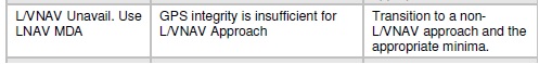 Which also seems to support our theory about weak GPS signal. This also could be a problem with your GPS antenna or coax. David Bunin |
|
|
|
|
brou0040
Senior Member
Joined: 13 Dec 2012 Location: KIYK Status: Offline Points: 720 |
Post Options
Thanks(0)
Quote Reply
Posted: 27 Feb 2016 at 9:52am |
|
I think what the OP is trying to say is that when flying a VLOC approach, it took him to the runway. When he flew an RNAV approach, it took him 50 meters to the side of the runway over the grass; if he was lined up with the runway on the RNAV approach, the CDI was off by a dot or more.
That may be a GPS signal issue to me, but it's interesting that it could be that far off while still providing GPS guidance rather than stating no GPS and forcing you to go to VLOC.
|
|
|
|
|
motoadve
Groupie
Joined: 13 Nov 2015 Location: Costa Rica Status: Offline Points: 55 |
Post Options
Thanks(0)
Quote Reply
Posted: 27 Feb 2016 at 5:54pm |
|
RNAV approach was rwy 27 MROC.
GPS magenta line was being followed by autopilot, and I was checking the indicator it it was always 1 dot to the left. At the end that 1 dot to the left was the correct way to the rwy. Now the autopilot followed the GPS in this scenario, and the indicator just indicated if I was On track or off track. Is there a way to have the autopilot follow the indicator instead? It was quite windy ,so this could be a factor. |
|
|
|
|
oskrypuch
Senior Member
Joined: 09 Nov 2012 Location: CYFD Status: Offline Points: 3058 |
Post Options
Thanks(0)
Quote Reply
Posted: 27 Feb 2016 at 8:50pm |
|
Are you are talking about San Jose / Juan Santamaria in Guatemala? That is (ICAO) MROC.
There is no runway 27 there, it is served by runway 7 / 25 ?! * Orest Edited by oskrypuch - 27 Feb 2016 at 8:54pm |
|
|
|
|
motoadve
Groupie
Joined: 13 Nov 2015 Location: Costa Rica Status: Offline Points: 55 |
Post Options
Thanks(0)
Quote Reply
Posted: 27 Feb 2016 at 10:23pm |
|
You are right rwy 7
|
|
|
|
|
DavidBunin
Senior Member
Joined: 20 May 2015 Location: Rockwall, TX Status: Offline Points: 742 |
Post Options
Thanks(0)
Quote Reply
Posted: 28 Feb 2016 at 9:01am |
|
Larry is based in Costa Rica.
Sounds like you had the autopilot following GPSS guidance (a subset of Heading mode for most autopilots). If you switch to NAV mode, then it should follow the CDI needle and ignore the magenta line. David Bunin |
|
|
|
|
motoadve
Groupie
Joined: 13 Nov 2015 Location: Costa Rica Status: Offline Points: 55 |
Post Options
Thanks(0)
Quote Reply
Posted: 28 Feb 2016 at 9:07am |
|
I dont have a swith for GPS or NAV :(
|
|
|
|
|
brou0040
Senior Member
Joined: 13 Dec 2012 Location: KIYK Status: Offline Points: 720 |
Post Options
Thanks(0)
Quote Reply
Posted: 28 Feb 2016 at 9:29pm |
Sounds like you need to calibrate your OBS to the IFD540, that can be done in the maintenance mode. If your calibration is off by two degrees, then I'd imagine it would show a one dot error when flying on the magenta line, but I'm not positive.
|
|
|
|
|
motoadve
Groupie
Joined: 13 Nov 2015 Location: Costa Rica Status: Offline Points: 55 |
Post Options
Thanks(0)
Quote Reply
Posted: 29 Feb 2016 at 5:17am |
|
When I do an ILS it is perfectly centered though., still needs calibration for GPS approaches?
|
|
|
|
|
oskrypuch
Senior Member
Joined: 09 Nov 2012 Location: CYFD Status: Offline Points: 3058 |
Post Options
Thanks(0)
Quote Reply
Posted: 29 Feb 2016 at 7:37am |
|
If you don't have a switch for GPS/NAV, then your CDI was reading the VOR/LOC, and it has nothing to do with the IF0540 GPS "differences" signal.
There are many reasons for having a VOR?LOC/CDI indication just slightly off, and the most common is the navaid itself out of calibration.
* Orest Edited by oskrypuch - 29 Feb 2016 at 6:03pm |
|
|
|
|
motoadve
Groupie
Joined: 13 Nov 2015 Location: Costa Rica Status: Offline Points: 55 |
Post Options
Thanks(0)
Quote Reply
Posted: 29 Feb 2016 at 10:08am |
|
The thing is rhat the indicator also showed gludeslope , it was followibg the RNAV approach.
This approach has the glideslope at 5 miles and this is when it the glidedlope started working |
|
|
|
|
brou0040
Senior Member
Joined: 13 Dec 2012 Location: KIYK Status: Offline Points: 720 |
Post Options
Thanks(0)
Quote Reply
Posted: 29 Feb 2016 at 10:15am |
|
When you are flying the ILS, it doesn't matter what your CDI is set to, so I'd doubt the 540 is doing anything with the CDI calibration for that approach type. If you were flying a VOR approach, my guess would be that since you have set the VOR CDI and be flying based on VOR guidance, the 540 would also not be applying any calibration to the CDI, but have Avidyne confirm. That is why I'm guessing that the only time the 540 does anything with the CDI calibration is on RNAV approaches. I don't think CDI calibration would have any affect on the glideslope indications.
Edited by brou0040 - 29 Feb 2016 at 10:15am |
|
|
|
|
pburger
Senior Member
Joined: 26 Dec 2013 Location: United States Status: Offline Points: 406 |
Post Options
Thanks(0)
Quote Reply
Posted: 29 Feb 2016 at 11:28am |
|
I've got to enter the fray here. This whole scenario just doesn't smell right.
Quote: "When close to the runway I realized the deviation of the indicator was right and if I follow it , it will place me exactly over the runway. On the contrary if I followed the GPS it will put me over the grass off the runway by 50 meters or so." "if I followed the GPS"?? What does that even mean? The indicator should be based on the GPS. If you fly the indicator (like you're supposed to) you ARE following the GPS. You said that the indicator actually put you in direct line with the runway as expected. You also say, "GPS magenta line was being followed by autopilot", which put you 150' to the right over the grass beside the runway. If that is the case, then the magenta line is WRONG -- I don't buy that for a minute. I would suggest that first off, the magenta line is correct. If not, we're all in big trouble. You yourself said that the indicator appeared to be correct. Are you saying that you could see the magenta line was putting you 150' to the right of the runway? The screen won't zoom in close enough to show that kind of deviation. I believe you have made a HUGE assumption that the autopilot was tracking the magenta line. This is a big red, er magenta, herring. Here is my best guess: Your autopilot was trying it's best to track the course, but just couldn't quite keep up, and was 1 dot off on the indicator. I will assume the wind was out of the north and the autopilot was fighting it the whole way. Hey if the autopilot can't keep up, you need to step in. There might be a calibration issue with your autopilot, or the wind might have just been too much for it in this case. This was a test flight in VFR conditions. I think it revealed that in this particular case, your autopilot didn't track the desired course properly, either due to a calibration/sensitivity issue, or it just couldn't compensate adequately for the wind. Had you hand flown the approach, you would have (should have) flown with the needles in the doughnut on the CDI and everything would have looked perfect. That's my take based on the information I've read so far.
Edited by pburger - 29 Feb 2016 at 11:33am |
|
|
|
|
motoadve
Groupie
Joined: 13 Nov 2015 Location: Costa Rica Status: Offline Points: 55 |
Post Options
Thanks(0)
Quote Reply
Posted: 29 Feb 2016 at 5:05pm |
|
During the flight I took a picture to show my avionics guy.
It reveals the autopilot was following the magenta line, but the indicator was following the ILS, since the ILS freq was set. So my mistake, this is what tests ate for. Will try try again the RNAV approach this week. Now if properly configured the indicator it will give me vertical guidance , correct? |
|
|
|
|
BobsV35B
Senior Member

Joined: 24 Aug 2011 Location: Downers Grove, Status: Offline Points: 131 |
Post Options
Thanks(0)
Quote Reply
Posted: 29 Feb 2016 at 5:41pm |
|
To Motodave,
The glide path will show appropriately if it has a signal to follow from a glideslope transmitter or from a WAAS GPS source while executing a GPS approach that includes a DA or DH. If you are shooting a non precision VHF guided approach, there will be no glidepath. If your are executing a non precision GPS based approach which lists an MDA. there will be NO official glide path, but there may be what is called an advisory glide path. It can be followed until you have to level off to avoid going below the MDA if you like. That is called a non precision approach with an advisory glide path. You CANNOT descend below the MDA unless you have the runway in sight and can remain at the MDA until you determine that the required minima does exist. A lot of folks are getting in trouble following the LNAV+V indication. It has NO standing with the FAA and is purely advisory. There are a few of those advisory glide paths which, if followed below the MDA, will put the aircraft in the trees! Be careful out there! <NG> Happy Skies, Old Bob
|
|
|
Old Bob, Ancient Aviator
|
|
|
|
|
DavidBunin
Senior Member
Joined: 20 May 2015 Location: Rockwall, TX Status: Offline Points: 742 |
Post Options
Thanks(0)
Quote Reply
Posted: 29 Feb 2016 at 7:05pm |
I think we have a failure to communicate here. What model autopilot do you have? What autopilot mode was in use during this event? David |
|
|
|
|
motoadve
Groupie
Joined: 13 Nov 2015 Location: Costa Rica Status: Offline Points: 55 |
Post Options
Thanks(0)
Quote Reply
Posted: 29 Feb 2016 at 7:10pm |
|
Bob thankks fir the explanation David it is a Stec 20 it was in GPSS mode |
|
|
|
|
chflyer
Senior Member

Joined: 24 Jan 2013 Location: LSZK Status: Offline Points: 1022 |
Post Options
Thanks(0)
Quote Reply
Posted: 01 Mar 2016 at 5:47am |
Larry, The Stec 20 itself doesn't have GPSS. That is a separate unit including a GPSS/HDG switch. I think this switch is what was meant by the GPS or NAV question. If you have the GPSS switch in GPS position, then the IFD GPS digital steering commands are converted to analog guidance for the stec 20 a/p. If the switch is in HDG position, then the a/p takes it cue from the stec 20 ST/HD/TRK selection. If HD is selected then a/p guidance is the DG/HSI HDG bug. If in the TRK position, a/p guidance comes from the VHF NAV part of the IFD. Vince |
|
|
Vince
|
|
|
|
|
motoadve
Groupie
Joined: 13 Nov 2015 Location: Costa Rica Status: Offline Points: 55 |
Post Options
Thanks(0)
Quote Reply
Posted: 01 Mar 2016 at 6:23am |
|
Yes I understand this.
The indicator for the 540 is NAV 2 I have a NAV 1 indicator with glideslope and that is the one that is hooked to the autopilot in HDG mode. So the indicator of the 540 is not driven by the autopilot. |
|
|
|
|
chflyer
Senior Member
Joined: 24 Jan 2013 Location: LSZK Status: Offline Points: 1022 |
Post Options
Thanks(0)
Quote Reply
Posted: 01 Mar 2016 at 6:55am |
|
I think you mean that the autopilot is not driven by the 540 (vhf nav2), and so you've made that clear.
When you refer to the CDI above being correct, do you mean the 540/nav2 or the non-IFD NAV1 (or both)? I understand that the a/p was being driven by nav1. Vince |
|
|
Vince
|
|
|
|
|
DavidBunin
Senior Member
Joined: 20 May 2015 Location: Rockwall, TX Status: Offline Points: 742 |
Post Options
Thanks(0)
Quote Reply
Posted: 01 Mar 2016 at 11:39am |
Okay, there's a lot going on here, so let me try to wade through it. You have an STec 20 autopilot. You have a GPSS module. The Nav indicator is not used by the autopilot when in Heading (HDG) mode. The STec 20 autopilot has a Nav mode. In fact, it has two of them: Lo Track and Hi Track. In these modes, the autopilot is following the CDI needle (and only the CDI needle). But from your description that is the #1 CDI needle, which is not the IFD's CDI (your #2). The STec 20 also has a HDG mode, which can follow a heading bug (HDG/HDG) or it can follow the magenta line (HDG/GPSS) depending on the selection on the GPSS/HDG switch. This is a little strange because the GPSS information is definitely coming from the IFD, not the #1 nav radio. So if you say that you were in GPSS mode, then the autopilot should have followed the magenta line. If you were in Nav mode (either Lo Track or Hi Track, but should be Hi Track for an approach) then the autopilot should have followed the CDI needle (from the #1 radio). Did the #1 CDI match the #2 CDI? Sounds like your autopilot can Nav with #1 as a source or it can GPSS with #2 as a source. David |
|
|
|
|
motoadve
Groupie
Joined: 13 Nov 2015 Location: Costa Rica Status: Offline Points: 55 |
Post Options
Thanks(0)
Quote Reply
Posted: 01 Mar 2016 at 1:37pm |
|
The autopilot was following the magenta line.
Since it was an RNAV approach I had Nav 1 in other frequency so it didnt distracted me, the indicator was not working. |
|
|
|
|
DavidBunin
Senior Member
Joined: 20 May 2015 Location: Rockwall, TX Status: Offline Points: 742 |
Post Options
Thanks(0)
Quote Reply
Posted: 02 Mar 2016 at 9:39am |
|
Okay, RNAV (GPS) approach with weak GPS coverage/signal. That's problem #1. Not much we can do about that now.
Also, it sounds like your IFD-CDI may be in need of calibration, which is done in the Maintenance Mode screens. That's (maybe) problem #2. David Bunin |
|
|
|
|
motoadve
Groupie
Joined: 13 Nov 2015 Location: Costa Rica Status: Offline Points: 55 |
Post Options
Thanks(0)
Quote Reply
Posted: 02 Mar 2016 at 12:43pm |
|
Did an approach again today.
The indicator does not work during the GPS approach. Again got the yellow alert LVNAN unavailable use LNAV MDA |
|
|
|
|
BobsV35B
Senior Member
Joined: 24 Aug 2011 Location: Downers Grove, Status: Offline Points: 131 |
Post Options
Thanks(0)
Quote Reply
Posted: 02 Mar 2016 at 12:54pm |
|
Good Afternoon Motoadve,
I may not be following this as close as I should, but have you told us just what approach you are executing? What portion of which indicator is not working? Happy Skies, Old Bob
|
|
|
Old Bob, Ancient Aviator
|
|
|
|
|
motoadve
Groupie
Joined: 13 Nov 2015 Location: Costa Rica Status: Offline Points: 55 |
Post Options
Thanks(0)
Quote Reply
Posted: 02 Mar 2016 at 8:44pm |
|
RNAV to MROC rwy 7
The indicator never worked during the the entire approach. |
|
|
|
|
DavidBunin
Senior Member
Joined: 20 May 2015 Location: Rockwall, TX Status: Offline Points: 742 |
Post Options
Thanks(0)
Quote Reply
Posted: 04 Mar 2016 at 1:15pm |
|
Does the indicator work properly when flying an ILS?
Does the indicator work properly when flying a VOR radial? Does the indicator work properly when flying GPS enroute? |
|
|
|
|
motoadve
Groupie
Joined: 13 Nov 2015 Location: Costa Rica Status: Offline Points: 55 |
Post Options
Thanks(0)
Quote Reply
Posted: 04 Mar 2016 at 1:56pm |
|
Indicator works properly during and ILS
Indicator works properly when flying a VOR radial Indicator does not work properly when flying a GPS enroute Thanks David for looking into this |
|
|
|
|
motoadve
Groupie
Joined: 13 Nov 2015 Location: Costa Rica Status: Offline Points: 55 |
Post Options
Thanks(0)
Quote Reply
Posted: 04 Mar 2016 at 8:56pm |
|
Is it possible the indicator does mot work because there is no WAAS in Costa Rica?
|
|
|
|
|
DavidBunin
Senior Member
Joined: 20 May 2015 Location: Rockwall, TX Status: Offline Points: 742 |
Post Options
Thanks(0)
Quote Reply
Posted: 06 Mar 2016 at 7:33pm |
Doubtful. I believe that any signal problem should affect the aircraft position on the map, but the magenta line and the CDI deviation would have to match. Try this: Set up your data blocks so that the GPS CDI is displayed. Here is an example: 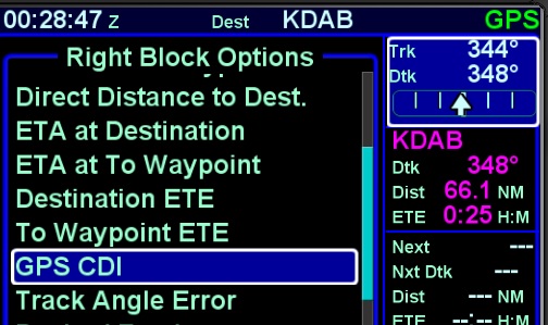 It doesn't have to be a Right-Side datablock, you can place it anywhere you like. Fly around in GPS mode and let us know if the mechanical CDI indication agrees with the on-screen CDI indication. David |
|
|
|
|
motoadve
Groupie
Joined: 13 Nov 2015 Location: Costa Rica Status: Offline Points: 55 |
Post Options
Thanks(0)
Quote Reply
Posted: 06 Mar 2016 at 7:36pm |
|
Thanks will give it a try
|
|
|
|
|
Post Reply
|
|
 Tweet
Tweet
|
| Forum Jump | Forum Permissions You cannot post new topics in this forum You cannot reply to topics in this forum You cannot delete your posts in this forum You cannot edit your posts in this forum You cannot create polls in this forum You cannot vote in polls in this forum |


 Topic Options
 motoadve wrote: