|
Waypoint/Fix "Distance to" needed in FMS/FPL |
Post Reply 
|
| Author | ||
Stevemilner 
Newbie 
Joined: 26 Jan 2017 Location: Dallas, Texas Status: Offline Points: 2 |
 Post Options Post Options
") Thanks(0) Thanks(0)
 Quote Reply Quote Reply
 Topic: Waypoint/Fix "Distance to" needed in FMS/FPL Topic: Waypoint/Fix "Distance to" needed in FMS/FPLPosted: 26 Jan 2017 at 4:54pm |
|
|
Dear Avidyne,
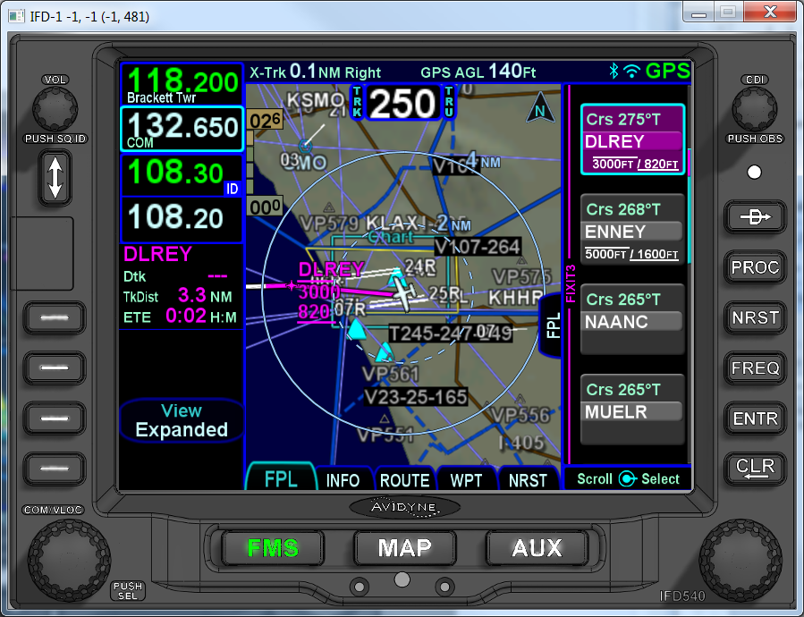
Will the Avidyne IFD 540 10.2 software upgrade address the following concern? Currently when in the FMS mode with the FPL tab open, the small 'waypoint information boxes" depict the course bearing, name of waypoint and altitude restriction. In the attached screenshot from the simulator, I have used the fixes (IF, FAF and RWY) as examples. There is no "distance to" information displayed in each of these waypoint blocks. In the MAP mode with the data tab opened, the box with next waypoint identified provides the following information: waypoint identifier, bearing, distance to and ETE. I have found it awkward and inconvenient to keep switching screens between MAP mode with data tab open to FMS mode with the FPL tab opened in order to acquire both "distance to" and the altitude restriction. I should be able to see both of these on the same display without having to constantly switch modes. In FMS mode with FPL tab opened, the waypoint boxes clearly have space to accommodate the "distance to" information to the left of the altitude information as I have delineated on the attached image. This added information would be of great use to a pilot flying an approach in IMC while very busy flying the plane. He or she would be able to view the current next waypoint and upcoming waypoints at a glance while in the FMS/FPL display, and quickly acquire the "distance to" and altitude restriction information without having to repeatedly switch to MAP/DATA mode. I think this would add a much appreciated convenience that would create fewer distractions at a critical phase of flight, making for safer instrument flying....ultimately saving lives. Your consideration of the matter is much appreciated. Regards, Stephen Milner 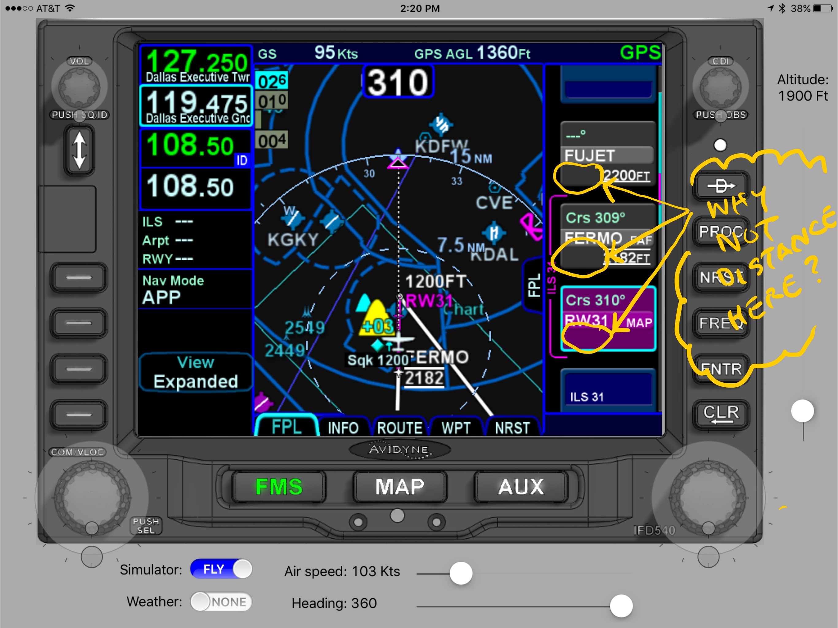
|
||
 |
||
|
Catani
Senior Member 
Joined: 21 Jan 2016 Status: Offline Points: 362 |
Post Options
Thanks(0)
Quote Reply
Posted: 26 Jan 2017 at 5:20pm |
|
|
I don't like to be in FMS mode unless I'm making a change to the flight plan, for fear of changing the plan inadvertently. As a result, I've not used the altitude information on the FMS page, and relied rather on the approach chart.
But as a wrinkle to your suggestion, I think it would be a plus to have the altitude information displayed on the MAP data page, as one of the selectable options on the setup page for those boxes. Not sure I'd rely on that as primary since charts always rule in my mind - but it certainly couldn't hurt.
|
||
|
||
|
MysticCobra
Senior Member

Joined: 29 Jan 2013 Status: Offline Points: 656 |
Post Options
Thanks(0)
Quote Reply
Posted: 26 Jan 2017 at 8:39pm |
|
|
||
|
||
|
oskrypuch
Senior Member
Joined: 09 Nov 2012 Location: CYFD Status: Offline Points: 3061 |
Post Options
Thanks(0)
Quote Reply
Posted: 26 Jan 2017 at 11:53pm |
|
|
I rely on the FMS page minimums (and on MAP depiciton) as primary, and find that feature very helpful. But I always first cross check electronic charts against the IFD minimums. One or the either could be wrong. If a match, it is a valuable cross check.
* Orest Edited by oskrypuch - 26 Jan 2017 at 11:54pm |
||
|
||
|
Catani
Senior Member
Joined: 21 Jan 2016 Status: Offline Points: 362 |
Post Options
Thanks(0)
Quote Reply
Posted: 27 Jan 2017 at 12:06pm |
|
I don't let the box take me anywhere it wants to go. As an example, in another thread I put an assigned SID into the IFD after getting my clearance. But charts on my iPad that actually show me what the SID consists of are primary for me. So I double-check the IFD before engine start, and find an error - the IFD has omitted some waypoints from the SID. The charts are checked many times for accuracy before they are published. Nobody is checking your IFD or other FMS except you. To me, that's a big difference. Finally, my previous post regarding my charts as primary were in reference to the altitude numbers on the IFD, which information is not used by my autopilot or my flight director. So to me, they are irrelevant. It's up to me to identify minimum altitudes and program them into the flight director. I'm going to the source to get them, and I have that chart posted where I can see it at all times - both on my MFD and iPad as a backup. That goes for any other info I want to check that is displayed on the chart - I look there to get it. It's all technique of course. We're all free to operate our equipment as we see fit. Fly safe!
|
||
|
||
|
Catani
Senior Member
Joined: 21 Jan 2016 Status: Offline Points: 362 |
Post Options
Thanks(0)
Quote Reply
Posted: 27 Jan 2017 at 12:11pm |
|
|
||
|
||
|
MysticCobra
Senior Member
Joined: 29 Jan 2013 Status: Offline Points: 656 |
Post Options
Thanks(0)
Quote Reply
Posted: 27 Jan 2017 at 3:02pm |
|
|
My point is that these boxes are certified to fly RNAV approaches, sometimes down to 200' AGL. That includes the accuracy of the waypoints along the charted route that keep you from flying into mountains, buildings, antennas, etc.
By definition, if you're using these boxes to fly IFR approaches in the clouds, then you are, in fact, trusting the accuracy of the data with your life.
|
||
|
||
|
Catani
Senior Member
Joined: 21 Jan 2016 Status: Offline Points: 362 |
Post Options
Thanks(0)
Quote Reply
Posted: 27 Jan 2017 at 3:15pm |
|
|
And Mystic, none of that is done without reference to the charts, and none at all is done in reliance upon FMS altitudes, in my cockpit. We all take a risks flying. It's my goal to reduce them as much as possible. Like I said previously, we're all free to fly any way we want. You do your thing and I'll do mine. We're both entitled.
Edited by Catani - 27 Jan 2017 at 3:16pm |
||
|
||
|
AviSimpson
Senior Member
Joined: 31 Mar 2015 Location: Lincoln, MA Status: Offline Points: 765 |
Post Options
Thanks(0)
Quote Reply
Posted: 27 Jan 2017 at 3:43pm |
|
|
While it looks like there is room to put distance in the spot you identified, that space is actually already allocated to accommodate window altitude constraints (see below). The fact is that there is limited space to display information in that format, so we chose to show information regarding leg definition rather than leg progress. That's why you see the desired track and altitude constraints rather than distance and time to go. Our thinking was that showing the leg definition would tell you the kind of leg and, therefore, how to fly it, while the distance information is graphically shown on the map immediately to the left. Additionally, you could configure one of the datablocks on the left side under the frequencies to show "To Waypoint Information" (again shown below).
This is just one of the places where we have to make tradeoffs because of limited screen space. Hopefully, though, at least you now know the kinds of tradeoffs that we have to make and that there is actually a method to the madness! |
||
|
Simpson Bennett
Avidyne Corporation Product Manager |
||
|
||
|
oskrypuch
Senior Member
Joined: 09 Nov 2012 Location: CYFD Status: Offline Points: 3061 |
Post Options
Thanks(0)
Quote Reply
Posted: 27 Jan 2017 at 6:11pm |
|
No, not really. I rely on all certified data sources equally, and then ensure that the solution suggested makes sense and has a small total error potential. If a chart depiction and the IFD disagreed, I would look to another source to settle it, or if unable then take the most restrictive value. The source data that creates the charts (paper or electronic, although I don't have paper any more) and the IFD, is the same. I don't really see that one certified method of presenting it is any better than another. * Orest Edited by oskrypuch - 27 Jan 2017 at 11:37pm |
||
|
||
|
MysticCobra
Senior Member
Joined: 29 Jan 2013 Status: Offline Points: 656 |
Post Options
Thanks(0)
Quote Reply
Posted: 27 Jan 2017 at 7:12pm |
|
First off, I agree with your point that we can do our own thing. I'm not actually trying to make you change your method of operation. My only intention was to point out that there are some things in an RNAV approach--such as the IFD's determination of what lat/lon you are at, and what a waypoint's lat/lon are--that you have no (practical) way to independently verify in the cockpit. Having a chart in your lap doesn't double-check those data. "The charts are always primary" doesn't really hold when the charts don't actually have the necessary data to truly *be* primary. A dot on a sheet of paper with a five-letter identifier does not allow you to navigate to that location independent of the IFD (or some other box like an IFD). My point is simply that there are, in fact, critical data we rely on in the IFD that have no way to second-check, and you're fooling yourself if you think otherwise. If you can trust those data enough to bet your life on them, it's not such a far stretch to trust other data in the box, though I concede that there's a difference between relying on the IFD alone when there is no other option, and using other data to double-check when such data are available.
|
||
|
||
|
brou0040
Senior Member
Joined: 13 Dec 2012 Location: KIYK Status: Offline Points: 720 |
Post Options
Thanks(0)
Quote Reply
Posted: 27 Jan 2017 at 10:47pm |
|
|
When traking the glideslopend on an RNAV approach, we are using the IFD540 as primary and not our charts. We can double check at certain waypoint as a secondary backup. We are relying on the accuracy of the altitude information in the jepp database and the IFDs ability to process and display that data via some sort of CDI.
|
||
|
||
|
Catani
Senior Member
Joined: 21 Jan 2016 Status: Offline Points: 362 |
Post Options
Thanks(0)
Quote Reply
Posted: 28 Jan 2017 at 10:21am |
|
|
Guys -- The charts can't tell you where you are, only a GPS or legacy navaids can do that. My ordinary iPad can perform that function, which I use as a backup to my two panel GPS's. What I'm talking about is using the IFD as primary data for charted info, especially SIDs and approach data, which I think is a mistake. To each his own.
|
||
|
||
|
FlyingCOham
Senior Member

Joined: 30 Oct 2015 Location: COS (KFLY) Status: Offline Points: 125 |
Post Options
Thanks(0)
Quote Reply
Posted: 28 Jan 2017 at 5:40pm |
|
|
Did anybody notice that only one (or maybe two) of the many responses had anything to do with the original question?
|
||
|
Jim Patton
|
||
|
||
|
DavidBunin
Senior Member

Joined: 20 May 2015 Location: Rockwall, TX Status: Offline Points: 742 |
Post Options
Thanks(0)
Quote Reply
Posted: 30 Jan 2017 at 5:57pm |
|
Yes. This is referred to as internet-normal for forum participants. LOL. |
||
|
||
|
khuffine
Groupie 

Joined: 12 Dec 2015 Location: GSO Status: Offline Points: 68 |
Post Options
Thanks(0)
Quote Reply
Posted: 17 Feb 2017 at 12:24am |
|
|
You are going to have back ups for backups and five iPads to make sure you are right. Time to just fly the plane if you are single pilot. Time to check things is on the ground before u leave if alone. Even airline boxes are not perfect. Much better than anything I ever had but it's getting tooooo much in the cockpit to watch.
|
||
|
Khuffine
|
||
|
||
|
Post Reply
|
|
 Tweet
Tweet
|
| Forum Jump | Forum Permissions You cannot post new topics in this forum You cannot reply to topics in this forum You cannot delete your posts in this forum You cannot edit your posts in this forum You cannot create polls in this forum You cannot vote in polls in this forum |


 Topic Options
 Catani wrote: