
|
How does Nav Mode correlate to RNAV/RNP |
Post Reply 
|
| Author | |
cavu 
Senior Member 
Joined: 17 Apr 2015 Location: KRME Status: Offline Points: 152 |
 Post Options Post Options
") Thanks(0) Thanks(0)
 Quote Reply Quote Reply
 Topic: How does Nav Mode correlate to RNAV/RNP Topic: How does Nav Mode correlate to RNAV/RNPPosted: 19 Apr 2020 at 1:01pm |
|
AC91-100A details a number of system accuracy requirements for different phases of flight. For instance, RNAV 1 is required for RNAV SIDs, ODP and Stars, but RNAV 2 is required for T routes. There are requirements for the pilot to assure the appropriate RNAV accuracy.
1) Is there a correlation between the displayed Nav Mode (APPCH, TERM, ENRT) and RNAV values or is it only representing CDI sensitivity (I think they are related but not the same)? 2) How does the IFD determine which RNAV sensitivity to use. When you are on a DP or STARs in the database? When you are on a T route, would it be using RNAV 2? 3) If user defined waypoints are entered for a route, what is the RNAV value for that route? 4) What alert do we get when this is not met (RNP requirement)?
Edited by cavu - 19 Apr 2020 at 1:02pm |
|
 |
|
|
AviSteve
Admin Group 

Joined: 12 Feb 2018 Location: Melbourne, FL Status: Offline Points: 2327 |
Post Options
Thanks(0)
Quote Reply
Posted: 19 Apr 2020 at 1:24pm |
|
The values actually represent RNP (required navigation performance). 2) It's by nav mode, unless it's specified in the database (like for an RNAV approach). Do you mean a "T" route like an airway prefixed with "T" or a "T" approach like most RNAV approaches have? The airway case would generally be 2, but the approach would vary from 1 to .3. 3) Since the user waypoint would be in the enroute portion, it would likely be 2. But, if the user waypoint happened to be within 30nm of the departure or destination airport, it would be 1. 4) You get "GPS Integrity Lost"
|
|
|
Steve Lindsley
Avidyne Engineering |
|
|
|
|
cavu
Senior Member
Joined: 17 Apr 2015 Location: KRME Status: Offline Points: 152 |
Post Options
Thanks(0)
Quote Reply
Posted: 19 Apr 2020 at 3:00pm |
|
Excellent response, thank you.
I am not familiar with T type approaches. I am familiar with approaches that require authorization and usually an RNP of 0.1 So the database itself dictates the required RNP and that prompts the IFD to what GPS accuracy is required which, in turn, is managed by WAAS and informs us when that level of accuracy is not or will not be available. I take it there is no pilot-induced method to increase RNP (from 1 to .3) on a particular route (say for self entered waypoint special escape procedures)?
|
|
|
|
|
dmtidler
Senior Member

Joined: 12 Feb 2016 Location: USA Status: Offline Points: 635 |
Post Options
Thanks(0)
Quote Reply
Posted: 19 Apr 2020 at 3:19pm |
|
The following pictures are from Navigation 6-21 of the latest IFD500
series PG. I think they will give additional clarity in answering
question 2. 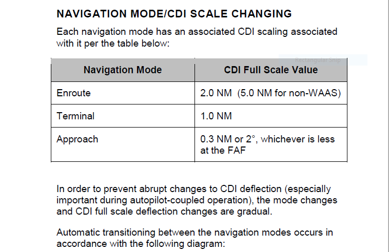 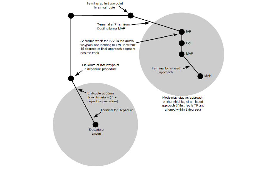 |
|
|
|
|
AviSteve
Admin Group
Joined: 12 Feb 2018 Location: Melbourne, FL Status: Offline Points: 2327 |
Post Options
Thanks(0)
Quote Reply
Posted: 20 Apr 2020 at 9:06am |
No, the pilot cannot specify RNP.
|
|
|
Steve Lindsley
Avidyne Engineering |
|
|
|
|
cavu
Senior Member
Joined: 17 Apr 2015 Location: KRME Status: Offline Points: 152 |
Post Options
Thanks(0)
Quote Reply
Posted: 21 Apr 2020 at 1:46pm |
|
So since the pilot can not manually specify RNP and the default RNAV an FMS, IFD or GNSS will use for unpublished approaches or departures within 30 miles of an airport is RNAV/RNP 1,
what would you say then to using, not only IFD, but any FMS, GNSS system to navigate an unpublished path created under AC91-120 (runway analysis) that depends upon manually entered waypoints (meaning VOR radials/distance) or even published fixes that create a path of only 2000ft lateral obstacle clearance?
Edited by cavu - 21 Apr 2020 at 1:48pm |
|
|
|
|
dmtidler
Senior Member
Joined: 12 Feb 2016 Location: USA Status: Offline Points: 635 |
Post Options
Thanks(0)
Quote Reply
Posted: 21 Apr 2020 at 9:21pm |
|
I think this question brings up an excellent idea that it would be nice to have a datablock that shows ANP (actual nav performance). I believe we can see this as the HPL value on the IFD GPS Status page; however, I think it would be a great option as a datablock on the MAP page.
|
|
|
|
|
chflyer
Senior Member

Joined: 24 Jan 2013 Location: LSZK Status: Offline Points: 1056 |
Post Options
Thanks(0)
Quote Reply
Posted: 22 Apr 2020 at 7:45am |
|
It sounds like with ANP you want to see the GPS accuracy value, in which case you would need HPL & VPL. Not sure how useful that would be in flight given that it changes constantly as the satellite constellation changes. But one can wish for anything.
If you want to know which RNP value currently applies, then you need the navigation mode and/or HAL. The navigation mode has its own datablock, which tells us the applicable CDI max deviation or RNP value as in the table above.
|
|
|
Vince
|
|
|
|
|
AviSteve
Admin Group
Joined: 12 Feb 2018 Location: Melbourne, FL Status: Offline Points: 2327 |
Post Options
Thanks(0)
Quote Reply
Posted: 22 Apr 2020 at 9:03am |
I'd say I don't understand the point of the question. By definition, the IFD doesn't know about unpublished procedures. Anything other than a published procedure is just a series of waypoints that the FMS will fly. RNP alerting will be subject to the terminal/enroute criteria. Edited by AviSteve - 22 Apr 2020 at 9:03am |
|
|
Steve Lindsley
Avidyne Engineering |
|
|
|
|
cavu
Senior Member
Joined: 17 Apr 2015 Location: KRME Status: Offline Points: 152 |
Post Options
Thanks(0)
Quote Reply
Posted: 22 Apr 2020 at 10:18am |
|
The point is that many pilots utilize "runway analysis" escape procedures out of airports, to supposedly, increase their takeoff weight. However, these escape routes, which are created under the pretense of AC120-90 and are built on an obstacle clearance corridor (protective area) of 2000ft laterally from the centerline AND are not found in the database but must be entered manually, waypoint by waypoint. If the GPS utilizes an RNAV of 1 (at best) to these types of routes, then the aircraft could be outside of the protective area and the pilot would only believe he is , at most, a dot off centerline.
I guess the the moral of the story is "not to use these devices for these kinds of procedures"
|
|
|
|
|
dmtidler
Senior Member
Joined: 12 Feb 2016 Location: USA Status: Offline Points: 635 |
Post Options
Thanks(0)
Quote Reply
Posted: 22 Apr 2020 at 11:08am |
|
RNP and ANP in NM are constantly displayed on the lower part
of the ND on many of the Boeing aircraft I am familiar with. Operationally, I have observed that in the lower 48, displayed
ANP stays pretty steady at .02 - .03 NM. At the higher latitudes I operate (approximately 60
N), displayed ANP generally increases to around .05 NM. Obviously, if ANP
were displayed in feet as HPL is on the IFD GPS Status page, displayed ANP
would fluctuate much more.
While the RNP on the Boeings normally change automatically much like it does on the IFDs, RNP can also be manually overridden with a value of the pilot’s choosing. The LNAV CDI scaling is always set to match the value of the active RNP (automatic or manual). I believe that RNP and ANP traditionally deal only with
horizontal navigation accuracy. I’ve only ever seen them expressed in terms of NM. It is my understanding that RAIM covers the required vertical performance monitoring required for SBAS approaches. In my current IFD540 operations and region, I would agree that ANP information is not too useful as the automatic RNP switching and exceedance reporting provided by my IFD540 is sufficient. On the other hand, if I were flying a mountainous obstacle departure which requires a tighter than RNP 1 tolerance, I might find a either a manually selectable RNP/cdi scale or an ANP datablock to verify the ANP is below my needed tolerance highly useful as I take the runway. I would also probably want the Cross Track datablock visible as well. BTW – While I am not at all familiar with the specifics of AC120-90, I did notice it was canceled January 13, 2020. Was it replaced with something else? |
|
|
|
|
cavu
Senior Member
Joined: 17 Apr 2015 Location: KRME Status: Offline Points: 152 |
Post Options
Thanks(0)
Quote Reply
Posted: 22 Apr 2020 at 3:44pm |
|
Sorry I keep typing 120-90 its 120-91 and the current version in AC120-91A Airport Obstacle Analysis.
ANP is not available on most FMS or GPSS and I'm not sure how practical the value would be for a pilot navigating an escape route (ie. what would be your response if the value changes?).
|
|
|
|
|
dmtidler
Senior Member
Joined: 12 Feb 2016 Location: USA Status: Offline Points: 635 |
Post Options
Thanks(0)
Quote Reply
Posted: 22 Apr 2020 at 4:33pm |
|
I agree, after departure if the ANP goes above what is needed on these escape routes you may be in a tight spot. At least you're aware of the tight spot you may be in; hopefully CAVU; hopefully the calculated GPS position is still relatively accurate even though the 95% probability circle of accuracy is larger than required. In any case, that would be an uneasy situation to be in especially IFR. That is why thought I indicated it would be useful in this situation to know if the ANP exceeds the needed threshold taking the runway; i.e. before takeoff. That way a prudent departure or delay decision could be made so you don't takeoff knowing the GPS accuracy isn't what is needed. |
|
|
|
|
cavu
Senior Member
Joined: 17 Apr 2015 Location: KRME Status: Offline Points: 152 |
Post Options
Thanks(0)
Quote Reply
Posted: 22 Apr 2020 at 5:11pm |
|
If I'm not mistaken, ANP is an instantaneous value while RNP is a more predictive value, tied into WAAS warning. Thus knowing ANP would be something but not really to the level of prudent.
|
|
|
|
|
dmtidler
Senior Member
Joined: 12 Feb 2016 Location: USA Status: Offline Points: 635 |
Post Options
Thanks(0)
Quote Reply
Posted: 22 Apr 2020 at 5:47pm |
|
I don’t believe there is anything predictive about RNP. My understanding is that RNP is the limit value of ANP. If ANP (however it is determined by the IFD) exceeds the active RNP, then the “GPS Integrity Lost” message is displayed on the IFD per Steve’s answer to your original question 4.
|
|
|
|
|
cavu
Senior Member
Joined: 17 Apr 2015 Location: KRME Status: Offline Points: 152 |
Post Options
Thanks(0)
Quote Reply
Posted: 23 Apr 2020 at 10:57am |
|
"Limit value" is probably a better term rather than predictive. My understanding is that RNP alerts can also be generated when GPS outages/integrity are predicted so a pilot can proactively avoid RNAV procedures. Thats what I was referring to.
|
|
|
|
|
dmtidler
Senior Member
Joined: 12 Feb 2016 Location: USA Status: Offline Points: 635 |
Post Options
Thanks(0)
Quote Reply
Posted: 23 Apr 2020 at 11:54am |
|
My understanding is that the predictive feature you’re describing is a feature of RAIM which is used in the calculation of HPL (ANP).
|
|
|
|
|
Post Reply
|
|
 Tweet
Tweet
|
| Forum Jump | Forum Permissions You cannot post new topics in this forum You cannot reply to topics in this forum You cannot delete your posts in this forum You cannot edit your posts in this forum You cannot create polls in this forum You cannot vote in polls in this forum |


 Topic Options
 cavu wrote: