Air Data Calculator
Printed From: Avidyne
Category: Avidyne General
Forum Name: IFD 5 Series & IFD 4 Series Touch Screen GPS/NAV/COM
Forum Description: Topics on Avidyne's IFD 5 Series and IFD 4 Series Touch Screen GPS/NAV/COM
URL: http://forums.avidyne.com/forum_posts.asp?TID=2125
Printed Date: 05 Aug 2025 at 3:14am
Software Version: Web Wiz Forums 12.01 - http://www.webwizforums.com
Topic: Air Data Calculator
Posted By: matthewbward
Subject: Air Data Calculator
Date Posted: 01 Dec 2020 at 11:13am
|
Broad question about getting the winds to calculate correctly in the 540: Altitude loads from the GPS, I enter CAS as the IAS, the GPS knows the Heading, I enter the TAT as the OAT from the JPI, and I manually enter the nearest altimeter from Foreflight. The TAS calculates correctly, and probably the DA too, but the winds are crazy. It will show +80 knots headwind or something like that. I've confirmed my units are correct (C vs. F, Mb vs InHg, etc). Is there anything I may be missing to help me diagnose this? Thanks! |
Replies:
Posted By: dmtidler
Date Posted: 02 Dec 2020 at 12:10pm
The wind calculation needs four basic items, TAS, GS, track, and HDG. TAS is calculated using altitude, temperature, and CAS...it sounds like the TAS component appears correct with your manual entries. GS and track are determined internally by your IFD540. What is providing the HDG information to your IFD540? Also, what IFD software version is your IFD540 currently using? |
 matthewbward wrote:
Posted By: matthewbward
Date Posted: 02 Dec 2020 at 12:50pm
|
I thought Heading was coming from the Track on the GPS, but I guess it's possible that was set wrong. Version is 10.2.4.1 |
Posted By: dmtidler
Date Posted: 02 Dec 2020 at 1:24pm
| Without an external heading input or manual entry, the IFD540 doesn't know what the aircraft's heading is. |
Posted By: skitheo
Date Posted: 02 Dec 2020 at 2:44pm
Just to add emphasis that the above is correct. You need to input that from your compass if you don't have an ADAHRS source connected to the IFD540.
|
Posted By: matthewbward
Date Posted: 07 Dec 2020 at 10:56am
Something is still not right. I checked it again this weekend on a really calm day. Winds aloft were forecast at less than 10 knots. Here is a picture of what my box is showing. The 53 knot wind component is certainly not right. The heading was pulled from the DG - I'm assuming it's using this to calculate the WCA or something like that. Does anyone see anything non-sensi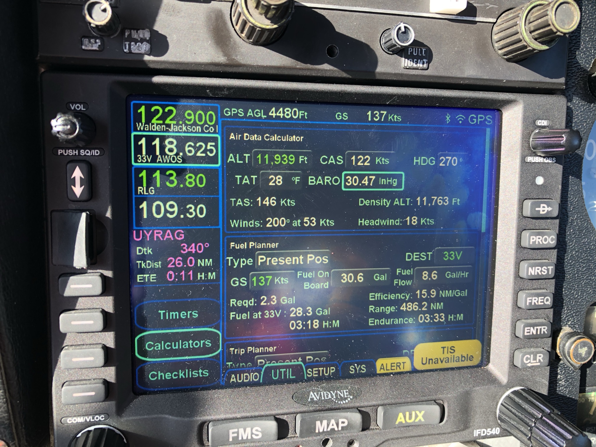 cal that I'm entering? cal that I'm entering?
|
Posted By: paulr
Date Posted: 07 Dec 2020 at 11:35am
|
I'd drop in to https://e6bx.com/e6b/ and have a look. If I plug in HDG 270, TAS 146, and wind 200 @ 53kts, I get a GS of 137. According to them, with the on-screen pressure altitude and OAT, with a CAS of 122, you'd get a TAS of 148. That all seems plausible. Without knowing your actual course, we can't know for sure, but course 291, TAS 146, wind 200 @ 53 gives a heading of 270 and a GS of 137.
|
Posted By: matthewbward
Date Posted: 07 Dec 2020 at 1:57pm
| Thanks for that. I would imagine the E6B calculations within the IFD are right; it's more likely my DG/Compass have errors that contribute to the problem. I suppose my surprise is just in the sensitivity of the calculation. A +- 10 degree error (which my compass probably has!) will get you from sensical to nonsensical winds aloft. |
Posted By: oskrypuch
Date Posted: 07 Dec 2020 at 5:34pm
|
53 knots at 10,000 ft is not by any means "nonsensical". There is often little relation to wind on the ground, and wind higher up, in particular the air is decoupled at the top of the boundary layer. What were the forecast winds at that altitude for your location? * Orest
|
Posted By: matthewbward
Date Posted: 07 Dec 2020 at 6:00pm
| It would be entirely irresponsible to be flying a light airplane in +50 knot winds in the mountains of Colorado - it's ill advised to fly when winds aloft are much over 20 for most of us - and you would most certainly know you were doing it. The same high pressure system is still sitting over the Steamboat Springs area and is currently showing out of 333 at 7 at 12k. |
Posted By: oskrypuch
Date Posted: 07 Dec 2020 at 7:50pm
|
Ah. I seldom fly in the mountains of Colorado, but would agree. More than 20 knots or so, within 30 deg of the perpendicular to mountain ranges, and with an inversion just above, watch out. You didn't mention the specific circumstances. That said, in the flat lands, I can see winds in the 70 to 80 knot range even at 7000ft, in the warm sector, just prior to a system rolling through. Smooth as silk, you wouldn't know without airdata. * Orest
|
Posted By: AndyMeyer
Date Posted: 10 Jan 2021 at 1:20pm
|
Small heading errors do result in significant wind errors. Take your old E6B and try changing the wind heading 10 or 20 degrees and you'll find a significant variation. Imagine cruising at 150 knots tracking west bound... 20 knots on the nose for winds (270@20) GS = 130 knots. Now, if you put in a heading of 250 instead of 270, the winds to maintain a groundtrack of 270 and a GS of 130 is ~328@53 knots. Accuracy plays big for wind computations.
|