Course To An Alttitude Wypt. Avidye410
Printed From: Avidyne
Category: Avidyne General
Forum Name: IFD 5 Series & IFD 4 Series Touch Screen GPS/NAV/COM
Forum Description: Topics on Avidyne's IFD 5 Series and IFD 4 Series Touch Screen GPS/NAV/COM
URL: http://forums.avidyne.com/forum_posts.asp?TID=2414
Printed Date: 01 Jun 2025 at 6:10pm
Software Version: Web Wiz Forums 12.01 - http://www.webwizforums.com
Topic: Course To An Alttitude Wypt. Avidye410
Posted By: Crisvalencia
Subject: Course To An Alttitude Wypt. Avidye410
Date Posted: 09 Oct 2022 at 8:30pm
|
Hello Everyone My topic today is in order to request orientation and guidelines to resolve a problem with a "COURSE TO AN ALTTITUDE WAYPOINT. According the procedure in the chart, the waypoint is located 1 NM after the end of the runway and I must cross that point at 9100 ft or above, however at the moment that I load and active the procedure (SID) on my Avidyne, the Waypoint is shown or erroneously extended 31 NM beyond the runway on the same heading, missleading me into a mountanious terrain... In the correct procedure, I must turn right almost at the end of the runway to avoid a collision with the terrain. Can't anyone help me with this problem. I'm attaching to this Topic, a photo of the error on my avidyne. On the photo the route should be 1, 2 and 3. But WPT #2 is located at the wrong place. I really appreciate your help. Best Regards 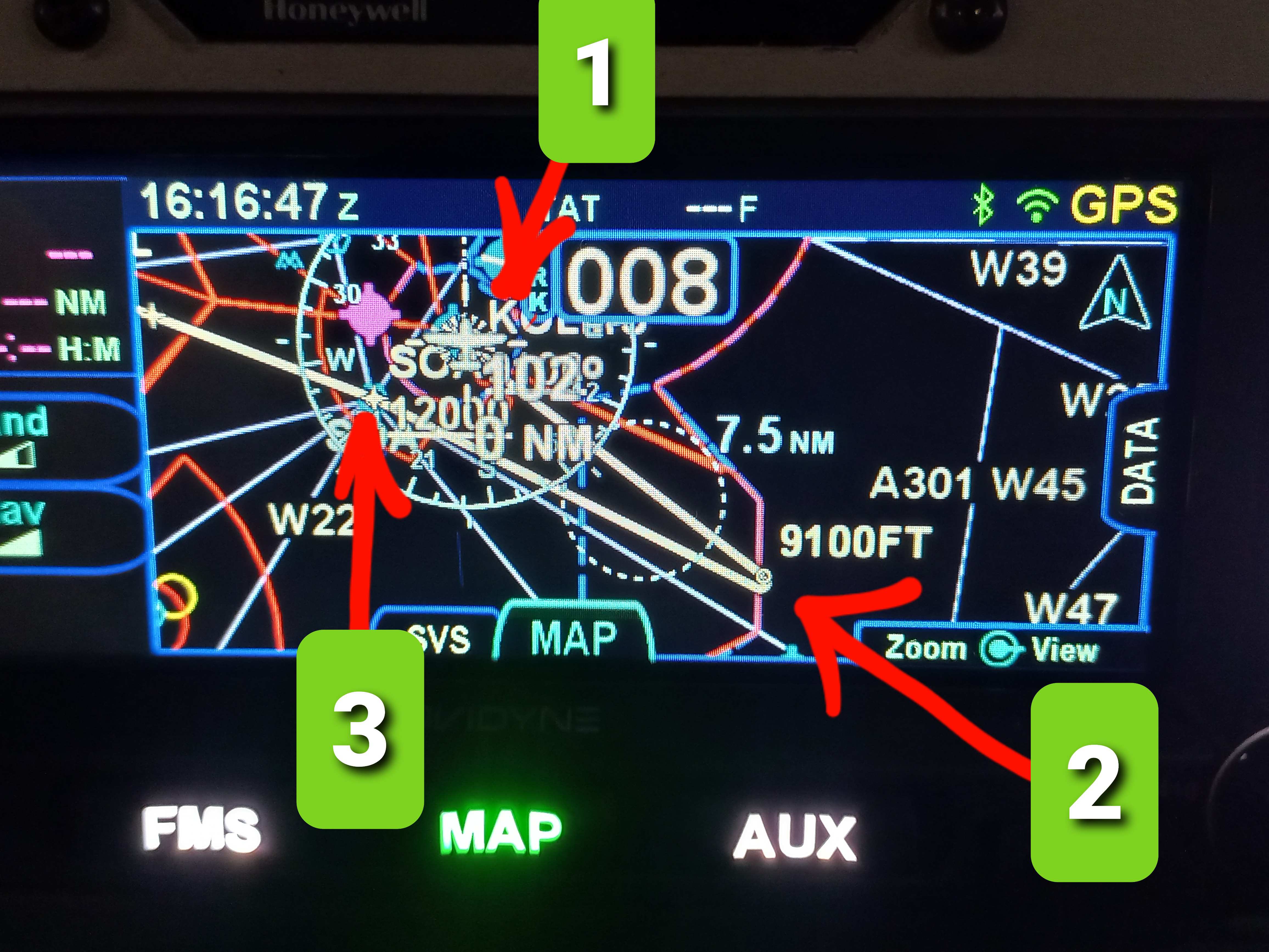 |
Replies:
Posted By: nrproces
Date Posted: 10 Oct 2022 at 10:12am
|
First check is to confirm the position of that waypoint #2, ensuring that the proper coordinates are in the proper place. I would think that is the problem ------------- Sauce |
Posted By: Crisvalencia
Date Posted: 10 Oct 2022 at 10:23am
|
Of Course, Thank you. I did check but it is a "Course to an alttitude WPT". It means the coordinates may vary because it is shown at the place where I reach 9100 ft. I notice something like the system is calculating 50 FPM rate of climb after takeoff. Thats the reason it shows the WPT is presented 31 NM from the runway. My question is how can I modify the rate of climb in the system to obtain the correct position of the wpt #2.? Or How can I fix the problem? Thank you
|
Posted By: dmtidler
Date Posted: 10 Oct 2022 at 8:25pm
|
It would be helpful to see both the SID procedure as well as the full FPL waypoints for this procedure. I'm not convinced it's an error without comparing it to the SID; it appears to me that the 9100' waypoint is programmed as an altitude terminated leg waypoint rather than a crossing waypoint. As an altitude terminated leg waypoint, if the IFD410 has air data input, then the active IFD waypoint should automatically sequence passing 9100'; otherwise, the IFD can be manually sequenced passing 9100' using the "Sequence Leg" L4 LSK button on the FMS - FPL tab. The 31 NM line appears to just be where the extended course/heading intercepts the inbound course to waypoint 2 since the IFD cannot yet determine where along that path the altitude terminated leg waypoint will actually occur.
|
Posted By: AviSteve
Date Posted: 11 Oct 2022 at 2:16pm
Once you start flying and have a real climb rate, the leg will reflect that and terminate at the corresponding position. ------------- Steve Lindsley Avidyne Engineering |
 Crisvalencia wrote:
Posted By: Crisvalencia
Date Posted: 15 Oct 2022 at 9:34am
|
Thank you all for yours replys. I was trying the method you recomend me but the way point is still 31 NM from the end of the runway even when Im in flight and reaching 9100'. Or course in this case FPL needs to be sequenced in order to fly to the next way point and collide with terrain. I dont have problem with this because Im familiar with the area, however, what happens if I were unfamiliar and flying into IMC? That is the problem!
|
Posted By: dmtidler
Date Posted: 15 Oct 2022 at 10:52am
The published 9100’ altitude is a barometric altimeter based altitude. Without air data input to your IFD, the IFD cannot determine when that altitude occurs as it only know GPS altitude; hence the need to manually sequence altitude terminated legs. If your IFD had the required air data input from an air data source such as a G5, ASPEN, or other another ADC; then the IFD would automatically sequence altitude terminated legs.
It’s imperative that every pilot fully understand their IFD’s limitations based on their particular setup and chosen options. |
Posted By: Crisvalencia
Date Posted: 15 Oct 2022 at 11:17am
| Thank you for your information. |