
|
Question about DP on IFD vs Charts differences |
Post Reply 
|
| Author | |||
Speedbird1 
Groupie 

Joined: 16 Mar 2020 Location: New Braunfels Status: Offline Points: 66 |
 Post Options Post Options
") Thanks(0) Thanks(0)
 Quote Reply Quote Reply
 Topic: Question about DP on IFD vs Charts differences Topic: Question about DP on IFD vs Charts differencesPosted: 13 Sep 2020 at 11:09am |
||
|
Hi,
I'm interested as to why the GRAND4.BISOP departure on the IFD is different to the real world charts. Departing RWY 21 at KGCN the procedure is climb to 7000' then turn left HDG 178 to intercept R-196 from GCN and fly direct BISOP. On the IFD Sim; however, it appears to create a radial from BISOP and not GNC which ends up in you having to make a right turn to intercept the course to BISOP which is not correct as per the charts. This appears to be a error which could end up in the DP being flown incorrectly. Or am I missing something? thanks. |
|||
 |
|||
|
Bob H
Senior Member 

Joined: 26 Jan 2018 Location: NH - KMHT Status: Offline Points: 290 |
Post Options
Thanks(0)
Quote Reply
Posted: 13 Sep 2020 at 1:19pm |
||
|
|||
|
Bob
|
|||
|
|||
|
dmtidler
Senior Member

Joined: 12 Feb 2016 Location: USA Status: Offline Points: 635 |
Post Options
Thanks(0)
Quote Reply
Posted: 13 Sep 2020 at 1:47pm |
||
|
The IFD Trainer wants to have you fly a 196 magnetic course to BISOP after 7000; the GCN 196 VOR radial may have at one time been a 196 magnetic course into BISOP; however, now appears to actually run a 200 magnetic course both out of GCN and into BISOP these days.
I’ve seen this same issue with a local VOR; its published radials are currently six degrees different than the magnetic courses that those radials correspond to. One of the airways off this VOR used to have a published hold or two along it. Since Jeppesen coded the holding course based on the published VOR radial that defined the hold, the IFD generated published hold was visibly about six degrees canted from the actual airway. This airway system that was set up to work well for VOR navigation has some interesting effects when those procedures are coded into an FMS.
Edited by dmtidler - 13 Sep 2020 at 1:49pm |
|||
|
|||
|
Speedbird1
Groupie
Joined: 16 Mar 2020 Location: New Braunfels Status: Offline Points: 66 |
Post Options
Thanks(0)
Quote Reply
Posted: 13 Sep 2020 at 2:08pm |
||
|
I've attached a picture. Sorry, I did see that it was fly heading 210 but forgot to type it.
Based on what dmtidler said, is one considered 'wrong'? 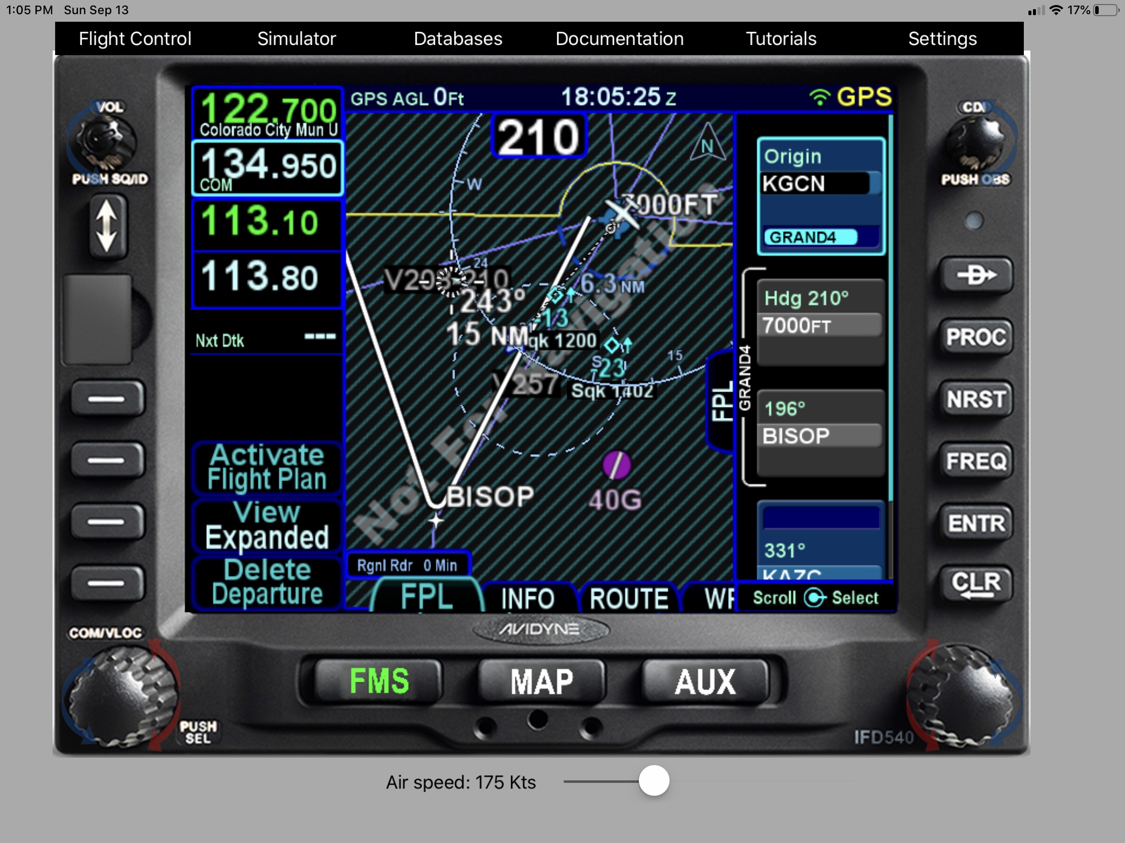 |
|||
|
|||
|
Bob H
Senior Member
Joined: 26 Jan 2018 Location: NH - KMHT Status: Offline Points: 290 |
Post Options
Thanks(0)
Quote Reply
Posted: 13 Sep 2020 at 2:58pm |
||
|
Thanks for the picture.
Interesting. I was not aware of this issue. I wonder how I would react if I encountered this in flight without being forewarned by this forum. What else don't I know?
|
|||
|
Bob
|
|||
|
|||
|
dmtidler
Senior Member
Joined: 12 Feb 2016 Location: USA Status: Offline Points: 635 |
Post Options
Thanks(0)
Quote Reply
Posted: 13 Sep 2020 at 4:58pm |
||
|
I had the same thought.
Once aware of the issue, I can think of multiple ways to deal with it: 1) Rather than select the GRAND4 departure, make the route KGCN GCN BISOP..., activate leg to BISOP before takeoff, manually fly 210 heading until 7000', then turn left 178 heading to join the active GCN to BISOP leg. This is probably the most accurate way to accomplish this departure I can think of. 2) Use the GRAND4 departure, before takeoff, perform a direct to BISOP, activate OBS mode, adjust OBS so that the magenta line also goes over the depicted GCN VOR as best as possible. after 7000' when the IFD cycles to BISOP select OBS mode, adjust inbound BISOP course so magenta line also overlays the GCN VOR. Manually fly 210 heading until 7000', then turn left 178 heading to join the active OBS course to BISOP.. This is less accurate and method 1 as you may not be able to get OBS course to go exactly over the GCN VOR. 3) Use the GRAND4 departure, after 7000' when the IFD cycles to BISOP select OBS mode, adjust inbound BISOP course so magenta line also overlays the GCN VOR. This has the same accuracy as method 2; however, involves some potentially distracting heads down FMS work during a critical phase of flight. 4) Use the GRAND4 departure, select VLOC with GCN tuned and a CDI course of 196 (provided an accurate CDI) before takeoff. Manually fly 210 heading until 7000', then turn left 178 heading to join the active CDI course toward BISOP. Once centered on the CDI course, perform a direct to BISOP then switch to GPS. There are probably numerous other techniques to get this accomplished. Since the GCN 196 radial underlays the leg defined by GCN to BISOP, I would like to see the IFD perform some type automatic behind the scenes activate leg GCN to BISOP after passing 7000' rather than using an erroneous inbound magnetic course to BISOP.
|
|||
|
|||
|
Bob H
Senior Member
Joined: 26 Jan 2018 Location: NH - KMHT Status: Offline Points: 290 |
Post Options
Thanks(0)
Quote Reply
Posted: 13 Sep 2020 at 5:35pm |
||
|
|||
|
Bob
|
|||
|
|||
|
Speedbird1
Groupie
Joined: 16 Mar 2020 Location: New Braunfels Status: Offline Points: 66 |
Post Options
Thanks(0)
Quote Reply
Posted: 13 Sep 2020 at 6:10pm |
||
|
Equally, I like the many ways you've come up with. Very creative.
Should we never trust the IFD on a procedure though? I mean, it seems to me that it isn't always as per the charts which is what I thought it was supposed to be. |
|||
|
|||
|
paulr
Senior Member
Joined: 24 Jan 2014 Status: Offline Points: 565 |
Post Options
Thanks(0)
Quote Reply
Posted: 14 Sep 2020 at 7:25am |
||
That's a fantastic question and one which I often ask myself after seeing posts here.
|
|||
|
|||
|
AviSteve
Admin Group 

Joined: 12 Feb 2018 Location: Melbourne, FL Status: Offline Points: 2327 |
Post Options
Thanks(0)
Quote Reply
Posted: 14 Sep 2020 at 1:25pm |
||
|
The nav database has that procedure coded as "fly heading 210 to 7000ft" then "fly course 197 to BISOP".
The charts are designed for pilots to fly (even those without a GPS). The intersecting radials defining BISOP are necessary if you only have VORs at your disposal. Or you could use the GCN 196 and 26nm if you have a VOR and DME. But the database is designed for the FMS and the FMS generally wants to fly "To" something. In the database, BISOP is just a lat/lon and the FMS will just fly to that position (along the specified course, of course).
|
|||
|
Steve Lindsley
Avidyne Engineering |
|||
|
|||
|
dmtidler
Senior Member
Joined: 12 Feb 2016 Location: USA Status: Offline Points: 635 |
Post Options
Thanks(0)
Quote Reply
Posted: 14 Sep 2020 at 1:47pm |
||
I think most of the DP in the IFD can be used without issue; however, I would suggest reviewing both the legs and map view of the DP ahead of flying it to make sure it matches the procedure and any gaps on the map are understood. I did find another example. The pics below are of the TURNA8 departure from runway 33 at Anchorage, AK (PANC). The way this departure is coded in the IFD after crossing TED VOR results in a very similar issue to the GRAND4 departure at KGCN. What I don't understand in this instance is why Jeppesen coded the TURNA8 departure to fly course 190 to NAPTO after TED instead of fly direct NAPTO after TED. To me, it appears that the IFD uses VOR alignment in its calculations so that if you use OBS mode to/from a VOR waypoint, create a RAD / DIST based waypoint using a VOR as reference waypoint, or have a procedure that generates a course to or from a VOR waypoint, the result is corrected so that it very closely matches what you would have if you were navigating by VHF. In other words, VOR radials may not be identical to their magnetic course even at the VOR station and the IFD appears to correct for this when using a VOR waypoint for its fly course navigation. Non-VOR based waypoints (even if they are part of a VOR based airway) appear to not have the VOR alignment piece of the calculation. When the IFD navigates fly course to/from these waypoints the magnetic course requested is the IFD calculated magnetic course at the waypoint. The problem appears to occur when the IFD is asked to navigate via fly course to a non-VOR waypoint that is also supposed to follow a VOR radial when the VOR is no longer well aligned with the IFD calculated magnetic variation. One last fun fact IFD Trainer App observation I learned in researching this. IFD direct-to navigation and VOR radial navigation are complementary in that they are both great circle navigation; IFD fly course navigation however, appears to be magnetic rhumb line navigation to/from waypoints. Not a big deal for shorter distance OBS navigation, near the equator, or generally north-south courses. The differences become more noticeable at higher latitudes navigating east-west of the waypoint. 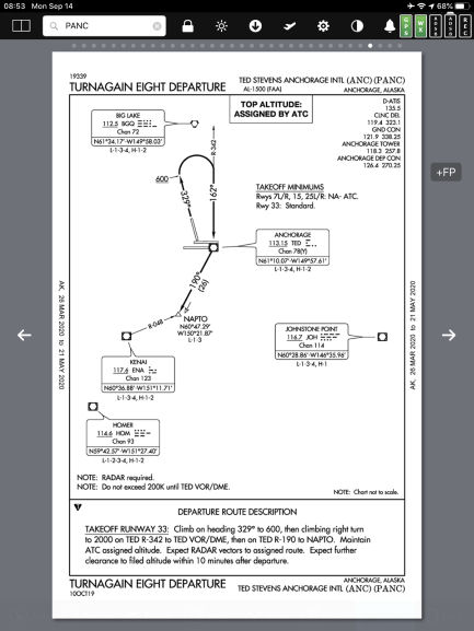 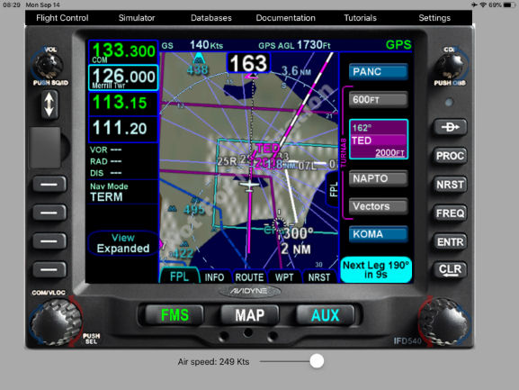 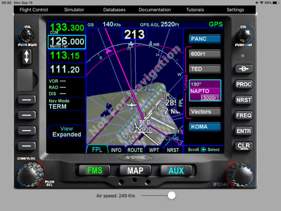 Edited by dmtidler - 15 Sep 2020 at 11:35am |
|||
|
|||
|
94S
Senior Member

Joined: 06 Mar 2014 Location: Bismarck, ND Status: Offline Points: 164 |
Post Options
Thanks(0)
Quote Reply
Posted: 15 Sep 2020 at 11:28am |
||
Steve, That seems to contradict the published procedure, and ATC is expecting the DP to be flown as published. This seems like an opportunity to, at best, get a call from the FAA to explain one's self. And I'm sure that saying that's what the FMS told me do won't cut it. There must be a way to code it to fly to BISOP on the GCN 196 radial. David
|
|||
|
|||
|
Catani
Senior Member
Joined: 21 Jan 2016 Status: Offline Points: 362 |
Post Options
Thanks(0)
Quote Reply
Posted: 15 Sep 2020 at 12:07pm |
||
That assumes it's what the FAA intended, and I for one am not sure what exactly was intended. The chart shows BISOP defined by both a VOR radial and a lat-long. Lat-long coordinates for a fixed point over the Earth never change, so if BISOP is defined by them, the VOR radial must change if it no longer passes through those coordinates. But unless the VOR was re-aligned as mag north moved, the VOR radial defining BISOP should pass through the BISOP lat-long coordinates no matter what mag north moves to. That's a good thing for an obstacle departure, because the obstacles don't move with mag north either. Assuming the GCN VOR has not been re-aligned, then the original published radial to BISOP will remain - in this case the 196 radial - even though mag north has left the building. There is a true course (not published on the chart) associated with the lat-long of both the VOR and BISOP, which a GPS knows all about (since it's database is based upon lat-long, not VOR radials). Unless somebody moves BISOP or the GCN VOR from their original lat-long positions, that true course between them will never change. Thus, mag north can wander wherever it wants to. But the GPS (and FMS) should always plot the course between the VOR and BISOP, unchanged. It looks here like somebody may be changing the course in the database to follow mag north. If so, doing this will introduce errors, as keeping the same 196 MAGNETIC course inbound to BISOP means shifting the inbound course to BISOP as mag north moves. I can see this being a problem in an obstacle departure if this is happening, unless somebody is re-checking the new course to ensure obstacle clearance. Something looks wrong here with the database. Nothing Avidyne can do about it since it can't be going rogue and modifying the database on its own. This is a question for the experts at FAA/TERPS and Jeppesen. They may well have a good explanation for this - or not. Would be interesting to see this either explained or resolved.
|
|||
|
|||
|
AviSteve
Admin Group
Joined: 12 Feb 2018 Location: Melbourne, FL Status: Offline Points: 2327 |
Post Options
Thanks(0)
Quote Reply
Posted: 15 Sep 2020 at 4:12pm |
||
Conceptually, I don't think the chart and the database are contradictory. BISOP is defined to lie on the GCN/196 radial. The chart shows a corresponding course into the BISOP intersection. The intent is for the course to overlay the radial. So, whether you fly the radial outbound from GCN or the published course inbound to BISOP, the path is the same. The only interesting thing here (which may be what you mean by contradictory) is the fact that the chart shows the outbound radial from GCN and the inbound course to BISOP as the same number. The 196 radial is based on the declination of the navaid, which is 15E. However, the local mag var (today) at BISOP is 10.5E. So, to fly a course into BISOP that overlays the 196 radial, you should actually fly a course of 200. I can ask Jeppesen about that, but it might actually turn out to be a question for the FAA as the originator of the data. |
|||
|
Steve Lindsley
Avidyne Engineering |
|||
|
|||
|
AviSteve
Admin Group
Joined: 12 Feb 2018 Location: Melbourne, FL Status: Offline Points: 2327 |
Post Options
Thanks(0)
Quote Reply
Posted: 15 Sep 2020 at 4:13pm |
||
Didn't notice this Catani post until I had the previous one written. I think we're saying the same thing. However, you said that the FMS "should always plot the course between the VOR and BISOP". That would be true if the leg to BISOP was defined as a "track between two fixes". But, the database defines the leg as "course to a fix". That's the rub.
Edited by AviSteve - 16 Sep 2020 at 10:45am |
|||
|
Steve Lindsley
Avidyne Engineering |
|||
|
|||
|
dmtidler
Senior Member
Joined: 12 Feb 2016 Location: USA Status: Offline Points: 635 |
Post Options
Thanks(0)
Quote Reply
Posted: 15 Sep 2020 at 6:12pm |
||
Exactly. A couple of additional thoughts:
|
|||
|
|||
|
Catani
Senior Member
Joined: 21 Jan 2016 Status: Offline Points: 362 |
Post Options
Thanks(0)
Quote Reply
Posted: 16 Sep 2020 at 10:38am |
||
Yes, you're right Steve, I was writing with an assumption (left unstated) to make my point easier to follow that the FAA intended the inbound course to BISOP be defined as a direct path between the lat-long coordinates of both GCN and BISOP. And as I stated to start with, I really don't know what the FAA intended. If I knew what it was, I could have made the same argument but with the correct assumption of FAA intentions. Basically, the route into BISOP (presumably chosen for obstacle clearance purposes as giving the best chance of avoiding a CFIT) is defined by BISOP's lat-long and either (1) GCN's lat-long - the assumption I made for argument's purposes, or (2) some imaginary point with some defined lat-long that is not co-located with GCN - in other words, and inbound course to BISOP not dependent upon GCN, mag north, or any GCN radial. As a pilot flying the latter, you need not know the imaginary point's location, only that you are to fly the published course into BISOP. The nav database will have all this stuff stored as lat-long coordinates and courses, and the FMS will turn it into a displayed route we pilots can follow. Whether it's (1) or (2), however, there's a mismatch between the chart's description of a left turn and the database/FMS avionics on the panel that instructs a right turn. One possible explanation for the mismatch may not involve database errors, but a charting error that does not take into account the change in magnetic variation. The chart's initial instruction is to fly a magnetic course of 210. That course is moving with mag north. Perhaps it once took the pilot west of the inbound course to BISOP, but now, it takes him east. If this is the case, the chart could become dangerous unless the initial heading is modified to take into account variation changes. As we know, the obstacles aren't moving, and the courses over the ground to avoid them don't change either.
|
|||
|
|||
|
dmtidler
Senior Member
Joined: 12 Feb 2016 Location: USA Status: Offline Points: 635 |
Post Options
Thanks(0)
Quote Reply
Posted: 16 Sep 2020 at 5:24pm |
||
|
Here is another oddly IFD coded DP I came across the other day; KSFO OFFSH2.
Below is the procedure (narrative on second page): 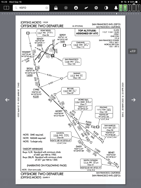 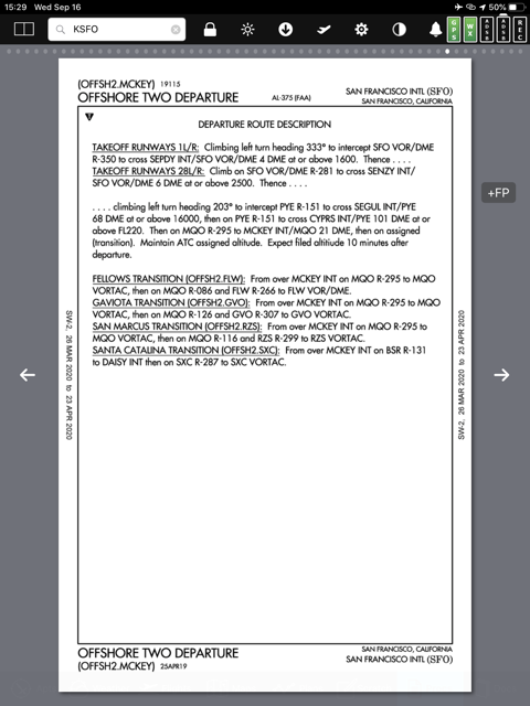 The IFD does fine with the departure off either of the runways 1L/R or 28L/R through getting established on the 203 heading to join the PYE R-151. The next lateral step in the navigation of this procedure is supposed to join the PYE R-151 to SEGUL; however, the IFD DP is coded to join a 151 course to WAMMY instead. There are a couple of issues with this:
Since WAMMY and SEGUL are both on the PYE R-151, at some point while on the 203 heading and approaching the WAMMY SEGUL depicted leg, a manual intervention in the IFD to activate the leg to SEGUL needs to occur to keep this departure sequencing properly. 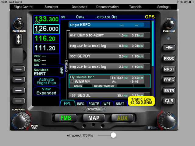 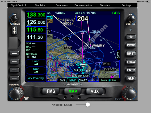 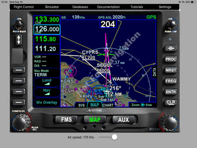 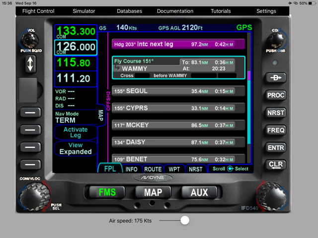 |
|||
|
|||
|
Speedbird1
Groupie
Joined: 16 Mar 2020 Location: New Braunfels Status: Offline Points: 66 |
Post Options
Thanks(0)
Quote Reply
Posted: 16 Sep 2020 at 8:22pm |
||
|
I've actually got a reply from Jepp. Will post it once it comes to a conclusion; however, it appears it has thrown a flag up with them and they are talking to Avidyne about it.
|
|||
|
|||
|
AviSteve
Admin Group
Joined: 12 Feb 2018 Location: Melbourne, FL Status: Offline Points: 2327 |
Post Options
Thanks(0)
Quote Reply
Posted: 17 Sep 2020 at 6:18pm |
||
|
I've worked through this departure with Jeppesen over the last day or two. The crux of the problem is the mag var that was used when coding the procedure. There are three choices to code the leg to BISOP. 1. You could code it as a radial "fly course 196 from GCN for 26.4 miles". That sort of matches the instructions on the chart, but ignores BISOP. There may be a ARINC-424 coding rule that says you should prefer a course-TO leg over a course-FROM leg, I'm not sure. The point is that this is the least attractive choice. 2. You could code it as "fly course 200 to BISOP" and use the current mag var. Doing that would cause the course to more closely match a compass heading, but the course in the procedure would have to be updated periodically based on mag var drift. 3. You could code it as "fly course 196 to BISOP" and use the mag var on which the 196 is based, namely the declination of the VOR when installed of 15E. This matches the chart most closely, but a pilot might notice that he's not actually flying 196 these days. Of course, you would only notice a few degrees on a calm day, but still. Turns out that Jeppesen has a standard that says the procedure should be coded using option 3. However, there was a mistake in coding and the current local mag var was used instead of the VOR station declination. Bottom line is that this error will be corrected in cycle 2011 of the database. I'm glad you noticed the error and pointed it out here because it caused some good discussion. I'm planning to run a utility over the entire database looking for similar errors. If I find any, I'll report back to Jeppesen with the results so that they can correct those as well.
|
|||
|
Steve Lindsley
Avidyne Engineering |
|||
|
|||
|
dmtidler
Senior Member
Joined: 12 Feb 2016 Location: USA Status: Offline Points: 635 |
Post Options
Thanks(0)
Quote Reply
Posted: 17 Sep 2020 at 8:50pm |
||
|
Thanks Steve!
The PANC TURNA8 has this same error after crossing TED VOR going to NAPTO as pointed out above. Not sure why this wasn’t coded as fly direct NAPTO after crossing TED VOR instead of fly course to NAPTO which results in the error. Since the DP is navigating over a non-conditional TED waypoint, I would think that the fly direct option would be available to code in this case.
Edited by dmtidler - 17 Sep 2020 at 8:56pm |
|||
|
|||
|
AviSteve
Admin Group
Joined: 12 Feb 2018 Location: Melbourne, FL Status: Offline Points: 2327 |
Post Options
Thanks(0)
Quote Reply
Posted: 18 Sep 2020 at 11:52am |
||
That will also be fixed in cycle 2011.
|
|||
|
Steve Lindsley
Avidyne Engineering |
|||
|
|||
|
Catani
Senior Member
Joined: 21 Jan 2016 Status: Offline Points: 362 |
Post Options
Thanks(0)
Quote Reply
Posted: 18 Sep 2020 at 12:07pm |
||
Thanks Steve, nice work. I wonder if Jeppesen is setting itself up for problems whichever way it codes the database among those three options. The option 3 they have chosen means someone has to be watching for changes in VOR declination when the FAA re-aligns the VOR to mag north (which I understand the FAA will do from time to time). Since nobody at Jepp was watching how mag north was moving in the way they had coded the database, I'm not sure Jepp will notice and take action to change the database if the FAA re-aligns the VOR at some point. Why don't they use a 4th option: identify the course over the ground the TERPS office used to originally define the procedure (terrain doesn't move, and obstacles usually don't either)? Then code that true course to the BISOP lat/long into the database and forget about it. The option Jepp has chosen will require them to adjust the database from time to time, as the FAA changes the VOR declination by re-aligning the VOR to mag north. If they fail to do that, the course over the ground into BISOP will not remain co-located with the course into BISOP as originally designed to avoid obstacles. Why would Jepp adopt an option that leaves it open to potential error? Also, did Jepp confirm that the 200 mag course pilots follow to start the procedure remains the correct course over the ground as envisioned when the procedure was designed? If the 200 mag course was good 10 years ago, it may be no good now. Any procedure with a mag heading in it to avoid obstacles must be updated periodically.
|
|||
|
|||
|
AviSteve
Admin Group
Joined: 12 Feb 2018 Location: Melbourne, FL Status: Offline Points: 2327 |
Post Options
Thanks(0)
Quote Reply
Posted: 18 Sep 2020 at 12:31pm |
||
|
I think they have the right rule in place (i.e. option 3). While VORs do get adjusted, it doesn't happen all that often. The GCN VOR in question hasn't been adjusted since 1965. As long as the station orientation stays put, using that same declination to define the leg to BISOP will always be correct. Jeppesen will just code to what the FAA source data says. Therefore, if the FAA does decide to realign a VOR, they would have to adjust all departures, arrivals, approaches, airways, holds, etc, that are based on that VOR. That's one of the reasons they don't get realigned all that often. In these cases, Jeppesen just made an honest mistake in coding the mag var using dynamic mag var instead of the station declination. While your proposed 4th option would eliminate all this mag var confusion, it just doesn't fit within the standards. The ARINC-424 standard specifies a magnetic course. You mentioned the "200 mag course" to start the procedure. Correct me if I'm wrong, but I think you're referencing the initial 210 heading leg. Because it's a "fly heading" (versus "fly course") it does not define a path over the ground. Therefore, by design the ground path will be affected by winds. It's effectively "Fly runway heading to 400 feet AGL, then turn left to intercept..." If the airport mag var changes enough to warrant renumbering runway 3/21 to say 4/22, I'm positive that the heading leg will change to specify 220.
Edited by AviSteve - 18 Sep 2020 at 12:33pm |
|||
|
Steve Lindsley
Avidyne Engineering |
|||
|
|||
|
Catani
Senior Member
Joined: 21 Jan 2016 Status: Offline Points: 362 |
Post Options
Thanks(0)
Quote Reply
Posted: 18 Sep 2020 at 4:32pm |
||
That certainly settles the issue for now - true courses are not how we navigate in our ARINC-424 world, so mag courses it will be. Until one day navigating by mag north and a compass will seem as quaint as using a sextant. I can't see any value in holding onto navigation by reference to mag north for much longer. Orient VORs to true north and be done with it. Until then, my 4th option is a no go, and option 3 it is.
Right, your term "mag heading" is more accurate than my careless term "mag course," which presumes a fix to or from that anchors the course. No such fixes exists for a "fly heading" instruction that just gets you clear of the runway by 400 feet before executing any turns.
I too have a lot of confidence that the experts in FAA/TERPS group who draw up these charts will not forget to do that, for so long as we remain navigating by reference to mag north.
|
|||
|
|||
|
dmtidler
Senior Member
Joined: 12 Feb 2016 Location: USA Status: Offline Points: 635 |
Post Options
Thanks(0)
Quote Reply
Posted: 19 Sep 2020 at 9:03am |
||
Thanks Steve! Did you happen to bring up the KSFO OFFSH2 coding with Jeppesen as pointed out above? Also, can you confirm that the IFD navigates direct (great circle) routing when the waypoint navigation indicates fly direct and rhumb line magnetic when the waypoint navigation indicates fly course as appears to be the case?
|
|||
|
|||
|
Bob H
Senior Member
Joined: 26 Jan 2018 Location: NH - KMHT Status: Offline Points: 290 |
Post Options
Thanks(0)
Quote Reply
Posted: 19 Sep 2020 at 7:09pm |
||
|
I just had someone point out to me this FAA InFO:
Subject: Magnetic Variation Differences Between Ground-Based Navigational Aid (NAVAID)
Instrument Flight Procedures (IFP), Area Navigation (RNAV) IFPs, and RNAV Systems It is located here: An excerpt: It is important to understand, however, that RNAV systems, (with the exception of VOR/DME RNAV equipment) navigate by reference to true north and display magnetic course only for pilot reference. As such, a properly functioning RNAV system, containing a current and accurate navigational database, should still fly the correct ground track for any loaded instrument procedure, despite any differences in magnetic course that may be attributed to magnetic variation application. Here is an example: 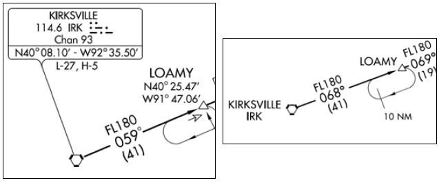 So, the courses should be identical and only differ in the magnetic bearing CHARTED. That is certainly not the case here. If everything is being done in accordance with True North, this anomaly should never have happened. If Jeppesen is plotting courses using magnetic variation, that appears in conflict with this FAA InFO. Edited by Bob H - 19 Sep 2020 at 7:10pm |
|||
|
Bob
|
|||
|
|||
|
AviSteve
Admin Group
Joined: 12 Feb 2018 Location: Melbourne, FL Status: Offline Points: 2327 |
Post Options
Thanks(0)
Quote Reply
Posted: 19 Sep 2020 at 8:49pm |
||
No, that's a different and more interesting case. The bad geometry is because of the aircraft position when the heading leg is active, but you're right that it would be eliminated if WAMMY weren't there. I'll have to ask about that one separately.
Yes, that is correct.
|
|||
|
Steve Lindsley
Avidyne Engineering |
|||
|
|||
|
AviSteve
Admin Group
Joined: 12 Feb 2018 Location: Melbourne, FL Status: Offline Points: 2327 |
Post Options
Thanks(0)
Quote Reply
Posted: 19 Sep 2020 at 8:52pm |
||
While it is true that the FMS operates with respect to true north internally, the courses in the database are not specified according to true north. The FMS computes the true course from a specified mag course and mag var. In this case, the specified mag var was incorrect.
|
|||
|
Steve Lindsley
Avidyne Engineering |
|||
|
|||
|
dmtidler
Senior Member
Joined: 12 Feb 2016 Location: USA Status: Offline Points: 635 |
Post Options
Thanks(0)
Quote Reply
Posted: 19 Sep 2020 at 10:01pm |
||
I understood this article to indicate that the IFP on the left is navaid based and may be flown by non-RNAV equipped aircraft. The charted course / VOR radial indicated not only includes magnetic variation at that location but also takes the declination of the VOR into account. The ultimate result is that LOAMY in its current position will always be on the IRK 059 radial until such time the IRK VOR gets re-aligned to match the current magnetic variation at that location. That leg on on the KORD BDF7 arrival in the IFD shows a magnetic course of 065 out of IRK even though it exactly overlays the IRK 059 radial. The IFP on the right is strictly RNAV based. Even though IRK has a VOR symbol, that is just a depiction that this RNAV waypoint overlays a VOR. Because this is an RNAV only IFP, the 068 course depicted not a VOR radial; it is the FAA determined magnetic course from IRK to LOAMY when the IFP was published. The article also indicates that different RNAV systems may determine that course differently; for instance the IFD once again shows that magnetic course to be 065 on the KORD BENKY5 RNAV arrival. In either case, even with the displayed course differences, the IFD will navigate the correct ground track when utilizing either of these IFP’s.
|
|||
|
|||
|
dmtidler
Senior Member
Joined: 12 Feb 2016 Location: USA Status: Offline Points: 635 |
Post Options
Thanks(0)
Quote Reply
Posted: 19 Sep 2020 at 11:11pm |
||
Thanks again Steve! Having flown the OFFSH2 many times, the 203 heading puts the airplane in a position to intercept the PYE 151 radial southeast of WAMMY. Plus, as I mentioned above, there is no requirement to cross WAMMY upon reaching the PYE 151 radial on this departure. One more deep in the weeds fly direct versus fly course question. With fly direct to/from any waypoint and fly course to/from any non-VOR waypoint, the resulting course appears to indicate IFD determined magnetic course. With fly course to/from any VOR waypoint (including with OBS mode), fly course appears to also take VOR declination into account resulting in the indicated IFD “course” very closely matching the corresponding VOR radial or reciprocal radial of the same value. Do I have that correct?
Edited by dmtidler - 19 Sep 2020 at 11:11pm |
|||
|
|||
|
SB Jim
Senior Member
Joined: 30 Aug 2012 Status: Offline Points: 209 |
Post Options
Thanks(0)
Quote Reply
Posted: 21 Sep 2020 at 6:31am |
||
|
The obstacle departure procedure at Grand Canyon appears to be a non-issue to me.
The last time I checked a VOR receiver was in tolerance if it was plus or minus 4 degrees, and 196 - 200 is 4 degrees. It’s in compliance. A quick scan of the SID shows nothing out there to be a problem. For those of you who didn’t fly for decades in the VOR world, they are sloppy. They scallop. As a result some forgiveness is designed into the system. I would fly it as published without any concerns using the GPS mode of the IFD 540. Regards, Jim
|
|||
|
|||
|
SB Jim
Senior Member
Joined: 30 Aug 2012 Status: Offline Points: 209 |
Post Options
Thanks(0)
Quote Reply
Posted: 21 Sep 2020 at 6:49am |
||
|
Regarding SID’s and ODP’s, there are many cases where Pilot Nav is required, the box isn’t programmed to figure it all out.
I have found it easier in many instances simply to activate the Fly Leg feature (in this example the 151 degree radial to CYPRS) prior to lift off. Use NAV 2 for the initial radial to SEPDY. It seems as though the bulk of these procedures were designed in the VOR days, not our modern point to point GPS navigators. Even modern designs likely consider the need of VOR only aircraft. Take a look at the Santa Rosa Eight departure at KSTS. Years ago the American Bonanza Society had a convention there, and on departure Sunday it was solid IMC. There were more than a few extra minutes spend by departing aircraft getting the navigation equipment set up for that one. The fact that there were mountains nearby added to the incentive to fly the procedure well.
|
|||
|
|||
|
AviSteve
Admin Group
Joined: 12 Feb 2018 Location: Melbourne, FL Status: Offline Points: 2327 |
Post Options
Thanks(0)
Quote Reply
Posted: 21 Sep 2020 at 9:02am |
||
Yes, correct.
|
|||
|
Steve Lindsley
Avidyne Engineering |
|||
|
|||
|
dmtidler
Senior Member
Joined: 12 Feb 2016 Location: USA Status: Offline Points: 635 |
Post Options
Thanks(0)
Quote Reply
Posted: 21 Sep 2020 at 4:19pm |
||
Thanks again Steve!
|
|||
|
|||
|
Bob H
Senior Member
Joined: 26 Jan 2018 Location: NH - KMHT Status: Offline Points: 290 |
Post Options
Thanks(0)
Quote Reply
Posted: 22 Sep 2020 at 9:23pm |
||
What about this situation from Wally Roberts: "Years ago a couple of airplanes almost hit terrain departing KRNO using the WAGGE (now WAGGE 6) because WAGGE was coded as a FB waypoint. As a result of those close calls, the FAA issued the attached Notice to its operations personnel:" EXCERPT: 3.
BACKGROUND. a.
Latent Hazard. Many
operators are using RNAV/FMS navigation equipment to fly non- RNAV/FMS Standard
Instrument Departures (SID) and Standard Terminal Arrival Routes (STAR). In
some cases, because of the software programming, this has led to inaccuracies
in the required tracking of the procedures. These tracking inaccuracies have
resulted in less-than required air traffic control separation and air
traffic control intervention to prevent a possible Controlled Flight Into
Terrain (CFIT) accident. Non-RNAV/FMS procedures often require navigational
tracking over all the specified fixes. Unless RNAV/FMS software is programmed
to fly precisely over a given fix, it will compute, and commence, a turn prior
to the fix so as to join the required track on the other side of the fix, with
the minimal amount of track excursion on the outbound course. This turn
anticipation could result in a turn being started miles prior to the expected
turn point depending on the amount of required track change, wind, and true
airspeed. b. One Example. The WAGGE TWO DEPARTURE at Reno/Tahoe International Airport is an example of this type of procedure. History has shown that some RNAV/FMS software treat the WAGGE intersection as a FLY BY waypoint and not a FLY OVER waypoint. Because of the large course change at this fix, some aircraft have started the turn 5 miles prior to the intersection. A turn prior to WAGGE intersection may create a CFIT danger depending on the climb performance of the aircraft. This problem is not unique to the WAGGE TWO DEPARTURE but only an example of a more widespread problem. |
|||
|
Bob
|
|||
|
|||
|
dmtidler
Senior Member
Joined: 12 Feb 2016 Location: USA Status: Offline Points: 635 |
Post Options
Thanks(0)
Quote Reply
Posted: 23 Sep 2020 at 1:14pm |
||
I think the dual VOR airborne check tolerance is being misapplied in this argument. Geometrically, it appears that the GCN 196 radial crosses the departure end of KGCN runway 21 and diverges about 10 degrees left of extended runway centerline from there. If you follow the IFD course on this DP after 7000', which would most likely occur over or near the departure end of runway 21; it has the aircraft displace between 1.5 and 2 miles to the right of extended runway centerline to intercept a 196 magnetic course to BISOP. Under no wind conditions, upon reaching the IFD 196 magnetic course to BISOP, the aircraft will be located on roughly the GCN 215 to 220 radial. The last time I checked, 215 - 196 is greater than 4 by a factor of almost 4. Precisely following the IFD course to BISOP from there, the aircraft would cross the GCN 200 radial and thus be within 4 degrees of the GCN 196 radial, per this argument, approximately half way between GCN and BISOP; nearly 13 miles from departure. Edited by dmtidler - 23 Sep 2020 at 1:38pm |
|||
|
|||
|
Bob H
Senior Member
Joined: 26 Jan 2018 Location: NH - KMHT Status: Offline Points: 290 |
Post Options
Thanks(0)
Quote Reply
Posted: 23 Sep 2020 at 1:59pm |
||
As always, thanks for your thorough analysis.
|
|||
|
Bob
|
|||
|
|||
|
dmtidler
Senior Member
Joined: 12 Feb 2016 Location: USA Status: Offline Points: 635 |
Post Options
Thanks(0)
Quote Reply
Posted: 23 Sep 2020 at 2:18pm |
||
Isn't that the truth!:)
|
|||
|
|||
|
Post Reply
|
|
 Tweet
Tweet
|
| Forum Jump | Forum Permissions You cannot post new topics in this forum You cannot reply to topics in this forum You cannot delete your posts in this forum You cannot edit your posts in this forum You cannot create polls in this forum You cannot vote in polls in this forum |


 Topic Options
 Speedbird1 wrote: