
|
Suggestions for 10.3 |
Post Reply 
|
Page <1 6789> |
| Author | ||
brou0040 
Senior Member 
Joined: 13 Dec 2012 Location: KIYK Status: Offline Points: 722 |
 Post Options Post Options
") Thanks(0) Thanks(0)
 Quote Reply Quote Reply
 Posted: 05 Jul 2020 at 11:54am Posted: 05 Jul 2020 at 11:54am |
|
I get that each person's ideal NAV tab would be different, but I think the follow-up request to allow a tab of dedicated datablocks is a good feature request, particularly for 440 owners, and allow each user to modify that tab to their preferences. Now if Avidyne were to create an additional datablocks that would replicate an HSI, which might need to be bigger and only fit on that dedicated page (there are already restrictions on which boxes go where based on size), that would also address the earlier feature request.
|
||
 |
||
|
ansond
Senior Member
Joined: 12 Nov 2009 Location: Austin, Texas Status: Offline Points: 152 |
Post Options
Thanks(0)
Quote Reply
Posted: 06 Jul 2020 at 12:07am |
|
|
Another option for 10.3 would be to make the default aux page point to the GPS status page whilst in flight (on ground it could remain pointing to the DB status page)... occasionally, I like double checking my signaling and resolution values and its a pita to have to click over into that page. While I've never had an actual GPS issue, if I did.. I'd want that page to be easily placed for simple recall and checking...
Doug N208LG
|
||
|
||
|
chflyer
Senior Member

Joined: 24 Jan 2013 Location: LSZK Status: Offline Points: 1057 |
Post Options
Thanks(0)
Quote Reply
Posted: 06 Jul 2020 at 1:26am |
|
|
I have both 540 and 440, and I keep the 440 open on the aux fuel mgmt page. The 440 remembers that on shutdown and always comes up with that page now by default on startup. Might work for the GPS status page too ??
|
||
|
Vince
|
||
|
||
|
AviSteve
Admin Group 

Joined: 12 Feb 2018 Location: Melbourne, FL Status: Offline Points: 2349 |
Post Options
Thanks(0)
Quote Reply
Posted: 06 Jul 2020 at 9:01am |
|
Window constraints are already supported. They will be displayed, but cannot be edited. See KLAX RYDRR2 arrival for an example.
|
||
|
Steve Lindsley
Avidyne Engineering |
||
|
||
|
brou0040
Senior Member
Joined: 13 Dec 2012 Location: KIYK Status: Offline Points: 722 |
Post Options
Thanks(0)
Quote Reply
Posted: 06 Jul 2020 at 10:54am |
|
Thanks AviSteve, I guess my follow-on question is what drives some window constraints being populated while others aren't? Is that just coming from Jepp? I see JUUSE on the LAX arrival you mentioned say between 8000 and 9000 feet - exactly how I'd expect it, but CADAB for the RNAV 29 at KSBP is not windowed in the IFD, but the plate shows between 3900 and 6000.
|
||
|
||
|
AviSteve
Admin Group
Joined: 12 Feb 2018 Location: Melbourne, FL Status: Offline Points: 2349 |
Post Options
Thanks(0)
Quote Reply
Posted: 06 Jul 2020 at 11:02am |
|
|
It's driven by the database. I looked at the chart and see the window on the hold at CADAB, but the database definitely shows at or above 3900. I'll shoot Jeppesen an email to see if it's a mistake or if it's being driven by some oddball coding rule. Standby...
|
||
|
Steve Lindsley
Avidyne Engineering |
||
|
||
|
AviSteve
Admin Group
Joined: 12 Feb 2018 Location: Melbourne, FL Status: Offline Points: 2349 |
Post Options
Thanks(0)
Quote Reply
Posted: 07 Jul 2020 at 4:29pm |
|
Turns out it's an idiosyncrasy of database coding. One of the coding rules that Jeppesen follows is that when a course reversal hold (HF leg) has a window constraint, only the lower altitude is coded. That one surprised me as well. Perfect example of why it's always good to compare the FMS to the chart...
|
||
|
Steve Lindsley
Avidyne Engineering |
||
|
||
|
brou0040
Senior Member
Joined: 13 Dec 2012 Location: KIYK Status: Offline Points: 722 |
Post Options
Thanks(1)
Quote Reply
Posted: 07 Jul 2020 at 9:55pm |
|
Interesting, sounds like something we have to accept in this case. Thanks for looking into this!
|
||
|
||
|
Bweb99
Newbie 

Joined: 05 Jun 2019 Location: Pittsburgh, PA Status: Offline Points: 19 |
Post Options
Thanks(0)
Quote Reply
Posted: 17 Jul 2020 at 4:07pm |
|
|
VNAV Labels compatibility with GFC500
|
||
|
||
|
SeanMollet
Newbie

Joined: 05 Aug 2019 Location: OverlandPark,KS Status: Offline Points: 25 |
Post Options
Thanks(0)
Quote Reply
Posted: 17 Jul 2020 at 10:30pm |
|
Yes! Gfc600 as well, since I’m not eligible for the 500. Too many of those spinny things on my plane.
|
||
|
||
|
chflyer
Senior Member
Joined: 24 Jan 2013 Location: LSZK Status: Offline Points: 1057 |
Post Options
Thanks(0)
Quote Reply
Posted: 18 Jul 2020 at 12:35pm |
|
+1 acknowledging that the IFD claims to be GNS-compatible, not GTN-compatible. At this stage, Avidyne should not just be targeting more than GNS compatibility given that the GTN is now adding some features beyond the essential GNS ones. |
||
|
Vince
|
||
|
||
|
Jandair
Newbie
Joined: 19 Nov 2019 Location: KGPM Status: Offline Points: 16 |
Post Options
Thanks(0)
Quote Reply
Posted: 18 Jul 2020 at 9:40pm |
|
|
Is there a preferred place to report things that seem to be coded wrong? Do they go to Jepp or through Avidyne?
On a recent flight, I loaded a flight plan from KLBB to KGPM then added the the TURKI.WESAT2 arrival into KGPM. The arrival procedure is manual termination with vectors to KGPM. The flight plan (and map view) adds a waypoint after WESAT and beyond KGPM and then a return to WESAT. There are no gaps in route. Added about an hour to the overall flight plan. If I enter each waypoint individually along the route, without the actual arrival, everything maps fine. I was able to duplicate this behavior in the IFD100 app. Is there something I need to add after WESAT to connect directly to KGPM?
|
||
|
||
|
dmtidler
Senior Member

Joined: 12 Feb 2016 Location: USA Status: Offline Points: 639 |
Post Options
Thanks(0)
Quote Reply
Posted: 19 Jul 2020 at 11:52am |
|
|
I tried this scenario in both an IFD100 as well as the iPad IFD Trainer. The identical results between the IFD100 and iPad IFD Trainer appeared to be normal IFD behavior for this type of arrival. Per the arrival instructions, the IFD adds a "Manual" 130 degree track vectors leg out of WESAT and that track terminates well beyond KGPM. The expectation and note on the arrival is that at some point along that track, ATC is expected to issue radar vectors off the arrival for an approach. I did not see any flight plan legs that return to WESAT after the 130 degree track leg.
While the map view looks like a great deal of extra flying is added, the flight plan legs and track distance doesn't add time or mileage for the vectors leg. The IFD appeared to correctly calculate the distance and time from WESAT to KGPM. In my experience, this appears to be normal FMS behavior for vectors legs. 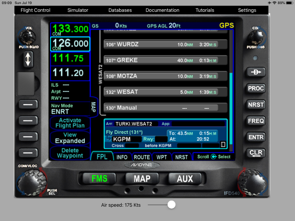 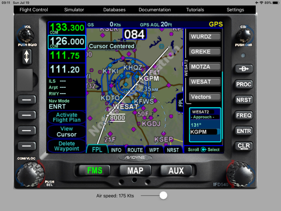 |
||
|
||
|
Jandair
Newbie
Joined: 19 Nov 2019 Location: KGPM Status: Offline Points: 16 |
Post Options
Thanks(0)
Quote Reply
Posted: 24 Jul 2020 at 9:57pm |
|
|
Sorry it took a couple of days... I wanted to get a screen capture of what I am seeing in the plane.
The other piece of the puzzle is the EX5000 MFD. I normally look at the trip page to get a big picture view of the entire flight plan. Notice the DTK entries for the last four items on the flight plan. (The ETE and ETA are not shown because I am on the ground.). All of the flight plan information comes from the IFD and my IFD displays look like the ones in your pictures.
So 133 degrees, then 357 degrees, then 131 degrees and finally 311 degrees back to KGPM. The NM are not exact because I am on the ground, but the delta distance for the last four waypoints is 158nm or about an hour from WESAT to KGPM. This reflects in all of the MFD fields including ETE, fuel needed, fuel remaining, etc... So if I enter the waypoints manually, everything looks good on the MFD. Bottom Line - Is this normal for an FMS system or a coding bug? 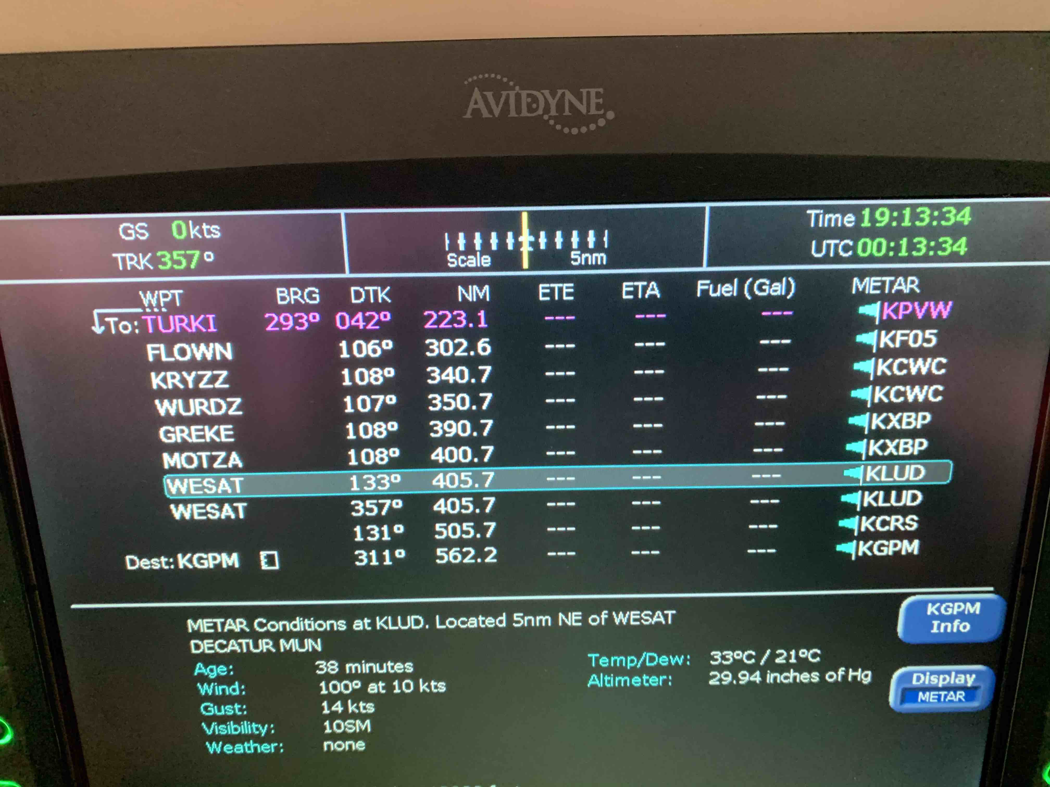 |
||
|
||
|
mfuesting
Newbie

Joined: 14 Mar 2019 Location: Illinois Status: Offline Points: 11 |
Post Options
Thanks(0)
Quote Reply
Posted: 24 Jul 2020 at 10:18pm |
|
|
A nice new feature would be to make the data label (MSA for this area) which I display on the top of the map, turn red and flash anytime you are below the MSA to draw your attention to the fact that your are below MSA. Thanks!
|
||
|
Mike L Fuesting
|
||
|
||
|
dmtidler
Senior Member
Joined: 12 Feb 2016 Location: USA Status: Offline Points: 639 |
Post Options
Thanks(0)
Quote Reply
Posted: 24 Jul 2020 at 11:10pm |
|
|
The IFD piece of the puzzle looks normal to me; I have no experience with the EX5000 MFD and its integration with the IFD.
|
||
|
||
|
Bob H
Senior Member

Joined: 26 Jan 2018 Location: NH - KMHT Status: Offline Points: 290 |
Post Options
Thanks(0)
Quote Reply
Posted: 27 Jul 2020 at 8:15pm |
|
1. Terrain Awareness 2. Forward Looking Terrain Alerting 3. Terrain Caution Aural 4. Terrain Warning Aural
|
||
|
Bob
|
||
|
||
|
nrproces
Senior Member
Joined: 19 Sep 2016 Location: Marion, MT Status: Offline Points: 144 |
Post Options
Thanks(0)
Quote Reply
Posted: 28 Jul 2020 at 10:35am |
|
|
Maybe a "Driftdown" circle based on current winds and terrain?
|
||
|
Sauce
|
||
|
||
|
brou0040
Senior Member
Joined: 13 Dec 2012 Location: KIYK Status: Offline Points: 722 |
Post Options
Thanks(0)
Quote Reply
Posted: 28 Jul 2020 at 10:43am |
|
|
I'd like to see issues with the terrain alerting when landing at published airports resolved.
It was my understanding that when near an airport, the terrain alerting is disabled, but that isn't the case. Is there a chance that the terrain that is triggering the alert when I'm pointing away from the airport (downwind or base) is beyond those limits even though the airplane is within the limits? I was on base turning final this weekend when that thing went off. Do I have to have a runway selected in the FPL to get it to operate properly?
|
||
|
||
|
Bob H
Senior Member
Joined: 26 Jan 2018 Location: NH - KMHT Status: Offline Points: 290 |
Post Options
Thanks(0)
Quote Reply
Posted: 28 Jul 2020 at 12:23pm |
|
Edited by Bob H - 28 Jul 2020 at 12:36pm |
||
|
Bob
|
||
|
||
|
brou0040
Senior Member
Joined: 13 Dec 2012 Location: KIYK Status: Offline Points: 722 |
Post Options
Thanks(0)
Quote Reply
Posted: 28 Jul 2020 at 10:45pm |
|
As stated, it was a terrain warning (not sure exactly which type, I didn't stop to write it down), I was right base for rwy 11 into KTSP. There is a small hill at the approach end of 11 and mountains further to the north. It does the same thing flying into L05. When flying into these airports, we know we are near the mountains and don't need distracting alerts when flying a standard approach for the airport. Against the wisdom of some vocal posters, I've installed a terrain alerting inhibit switch, and I'm very glad I did - and often suggest it to others. I like to keep the alerting enabled and only inhibit it when it's annoying. This works fine when flying through a pass and you can disable it for a few miles. But in this case, I wasn't expecting it to cause an issue and I had a new passenger with me and the thing started throwing startling unnecessary alerts for no valid reason.
Edited by brou0040 - 28 Jul 2020 at 11:00pm |
||
|
||
|
oskrypuch
Senior Member
Joined: 09 Nov 2012 Location: CYFD Status: Offline Points: 3065 |
Post Options
Thanks(0)
Quote Reply
Posted: 29 Jul 2020 at 10:06am |
|
|
Well, I think if you are heading for terrain, it should properly give you a terrain warning. The most likely time for CFIT, is during landing, so not a good time to suppress it. But, whatever works for you. * Orest
|
||
|
||
|
AviSteve
Admin Group
Joined: 12 Feb 2018 Location: Melbourne, FL Status: Offline Points: 2349 |
Post Options
Thanks(0)
Quote Reply
Posted: 29 Jul 2020 at 1:34pm |
|
If the aircraft is within the runway exclusion zone, FLTA alerting should be suppressed. It depends on how tight to the runway you flew the pattern, but it's likely that the aircraft was outside the exclusion zone and that's why you got the alert. The TSO for terrain alerting is complicated and there's only so much we can do to eliminate nuisance alerts. Nevertheless, if you want to send us your logs along with the approximate date and time of the event, we can take a look to see if there's some way we can improve the behavior while staying within the TSO requirements. Send me a PM if you're interested.
Edited by AviSteve - 29 Jul 2020 at 1:35pm |
||
|
Steve Lindsley
Avidyne Engineering |
||
|
||
|
brou0040
Senior Member
Joined: 13 Dec 2012 Location: KIYK Status: Offline Points: 722 |
Post Options
Thanks(0)
Quote Reply
Posted: 29 Jul 2020 at 6:52pm |
|
Alerts are a distraction rather than a safety feature if they go off when there is nothing actionable you should do to correct the situation. If you are flying the proper approach, you shouldn't get alerts. If you get terrain alerts every time you land and are doing things correctly, you would get desensitized to the alerts. The reason for the exclusion is because there are airports where you absolutely want the alerts if you aren't planning on landing there, you are too close to terrain, therefore you can't loosen then alerting criteria, but it'll be going off the entire approach if you don't provide the exclusion.
|
||
|
||
|
Bob H
Senior Member
Joined: 26 Jan 2018 Location: NH - KMHT Status: Offline Points: 290 |
Post Options
Thanks(0)
Quote Reply
Posted: 29 Jul 2020 at 8:46pm |
|
|
There is some high terrain around both of these airports. At KTSP, if you turned base ¾ nm from the end of the runway (not displaced threshold), you were on the edge of the exclusion zone and pointed right at some very high terrain. The exclusion zone at this VFR airport is most likely a 1 nm radius from the ARP. Seems to me the easy solution is to fly a tighter pattern or throw your disable switch when you are landing at a mountainous airport. For IFR airports where the runway configuration is known, the exclusion zone is 2.0 nm laterally and 4.0 nm off each runway end. I think the warning is appropriate under these conditions.
You’ve got your switch, so you’ve got the option to
silence it anytime you want. Edited by Bob H - 29 Jul 2020 at 9:40pm |
||
|
Bob
|
||
|
||
|
oskrypuch
Senior Member
Joined: 09 Nov 2012 Location: CYFD Status: Offline Points: 3065 |
Post Options
Thanks(0)
Quote Reply
Posted: 29 Jul 2020 at 9:34pm |
|
|
I have never seen an FLTA alert on a properly flown IFR approach. Really, by definition there shouldn't be any. But, I have certainly seen alerts when being maneuvered on visual, on occasion. The most obvious one is landing the island airport in Toronto (CYTZ), where once turned on base you encounter the downtown landscape, and alerts go off, PULL UP, etc. But, really, they are appropriate, as I am actually headed right for those obstacles, the CN tower and the rest, the system cannot know (and it would be dangerous to assume) that I will be turning away from these shortly. And, indeed, as soon as I turn final, that stops. If I have passengers, I brief them of the same, it is just treated as a "funny". If that is the kind of alert you are concerned about, and you frequent airports in the midst of terrain, landing not directly off an approach, then having a mute switch might make some sense -- just be doubly sure that it is not off when it shouldn't be. * Orest
Edited by oskrypuch - 29 Jul 2020 at 9:40pm |
||
|
||
|
brou0040
Senior Member
Joined: 13 Dec 2012 Location: KIYK Status: Offline Points: 722 |
Post Options
Thanks(0)
Quote Reply
Posted: 29 Jul 2020 at 11:02pm |
|
|
I'm not sure how you'd miss a critical FLTA warning if you are on a VFR 3/4 mile base flying the pattern to the destination in your flight plan.
Edited by brou0040 - 30 Jul 2020 at 12:01am |
||
|
||
|
brou0040
Senior Member
Joined: 13 Dec 2012 Location: KIYK Status: Offline Points: 722 |
Post Options
Thanks(0)
Quote Reply
Posted: 29 Jul 2020 at 11:41pm |
|
Totally agree, I have it in my checklist to ensure that the FLTA inhibit is disabled as a reminder. I just didn't think the last alert was warranted, there was no need for any urgent actions. KTSP is not a very mountainous airport, its in a pretty big valley. I landed behind a old jet, there is no tight maneuvering required here. It seems like an alert going off here when I told the IFD that this is my destination is an indication that it's a bit too sensitive - or I'm doing something wrong.
|
||
|
||
|
nrproces
Senior Member
Joined: 19 Sep 2016 Location: Marion, MT Status: Offline Points: 144 |
Post Options
Thanks(0)
Quote Reply
Posted: 30 Jul 2020 at 10:24am |
|
|
KBIL when landing to the west, and KCVG when landing on the Center going South, come to mind...
|
||
|
Sauce
|
||
|
||
|
Aerochip
Groupie 
Joined: 24 Sep 2019 Location: Utah Status: Offline Points: 50 |
Post Options
Thanks(0)
Quote Reply
Posted: 30 Jul 2020 at 4:41pm |
|
|
Suggestion:
When on MAP page and say I'm on a vector and then want to go back direct to the waypoint that I had previously been tracking to, I would hit Direct, Enter, Enter. Upon doing so, the IFD440 defaults back to the FMS page. I think it is an issue because the FMS page shows a map much like the MAP page, but of course does not show data blocks, traffic, weather, etc. My suggestion would be for it to default back to the MAP page if that is what was previously being used.
|
||
|
||
|
oskrypuch
Senior Member
Joined: 09 Nov 2012 Location: CYFD Status: Offline Points: 3065 |
Post Options
Thanks(0)
Quote Reply
Posted: 30 Jul 2020 at 4:53pm |
|
Night time or distraction would be the classic issue on a VFR flight. * Orest
|
||
|
||
|
teeth6
Senior Member
Joined: 10 Mar 2014 Status: Offline Points: 741 |
Post Options
Thanks(0)
Quote Reply
Posted: 30 Jul 2020 at 4:54pm |
|
|
it would be nice but I believe the reason is you must be on the FMS page to select the waypoint to go direct to. In your example, you were already heading to the waypoint when the vector started so it was already highlighted but it you were going direct to a different waypoint, you’d have to select it on the FMS page and hit direct.
|
||
|
||
|
Aerochip
Groupie
Joined: 24 Sep 2019 Location: Utah Status: Offline Points: 50 |
Post Options
Thanks(0)
Quote Reply
Posted: 30 Jul 2020 at 5:01pm |
|
I agree and why I'd like to see it changed. Fore example, on a GNS430, doing the same button sequence would not end you on the Flightplan page, which this is effectively doing.
|
||
|
||
|
brou0040
Senior Member
Joined: 13 Dec 2012 Location: KIYK Status: Offline Points: 722 |
Post Options
Thanks(0)
Quote Reply
Posted: 30 Jul 2020 at 9:12pm |
|
You mean like from an unnecessary alert? :)
|
||
|
||
|
oskrypuch
Senior Member
Joined: 09 Nov 2012 Location: CYFD Status: Offline Points: 3065 |
Post Options
Thanks(0)
Quote Reply
Posted: 30 Jul 2020 at 9:46pm |
|
|
One man's distraction, is another's savior. Many ways to skin a cat. * Orest
Edited by oskrypuch - 30 Jul 2020 at 9:46pm |
||
|
||
|
Flybuddy
Senior Member
Joined: 25 Jan 2019 Location: Fort Myers Status: Offline Points: 145 |
Post Options
Thanks(1)
Quote Reply
Posted: 31 Jul 2020 at 9:59am |
|
|
With each release there are probably upwards of 100 suggestions with several requested add ons actually taking place. Many of these are minor and carry minimal improvements. Unfortunately the sum total of constantly adding obscure features can be unwieldy and detract from the overall performance of basic functionality. At some point of saturation it might be worth considering a back to basic software option. One of the strong points of Avidyne over Garmin is it's simpler user interface. We have to be careful that too many "it would nice" features don't put that at risk.
|
||
|
||
|
teeth6
Senior Member
Joined: 10 Mar 2014 Status: Offline Points: 741 |
Post Options
Thanks(0)
Quote Reply
Posted: 31 Jul 2020 at 10:02am |
|
|
Very True!!
|
||
|
||
|
Bob H
Senior Member
Joined: 26 Jan 2018 Location: NH - KMHT Status: Offline Points: 290 |
Post Options
Thanks(0)
Quote Reply
Posted: 31 Jul 2020 at 2:16pm |
|
There is also the matter of departures where the warnings also play a critical role. Balancing both approach and departure profiles combined with terrain for a mix of aircraft from cubs to jets is not simplistic and may lead to the occasional missing savior warning as opposed to the occasional superfluous one. There also isn't any way to know which warnings are helpful to which pilots - i.e. who has situational awareness and who doesn't.
|
||
|
Bob
|
||
|
||
|
Bob H
Senior Member
Joined: 26 Jan 2018 Location: NH - KMHT Status: Offline Points: 290 |
Post Options
Thanks(0)
Quote Reply
Posted: 31 Jul 2020 at 2:32pm |
|
When changes are made, there are almost always unintended consequences. Simple is better.
|
||
|
Bob
|
||
|
||
|
dmtidler
Senior Member
Joined: 12 Feb 2016 Location: USA Status: Offline Points: 639 |
Post Options
Thanks(0)
Quote Reply
Posted: 01 Aug 2020 at 10:47pm |
|
Not sure about the IFD440; however, the IFD540 FMS FPL map continues to display traffic, weather, as well as the left side data blocks.
|
||
|
||
|
cavu
Senior Member
Joined: 17 Apr 2015 Location: KRME Status: Offline Points: 152 |
Post Options
Thanks(0)
Quote Reply
Posted: 12 Aug 2020 at 10:39am |
|
|
When receiving hold instructions, it is something akin to
"Hold North of ABC on the 350 radial, left turns, 5 mile legs" Entering holds into the IFD, It asks for the heading to ABC and its easy to get this mixed up. Is it possible to have an entry field(s) or graphic that is more intuitive with the instructions you get from ATC?
|
||
|
||
|
Bob H
Senior Member
Joined: 26 Jan 2018 Location: NH - KMHT Status: Offline Points: 290 |
Post Options
Thanks(0)
Quote Reply
Posted: 12 Aug 2020 at 8:27pm |
|
 |
||
|
Bob
|
||
|
||
|
cavu
Senior Member
Joined: 17 Apr 2015 Location: KRME Status: Offline Points: 152 |
Post Options
Thanks(0)
Quote Reply
Posted: 13 Aug 2020 at 9:52am |
|
|
That's a good example of why a graphical interface would be helpful. What would that clearance be...
""Hold 10NM West of ABC VOR on the 075 radial." You would enter it as 255 degrees EAST or WEST of the VOR. I know you can view it once its entered on the map but was just asking for a discussion of how to make the first entry easy and correct. I don't really know what it would look like, but perhaps a square of 8 blocks where you immediately press the cardinal heading then enter the radial in the center block. 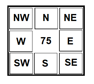 Edited by cavu - 13 Aug 2020 at 9:53am |
||
|
||
|
oskrypuch
Senior Member
Joined: 09 Nov 2012 Location: CYFD Status: Offline Points: 3065 |
Post Options
Thanks(0)
Quote Reply
Posted: 13 Aug 2020 at 10:27am |
|
|
The cardinal compass direction, and the radial number are of course redundant, you don't need to specify both in the IFD And, the HOLD dialog already calculates and specifies the cardinal direction as a cross check, once you enter the inbound course. But, I suppose allowing the TURNS input to be clicked between INBOUND and OUTBOUND (RADIAL from) input might address this, but it would have to be very obvious, perhaps a different color or inverted colors, with the arrow flipped, and with a text OUT and INBD right beside it that you click to change it. (like the AT or above, AT, AT or below selector) * Orest
Edited by oskrypuch - 13 Aug 2020 at 1:38pm |
||
|
||
|
cavu
Senior Member
Joined: 17 Apr 2015 Location: KRME Status: Offline Points: 152 |
Post Options
Thanks(0)
Quote Reply
Posted: 13 Aug 2020 at 10:49am |
|
|
This is the discussion I was looking for. Thanks
I don't think the cardinal heading and radial are redundant, as you could have a hold EAST or WEST of a fix on a radial but the heading entry in the IFD would be different. There must be a reason, that isn't redundant or just heads up, for ATC to give it to you like that. My thinking was more for the sake of how hold clearance are given and making the IFD entry directly from the clearance.
I definitely think the entry graphic needs to be bigger and more intuitive than what is currently shown in the IFD. |
||
|
||
|
Bob H
Senior Member
Joined: 26 Jan 2018 Location: NH - KMHT Status: Offline Points: 290 |
Post Options
Thanks(0)
Quote Reply
Posted: 13 Aug 2020 at 10:57am |
|
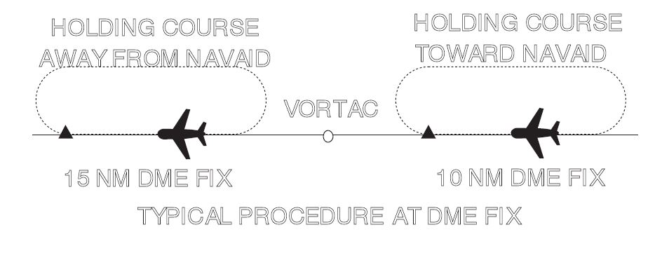
In regard to your example of “…what that clearance would be…”, you can’t hold west of the ABC VOR on the 075 degree radial. The 075 degree radial is east of the VOR. Also note that “Hold 10NM West of the ABC VOR”, does not indicate the direction (N,E,S,W) of the hold from the 10NM waypoint. Radials need to be thought of as a line in space, not a direction. You fly radials inbound or outbound. Although, I’ve heard instructors use the phrase, “fly the radial”, it is poor phrasing and incomplete information. A hold instruction can be given in multiple ways that will not necessarily include any reference to a radial. They can be given as radial, course, bearing, airway or route on which the aircraft is to hold. What if you were told to hold east at mobby intersection on V105? What then? The point of my graphic is that in the two cases, the hold is outbound on the radial in one case and inbound in the other. So, given your concern, you are trying to clarify one case, while obfuscating the other. The industry has always defined holds with a fix and inbound course. Given the vagaries of holds, I can’t think of a better way to define them. Yes, they can be confusing, but no matter how you re-define it, it is still a fix and a direction. Substituting one direction for another will not reduce the confusion. The bottom line is that the pilot is given a clearance on where and how to hold. The pilot then needs to figure out the inbound course to fly. The hold clearance itself can never reliably provide specific course information, the pilot is always left to figure it out. Edited by Bob H - 13 Aug 2020 at 11:11am |
||
|
Bob
|
||
|
||
|
cavu
Senior Member
Joined: 17 Apr 2015 Location: KRME Status: Offline Points: 152 |
Post Options
Thanks(0)
Quote Reply
Posted: 13 Aug 2020 at 11:21am |
|
|
I was actually referring to holding west of the fix but east of the VOR (you didn't actually draw that you had a Hold East of the fix on the 270 radial, I should have just used your example).
If you are at a published intersection then the IFD should know that airways go thru it and a simple pull-down would solve that (or as published) but those are not the holds that cause confusion. The point of the cardinal heading select and radial entry would be to eliminate the erroneous inbound course entry. I'm really just thinking "out loud" here. Seems there might be a better way to depict these graphically as you are constructing it and eliminating the erroneous possibilities. |
||
|
||
|
Bob H
Senior Member
Joined: 26 Jan 2018 Location: NH - KMHT Status: Offline Points: 290 |
Post Options
Thanks(0)
Quote Reply
Posted: 13 Aug 2020 at 12:13pm |
|
My concern is that there are so many ways to define a hold, that in my opinion, coming up with a menu of possibilities would create more confusion. Holds do not have to be on a radial or airway. As you step through a menu of possibilities, each one needs to be evaluated and determined if applicable. I think it comes down to situational awareness. If one is inputting an erroneous inbound course, there is a SA issue and an issue with thinking about a radial as a direction to fly. It is not. It is a line in space. A radial merely narrows the holding course down to two possibilites. If I have to look at a menu and determine if that selection applies to my inbound course, I must have already determined what my inbound course is. So instead of evaluating multiple menu items against my inbound course, why not just input my inbound course? If the pilot has good situational awareness, at most it requires adding or subtracting 180 deg. I caution against adding menu items in the name of "easier", when often times it simply reduces pilot SA and removes the pilot from the "picture" of what the plane is doing and where it is going. So, I do not favor a menu system of any kind. The only thing I could get behind is an OBS type twist of the knob while a graphic holding pattern rotates on the screen. However, it would still require entering right or left turns, and time or distance of the hold, so I'm ambivalent about it.
|
||
|
Bob
|
||
|
||
|
oskrypuch
Senior Member
Joined: 09 Nov 2012 Location: CYFD Status: Offline Points: 3065 |
Post Options
Thanks(0)
Quote Reply
Posted: 13 Aug 2020 at 1:41pm |
|
|
Personally, I don't see a lot of value to changing how the HOLD dialog works in the IFD, I don't find it confusing myself, at worst all you have to do is flip one bearing by 180* as necessary. I would consider it basic SA to have that clear in your mind, what the hold looks like, before you start entering it. * Orest
Edited by oskrypuch - 13 Aug 2020 at 1:42pm |
||
|
||
|
cavu
Senior Member
Joined: 17 Apr 2015 Location: KRME Status: Offline Points: 152 |
Post Options
Thanks(0)
Quote Reply
Posted: 13 Aug 2020 at 6:47pm |
|
|
Try to enter a hold 5NM east of a VOR where there is no published fix on an airway in the IFD. Its not easy. You have to eyeball a point that is 5NM from the VOR. Odds are you will be off, can't change it on the FP, have to delete and re-enter, then there's getting right on the airway which is also not easy. Its not "Avidyne" easy. If you do get the waypoint you can then put a hold there.
I can envision a much easier way to place and orient (the twist the hold pattern using a knob is not bad). The current dialogue box for holds is not fully visible with the map view open, so there is very little visual reference involved. The little holding pattern does not reorient when you change the heading, confusing to interpret with East/West referenced in hold dialogue box. |
||
|
||
|
Post Reply
|
Page <1 6789> |
 Tweet
Tweet
|
| Forum Jump | Forum Permissions You cannot post new topics in this forum You cannot reply to topics in this forum You cannot delete your posts in this forum You cannot edit your posts in this forum You cannot create polls in this forum You cannot vote in polls in this forum |


 Topic Options
 Bob H wrote: